You must be logged in to view this content. Click Here to become a member of IndyWX.com for full access. Already a member of IndyWx.com All-Access? Log-in here.
December 2020 archive
Permanent link to this article: https://indywx.com/2020/12/12/video-fresh-thoughts-on-both-tuesday-night-wednesday-and-the-overall-pattern-through-the-holidays/
Dec 12
Client Brief: Eyeing 1st Widespread Accumulating Snow Of The Season…
Type: Impactful wintry weather
What: Accumulating snow
When: Tuesday night & Wednesday
Temperatures: Lower 30s
Wind: NE 10-20 MPH early in the event, shifting to the NW and decreasing to 5-10 MPH Wednesday
Blowing/ Drifting: Minimal
Pavement Impacts: Salting and plowing required
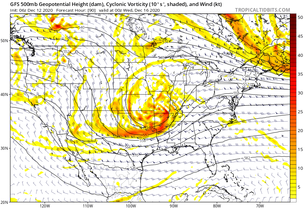
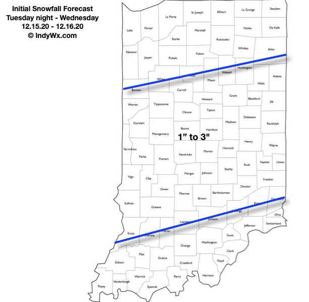
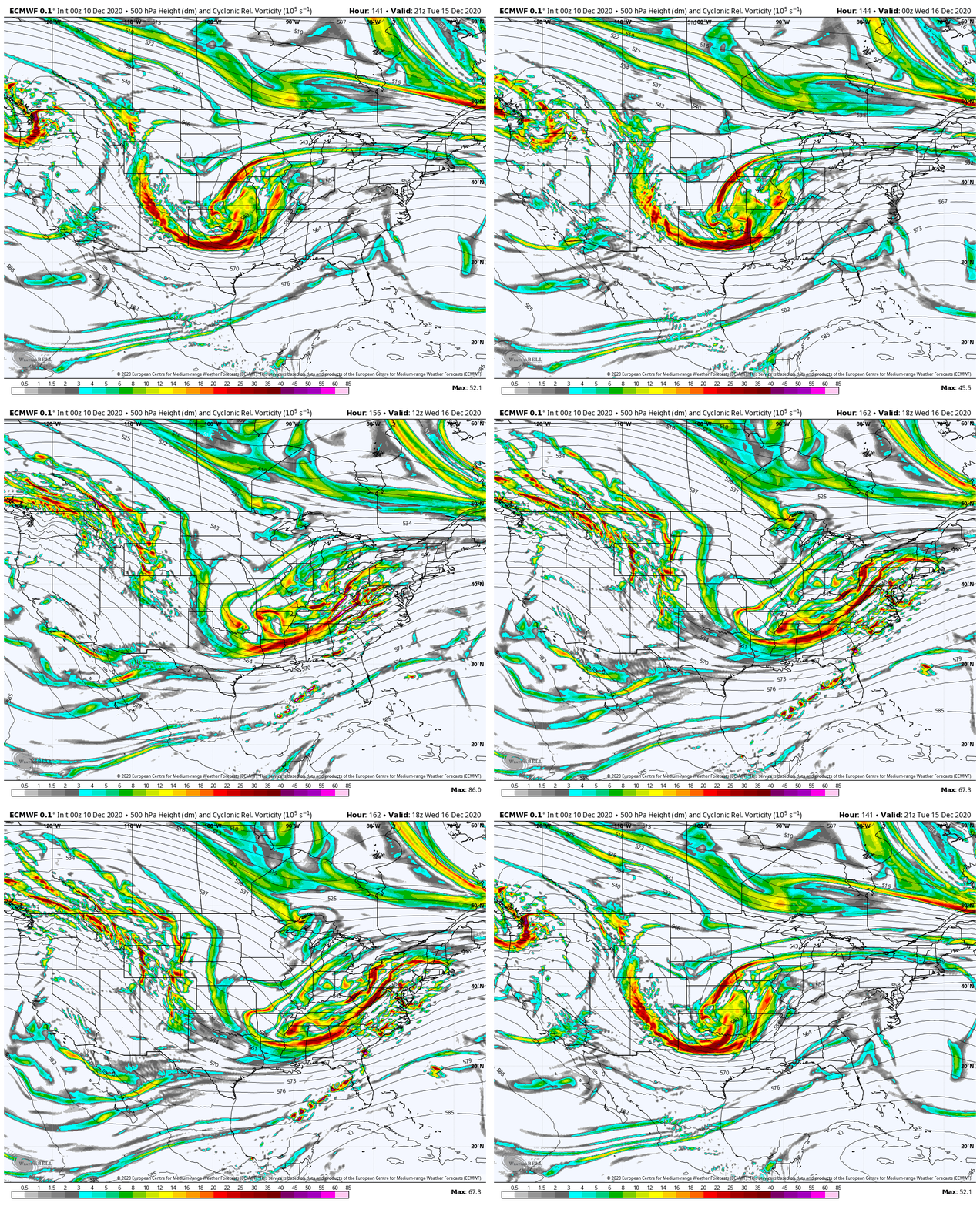
Summary: An area of low pressure will move across northern Texas (Monday night and Tuesday morning) northeast into the lower Ohio Valley (Wednesday morning). In response to this feature, a secondary surface low will form in the northern Gulf of Mexico Tuesday night and it’s this surface low that will eventually “steal the show” moving northeast and being located off the Carolina coast Wednesday before eventually blowing up into a good ole fashioned nor’easter Wednesday night and Thursday. Before this energy transfer takes place, we should see a stripe of accumulating snow extend northeast into the Ohio Valley Tuesday night and Wednesday. From this distance, it appears as if central IN is in store for the 1st widespread snow event of the season, but the devil’s still in the details. We’ll have to monitor the energy transfer closely. Additionally, it’ll be important to keep eyes on the developing Gulf low. Should this system generate convection in more rapid fashion than currently thought, it would steal some of the moisture from the initial low into the OHV. As it is, the early thinking here is that this is a 1″ to 3″ type event for our immediate region. Should the Gulf low organize a little slower, the possibility is there for heavier totals. Widespread snow should diminish and come to an end late Wednesday morning (west) and by afternoon (east). Thursday and Friday look dry and cold.
Confidence: Medium
Next Update: This afternoon (video package)
Permanent link to this article: https://indywx.com/2020/12/12/client-brief-eyeing-1st-widespread-accumulating-snow-of-the-season/
Dec 11
VIDEO: Near Record High Today; Rain Arrives Tonight And Continuing To Keep An Eye On Early Next Week…
You must be logged in to view this content. Click Here to become a member of IndyWX.com for full access. Already a member of IndyWx.com All-Access? Log-in here.
Permanent link to this article: https://indywx.com/2020/12/11/video-near-record-high-today-rain-arrives-tonight-and-continuing-to-keep-an-eye-on-early-next-week/
Dec 10
VIDEO: Pattern Evolution Into Early-January; Wintry Mischief On Deck Early Next Week?
Tonight we look at the pattern evolution into early January, as well as take a deeper dive into 2 systems of note: heavy rain late Friday night into Saturday and…
You must be logged in to view this content. Click Here to become a member of IndyWX.com for full access. Already a member of IndyWx.com All-Access? Log-in here.
Permanent link to this article: https://indywx.com/2020/12/10/video-pattern-evolution-into-early-january-wintry-mischief-on-deck-early-next-week/
Dec 10
Long Range Update: Christmas Period Comes Into View…
Month-to-date, it’s been a cold open to December, but a warming trend got underway yesterday and will go into high gear today. We forecast highs to “flirt” with 60° for many central Indiana neighborhoods with sunny skies. Find a way to get outside and enjoy!
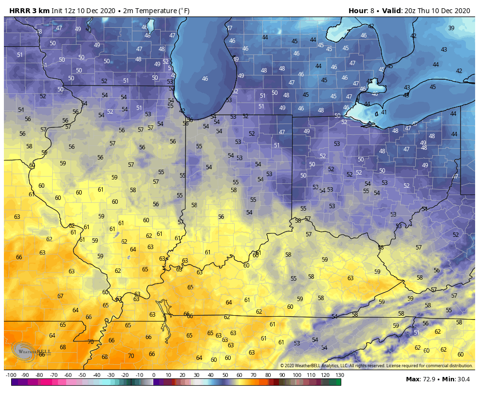
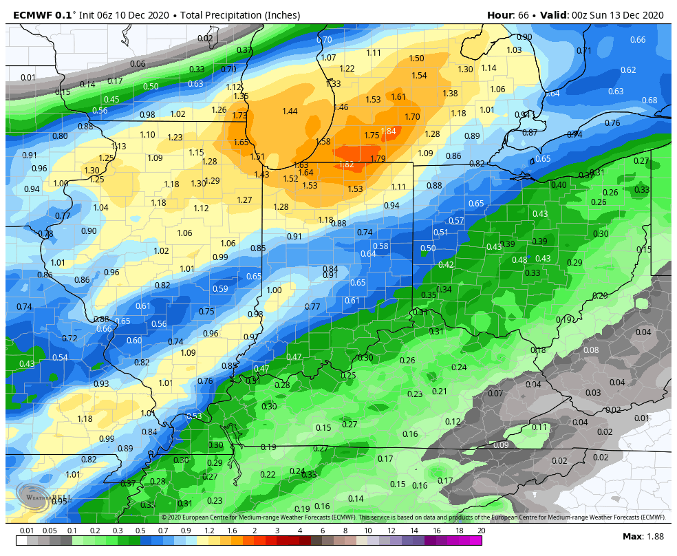
The pattern over the upcoming week will feature a “transient” flavor. The warmth of present will take a backseat to renewed chilly air (nothing unusual for this time of year) early next week behind the passage of a cold front. Speaking of, it still appears as if rainfall amounts should be within 0.50″ to 0.75″ (locally heavier totals) for most Saturday with the passage of the frontal boundary. Widespread heavier amounts of an inch, or more, can be expected across northern IN.
Another system will present itself the middle of next week. With colder air in place, there could be a wintry mix across a portion of the region Tuesday night into Wednesday. We’ll keep an eye on this feature and let our short-term products drill in with more specifics.
The primary purpose of this post is to look ahead to the longer range period, and that includes the all-important early Christmas idea. To start, we always like to look at a blend of the teleconnections and MJO. Interestingly, the teleconnections have been trending towards a colder pattern, overall, for mid and late month (at least when compared to a week, or so, ago). Of note, the AO and NAO are forecast strongly negative which increases the likelihood of high latitude blocking. The outlier? The EPO. Though not forecast as strongly positive as in previous days, the slightly positive EPO favors more of an eastern ridge. Overall, the AO, NAO, and “neutral” PNA outweigh the positive EPO.

The MJO is largely forecast to remain in the “null” phase over the coming few weeks. This suggests we need to lean heavier on the teleconnection trends above (at least until the MJO finally wants to become more amplified). Note how the MJO does “sneak” into Phase 5 briefly in the short-term. Interestingly, this is also associated with the warmth over the coming 7-day period.


So what happens beyond this point? The trends of the stronger negative NAO and AO are beginning to increase confidence that we’re going to be looking at a much more active 2nd half of the month. High latitude blocking usually likes to force the storm track further south, leading to, at times, lengthy periods of active, stormy weather. The positive EPO will be dealt with from time to time and is holding us back from going “overly” cold, compared to normal, for late month. From this distance, what we feel is more likely to happen is that our temperature pattern is closer to average or slightly above, but with a very active storm track through the end of the month. That more active period actually gets going this weekend. At times, wintry threats are likely to emerge, even with marginally cold air. That said, we don’t envision colder than normal temperatures locking in for any sort of length of time between and the end of the year.
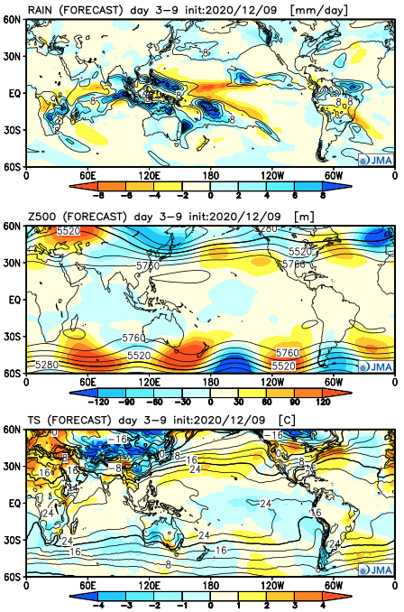
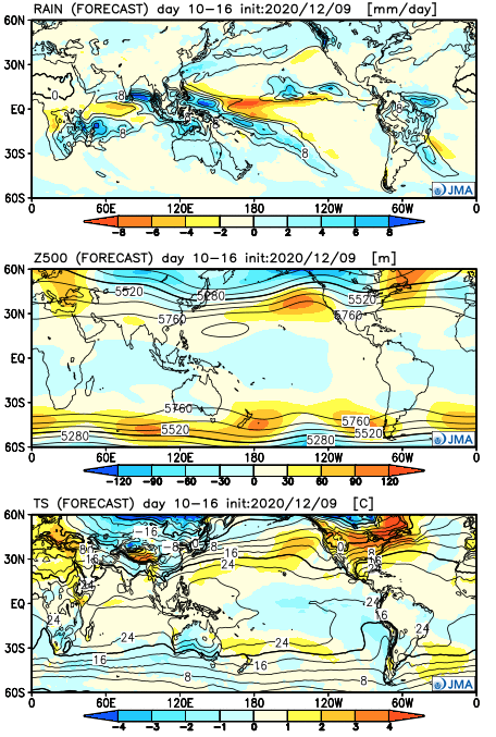
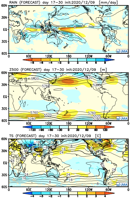
Let’s take a look at the updated JMA Weeklies. Given the forecast upper air pattern, one would assume the model may be overly warm through the period (after Week 1). The active times are shown nicely.
Week 1
Week 2
Weeks 3-4
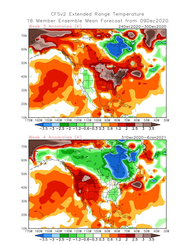
The latest CFSv2 Weeklies show the warmer Week 3 forecast (Christmas Eve-Dec. 30) giving way to a period of cooler air Week 4 (New Year’s Eve-1st week of Jan).
We’ll review the new European Weeklies this evening in our video update. Make it a great Thursday!
Permanent link to this article: https://indywx.com/2020/12/10/long-range-update-christmas-period-comes-into-view/
Dec 09
VIDEO: Sunshine Returns; Mid-December Chatter…
Sunshine and milder weather can be expected as we move through midweek. A developing storm system will push rain back into the region over the weekend. More on this and…
You must be logged in to view this content. Click Here to become a member of IndyWX.com for full access. Already a member of IndyWx.com All-Access? Log-in here.
Permanent link to this article: https://indywx.com/2020/12/09/video-sunshine-returns-mid-december-chatter/
Dec 08
VIDEO: Welcoming In A Much More Active Weather Pattern Through Mid-December…
The days of not having much to track on the local weather charts are about to be long gone. The pattern has a look that will yield a much more…
You must be logged in to view this content. Click Here to become a member of IndyWX.com for full access. Already a member of IndyWx.com All-Access? Log-in here.
Permanent link to this article: https://indywx.com/2020/12/08/video-welcoming-in-a-much-more-active-weather-pattern-through-mid-december/
Dec 07
VIDEO: Not That There Isn’t Chill Available, But Sustainability Is Severely Lacking. We Explain Why…
It’s not that there isn’t any cold to speak of, but instead the lack of sustained chill moving ahead. This morning, we discuss why we believe that is with the…
You must be logged in to view this content. Click Here to become a member of IndyWX.com for full access. Already a member of IndyWx.com All-Access? Log-in here.
Permanent link to this article: https://indywx.com/2020/12/07/video-not-that-there-isnt-chill-available-but-sustainability-is-severely-lacking-we-explain-why/
Dec 06
VIDEO: Chilly Open To The Week Before We Make A Push For 60° By Late Week…
We’re tracking an upper level disturbance that should have just enough moisture available to squeeze out a couple of snow flurries and scattered snow showers this evening and Monday. This…
You must be logged in to view this content. Click Here to become a member of IndyWX.com for full access. Already a member of IndyWx.com All-Access? Log-in here.
Permanent link to this article: https://indywx.com/2020/12/06/video-chilly-open-to-the-week-before-we-make-a-push-for-60-by-late-week/
Dec 05
VIDEO: Reinforcing Chilly Air Arrives To Open The Work Week; Questions Abound Next Weekend…
Reinforcing chilly air arrives to open the work week. We continue to monitor the potential of a more significant storm next weekend, but details are murky at best…
You must be logged in to view this content. Click Here to become a member of IndyWX.com for full access. Already a member of IndyWx.com All-Access? Log-in here.
Permanent link to this article: https://indywx.com/2020/12/05/video-reinforcing-chilly-air-arrives-to-open-the-work-week-questions-abound-next-weekend/
