
You must be logged in to view this content. Click Here to become a member of IndyWX.com for full access. Already a member of IndyWx.com All-Access? Log-in here.
December 12, 2020 archive
Permanent link to this article: https://indywx.com/2020/12/12/video-fresh-thoughts-on-both-tuesday-night-wednesday-and-the-overall-pattern-through-the-holidays/
Dec 12
Client Brief: Eyeing 1st Widespread Accumulating Snow Of The Season…
Type: Impactful wintry weather
What: Accumulating snow
When: Tuesday night & Wednesday
Temperatures: Lower 30s
Wind: NE 10-20 MPH early in the event, shifting to the NW and decreasing to 5-10 MPH Wednesday
Blowing/ Drifting: Minimal
Pavement Impacts: Salting and plowing required
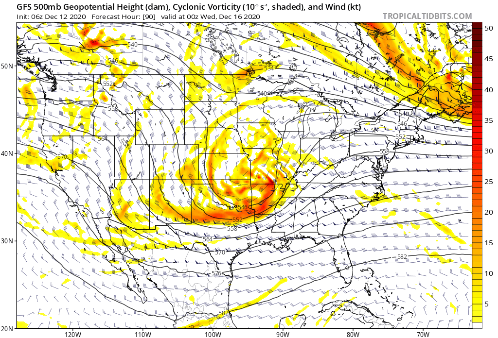
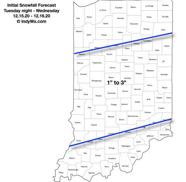
Summary: An area of low pressure will move across northern Texas (Monday night and Tuesday morning) northeast into the lower Ohio Valley (Wednesday morning). In response to this feature, a secondary surface low will form in the northern Gulf of Mexico Tuesday night and it’s this surface low that will eventually “steal the show” moving northeast and being located off the Carolina coast Wednesday before eventually blowing up into a good ole fashioned nor’easter Wednesday night and Thursday. Before this energy transfer takes place, we should see a stripe of accumulating snow extend northeast into the Ohio Valley Tuesday night and Wednesday. From this distance, it appears as if central IN is in store for the 1st widespread snow event of the season, but the devil’s still in the details. We’ll have to monitor the energy transfer closely. Additionally, it’ll be important to keep eyes on the developing Gulf low. Should this system generate convection in more rapid fashion than currently thought, it would steal some of the moisture from the initial low into the OHV. As it is, the early thinking here is that this is a 1″ to 3″ type event for our immediate region. Should the Gulf low organize a little slower, the possibility is there for heavier totals. Widespread snow should diminish and come to an end late Wednesday morning (west) and by afternoon (east). Thursday and Friday look dry and cold.
Confidence: Medium
Next Update: This afternoon (video package)
Permanent link to this article: https://indywx.com/2020/12/12/client-brief-eyeing-1st-widespread-accumulating-snow-of-the-season/