
You must be logged in to view this content. Click Here to become a member of IndyWX.com for full access. Already a member of IndyWx.com All-Access? Log-in here.
December 30, 2020 archive
Permanent link to this article: https://indywx.com/2020/12/30/video-short-term-update-on-flip-to-wet-snow-this-evening-and-freezing-rain-nyd-morning/
Dec 30
12.30.20 Weather Bulletin: Timing Out Period Of Wet Snow By Evening; Icy Glaze To Open New Year’s Day…

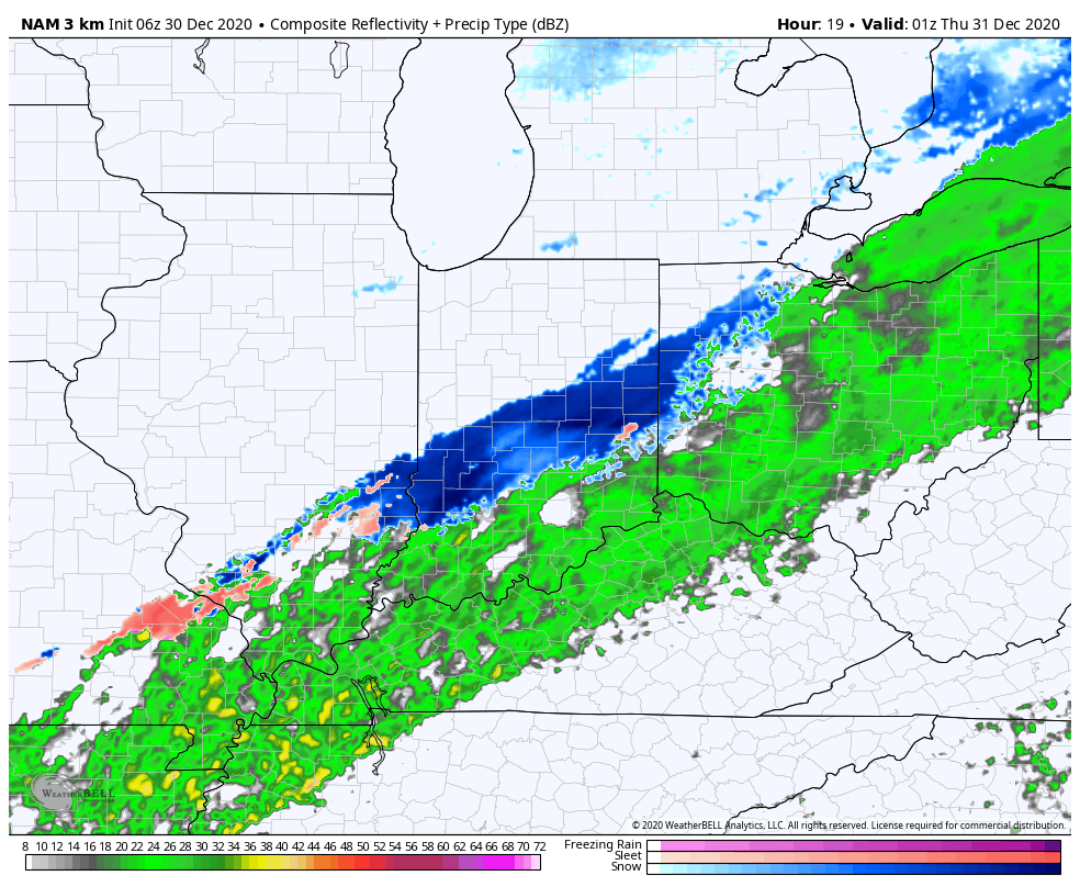
Rain Ends As Wet Snow This Evening…A cold rain will continue to overspread central Indiana this morning. A cold front will slip south across the state through the afternoon and temperatures will fall into the 30s prior to sunset across most of the region. One final wave of moisture will push northeast across the area as temperatures fall into the low and mid 30s leading to a brief period of wet snow between 6p and 10p (northeast to southwest). We’re likely only looking at a window of 1-2 hours of snow at any one location, but it could fall moderate to heavy during that brief window and accumulate between a dusting and 1.5″. We’ll keep an eye on model trends through the day.
New Year’s Eve will feature dry, but gloomy and cold conditions. Look for overcast skies and highs struggling to make it to freezing.
Our second area of low pressure will lift north from the northwestern Gulf Coast into the Midwest Friday and Saturday. This will help widespread precipitation overspread the Hoosier state New Year’s Day (before sunrise for most). With cold air locked in at the surface, precipitation at the onset, continuing for a few hours north of a line from Terre Haute, Bloomington, and Cincinnati, will fall as freezing rain. If traveling early, we’d recommend caution as a light icy glaze (less than .10″ for most) is a good bet. Eventually warmer air will win out, switching things to a “plain ole rain” late morning into the afternoon.
Lingering showers will end Saturday as a trailing piece of upper level energy moves east across the Ohio Valley. Dry skies will return as we open up the new work week.
Permanent link to this article: https://indywx.com/2020/12/30/12-30-20-weather-bulletin-timing-out-period-of-wet-snow-by-evening-icy-glaze-to-open-new-years-day/
Dec 30
Rain Ends As Snow This Evening; Freezing Rain Transitions To Rain New Year’s Morning…
Rain is on the move east early this morning and should overspread most of central Indiana prior to sunrise or shortly after.

Highs will top out in the mid-upper 40s this afternoon before beginning to fall into the 30s by late afternoon. Guidance has also begun to trend more bullish on a narrow band of wet snow developing across central Indiana around, or just after, sunset as the colder air filters into the region. For now, we’ll target between 6p and 10p for the changeover to wet snow across central Indiana. While we’re still not forecasting significant snowfall, a quick 1”-2” isn’t out of the question before drier air builds in by mid to late evening. We’ll continue to keep a close eye on things.
New Year’s Eve will feature a cloudy, cold, but dry day. Our secondary area of low pressure will lift north New Year’s Day, spreading moisture back into the state. Cold air will be entrenched early and allow this precipitation to take the form of freezing rain predawn Friday, continuing for a few hours before switching over to plain ole rain. Before this transition takes place, a light glaze (.1 or less) is possible across most of central Indiana (mainly along and north of a Terre Haute to Bloomington to Cincinnati line).

I’m still working on getting a video uploaded from the road. Fingers are crossed I’ll have success later this morning. Make it a great Wednesday!
Permanent link to this article: https://indywx.com/2020/12/30/rain-ends-as-snow-this-evening-freezing-rain-transitions-to-rain-new-years-morning/