
You must be logged in to view this content. Click Here to become a member of IndyWX.com for full access. Already a member of IndyWx.com All-Access? Log-in here.
April 2019 archive
Permanent link to this article: https://indywx.com/2019/04/30/short-term-video-update-muggy-with-strong-storms-at-times/
Apr 30
All-Access Video Update: Wet; Active Pattern Continues Into Next Week…
Good morning, friends! This morning’s video takes a deeper look at the overall pattern and drivers behind the active and wetter than normal weather pattern. Unfortunately, this overall wet regime…
You must be logged in to view this content. Click Here to become a member of IndyWX.com for full access. Already a member of IndyWx.com All-Access? Log-in here.
Permanent link to this article: https://indywx.com/2019/04/30/all-access-video-update-wet-active-pattern-continues-into-next-week/
Apr 29
Muggy Meter Goes Up Into Midweek; Timing Out Periods Of More Concentrated Showers And Storms…
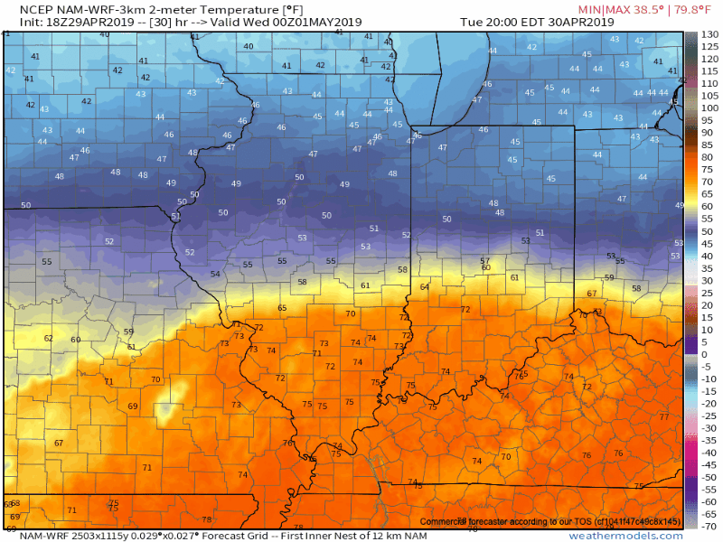
A frontal boundary remains draped across central Indiana and will remain in place through Tuesday evening before lifting north as a warm front. A large temperature spread can be expected on either side of this frontal boundary tomorrow (40s and 50s north of the front to near 80 south of the boundary). More specific to Indianapolis, itself, it’s very possible temperatures may vary by as much as 10-15 degrees from northern and southern ‘burbs tomorrow afternoon.

Before the front lifts north as a warm front, a ripple of energy will move along the boundary Tuesday morning, helping to lead to more concentrated shower and thunderstorm activity before sunrise.
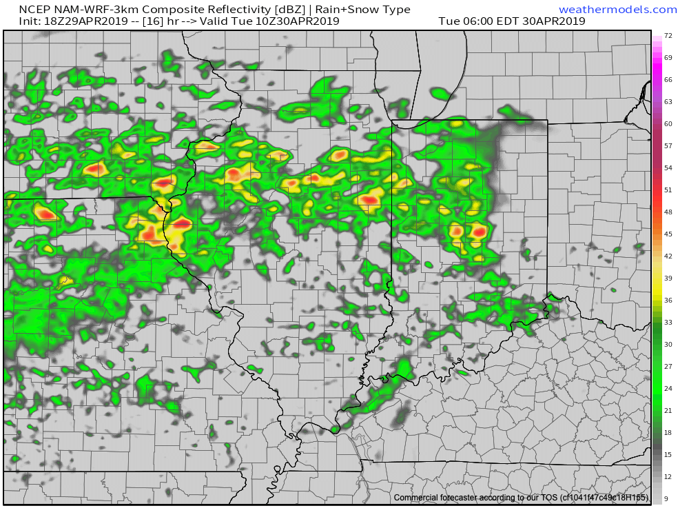
Showers and thunderstorms will remain in our forecast Tuesday afternoon into the evening hours, especially for western and northern parts of the region. As the warm front lifts north, we’ll notice a significantly warmer and increasingly moist air mass Tuesday night into the day Wednesday.
Guidance suggests additional rainfall amounts between now and Wednesday night will check in between 0.50″ and 1″ for the majority of central Indiana, with heavier amounts of 1″ to 3″ for northern Indiana.
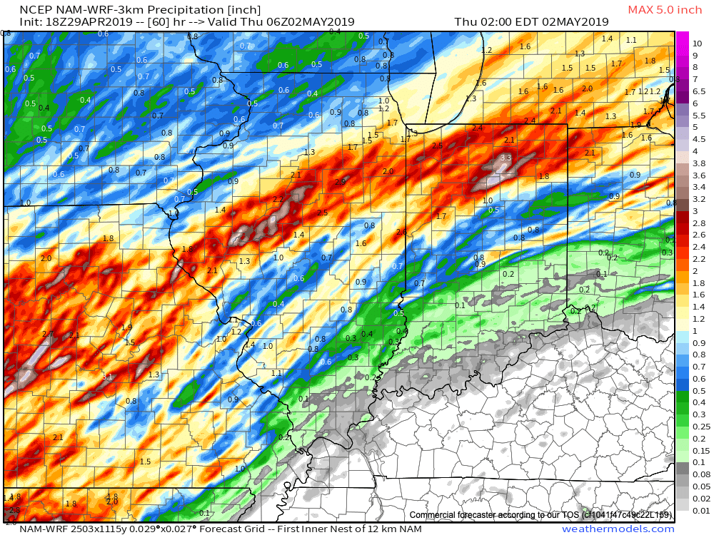
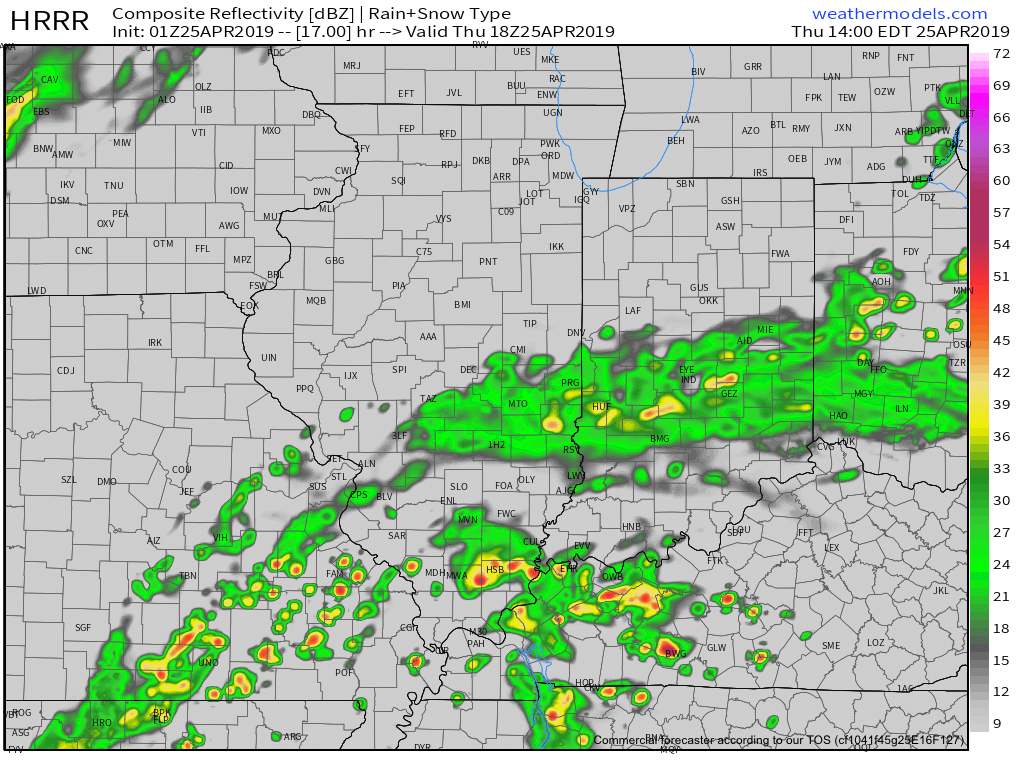
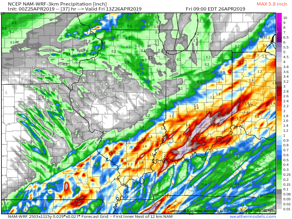
A couple of additional disturbances will move northeast across the region as we close out the work week and head into the weekend. As such, we expect additional periods of more widespread shower and thunderstorm activity to occur Thursday (image 1 below) and Friday evening into the first part of Saturday (especially across the southern half of the state- image 2 below).
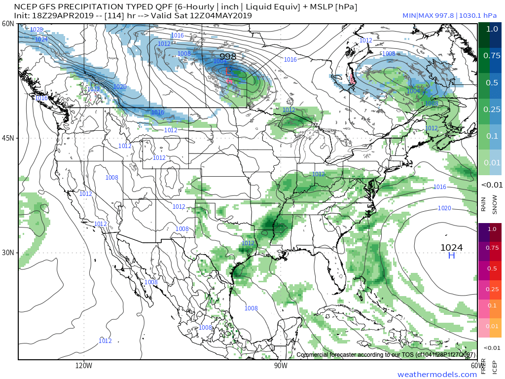
Guidance as of Monday evening suggests central Indiana could accumulate an additional 0.50″ to 1″ in the Thursday through Saturday period with locally heavier amounts.
Looking longer term, after what should be a dry close to the weekend, rain and storms quickly return to the picture during the early parts of next week…
Permanent link to this article: https://indywx.com/2019/04/29/muggy-meter-goes-up-into-midweek-timing-out-periods-of-more-concentrated-showers-and-storms/
Apr 29
VIDEO: Unsettled Week Takes On An Increasingly Muggy Feel…
You must be logged in to view this content. Click Here to become a member of IndyWX.com for full access. Already a member of IndyWx.com All-Access? Log-in here.
Permanent link to this article: https://indywx.com/2019/04/29/video-unsettled-week-takes-on-an-increasingly-muggy-feel/
Apr 28
VIDEO: Unsettled Week Ahead; Reviewing Our May Outlook…
You must be logged in to view this content. Click Here to become a member of IndyWX.com for full access. Already a member of IndyWx.com All-Access? Log-in here.
Permanent link to this article: https://indywx.com/2019/04/28/video-unsettled-week-ahead-reviewing-our-may-outlook/
Apr 27
Finalized May Outlook: One Word? Volatile
Averages for May are as follows:
*High: 72.8
*Low: 52.6
*Rainfall: 5.05″
*Snowfall: Trace
When all is said and done, this is how we see the last month of meteorological spring shaping up:


Medium and longer range guidance has been anything but consistent over the past few weeks for May, which doesn’t help in producing a monthly outlook. A large part of this may have to do with the renewed hyperactive MJO.

This can lead to volatile swings in the overall pattern as we get into the mid to late part of the month. Early on, confidence is higher in a “battle” setting up between late season anomalous cold across the north and budding summer-like warmth across the south.
This will help add fuel to the fire in what should be an overall wet month across a large portion of the country.
With that said, we think ridging is likely to keep the extreme southeastern region drier than normal for the bulk of the month.
As we look towards mid-May, that battle between southeastern ridging and troughiness across the northern region continues to argue for active times remaining.
Speaking more specific to central IN and the greater OHV region overall, we think a cooler and wetter than normal month awaits. Unfortunately, delays are likely to continue from an agriculture/ Plant ’19 perspective…
Permanent link to this article: https://indywx.com/2019/04/27/finalized-may-outlook-one-word-volatile/
Apr 26
VIDEO: Walking Through The Weekend; Flood Threat High Next Week…
You must be logged in to view this content. Click Here to become a member of IndyWX.com for full access. Already a member of IndyWx.com All-Access? Log-in here.
Permanent link to this article: https://indywx.com/2019/04/26/video-walking-through-the-weekend-flood-threat-high-next-week/
Apr 25
Special Evening Video Update On Next Week’s Flood Threat…
You must be logged in to view this content. Click Here to become a member of IndyWX.com for full access. Already a member of IndyWx.com All-Access? Log-in here.
Permanent link to this article: https://indywx.com/2019/04/25/special-evening-video-update-on-next-weeks-flood-threat/
Apr 25
VIDEO: Heavy Rain Moves In This Afternoon & Evening; Very Wet Pattern To Open May…
You must be logged in to view this content. Click Here to become a member of IndyWX.com for full access. Already a member of IndyWx.com All-Access? Log-in here.
Permanent link to this article: https://indywx.com/2019/04/25/video-heavy-rain-moves-in-this-afternoon-very-wet-pattern-to-open-may/
Apr 24
Wetter Trends…
The relatively quiet stretch of weather of the past several days has been nice. Unfortunately, as attention shifts to what lies ahead, quiet times are limited. Even in the short term, guidance has trended significantly wetter with the Thursday PM-Friday AM period, and longer term the story remains focused on heavy rain next week.
Tomorrow morning’s post will focus more on the longer range pattern, but tonight we wanted to provide a quick update on the storm system set to arrive tomorrow into Friday morning.

A few showers will be around the I-70 corridor tomorrow morning, but these shouldn’t be a huge deal and coverage will remain scattered in nature.
That begins to change as we move into Thursday afternoon with more widespread rain and some embedded moderate to heavy showers anticipated.
Thereafter, widespread rain should continue into early Friday morning. The axis of heavy rain has trended much further NW when compared to even this morning. Now, most guidance brings the 1” totals as far north as the Indianapolis region. Lighter amounts will be seen northwest of the city.
We still think rain will come to an end Friday morning and we should introduce an increasingly sunny sky as we get set to wrap up the work week.
Much more in the AM on what lies ahead over the weekend into next week…
Permanent link to this article: https://indywx.com/2019/04/24/wetter-trends/