March 2019 archive

All-Access Video: Week-Ahead Outlook; More Sustained Spring Pattern Just Around The Corner…

You must be logged in to view this content. Click Here to become a member of IndyWX.com for full access.  Already a member of IndyWx.com All-Access?  Log-in here.

Permanent link to this article: https://indywx.com/2019/03/31/all-access-video-week-ahead-outlook-more-sustained-spring-pattern-just-around-the-corner/

VIDEO: Period Of Wet Heavy Snow This Evening; Looking Ahead To Next Week…

You must be logged in to view this content. Click Here to become a member of IndyWX.com for full access.  Already a member of IndyWx.com All-Access?  Log-in here.

Permanent link to this article: https://indywx.com/2019/03/30/video-period-of-wet-heavy-snow-this-evening-looking-ahead-to-next-week/

Heavy Rain Ends As Snow This Evening…

A wet day is in store for central Indiana as a wave of low pressure moves along a stalled frontal boundary this afternoon. Once that low scoots by, the front will get a shove to the southeast and much drier weather will return as we go through the 2nd half of the weekend. The transition in between will be a combination of heavy rain eventually ending as wet snow this evening. Let’s time things out:

This morning’s initial wave of steady rain is now pushing into Ohio (as we write this just before 9a). Scattered showers are left behind.

That said, another wave of steady and, at times, heavy rain will return early this afternoon. A couple of thunderstorms are possible across southern Indiana.

Precipitation coverage will be widespread from noon until around 8p, including additional rainfall amounts over 1″ in many spots across central Indiana. Localized ponding and low-land flooding will be a good bet this afternoon into the evening hours.

As the area of low pressure scoots to our east, it’ll help pull the cold front south through central Indiana during the mid to late evening hours. Accordingly, rain will transition to a period of wet snow between 6p and 8p across central Indiana. More specific to Indianapolis, we think rain will switch to snow around 7p.

While snow won’t last a long time and temperatures will be above freezing as the snow is falling, briefly heavy intensity will likely result in a quick wet coating to around an inch in spots from central parts of the state, including east-central Indiana.

All precipitation will exit the state before midnight. While we could have a couple of scattered snow showers early Sunday morning, most of the day will be dry with increasing amounts of sunshine as the day progresses. It’ll be much colder with highs not making it out of the 30s.

Improving weather conditions will build in here through the early parts of the work week, along with moderating temperatures, thanks to high pressure. – Much more on the week ahead and longer range later today with our PM video update.

Permanent link to this article: https://indywx.com/2019/03/30/heavy-rain-ends-as-snow-this-evening/

Friday Morning Video: Wet Open To The Weekend; Cold Finish. Looking Ahead To A Changeable April Pattern…

You must be logged in to view this content. Click Here to become a member of IndyWX.com for full access.  Already a member of IndyWx.com All-Access?  Log-in here.

Permanent link to this article: https://indywx.com/2019/03/29/friday-morning-video-wet-open-to-the-weekend-cold-finish-looking-ahead-to-a-changeable-april-pattern/

Thursday Evening Video: Wet Open To The Weekend Before A Cold Finish; Reviewing The New JMA Weeklies…

You must be logged in to view this content. Click Here to become a member of IndyWX.com for full access.  Already a member of IndyWx.com All-Access?  Log-in here.

Permanent link to this article: https://indywx.com/2019/03/28/thursday-evening-video-wet-open-to-the-weekend-before-a-cold-finish-reviewing-the-new-jma-weeklies/

Finalized April Outlook…

Averages for April are as follows:

*High: 63.4

*Low: 42.7

*Rainfall: 3.81″

*Snowfall: 0.2″

By the time all is said and done, this is how we see April shaping up:

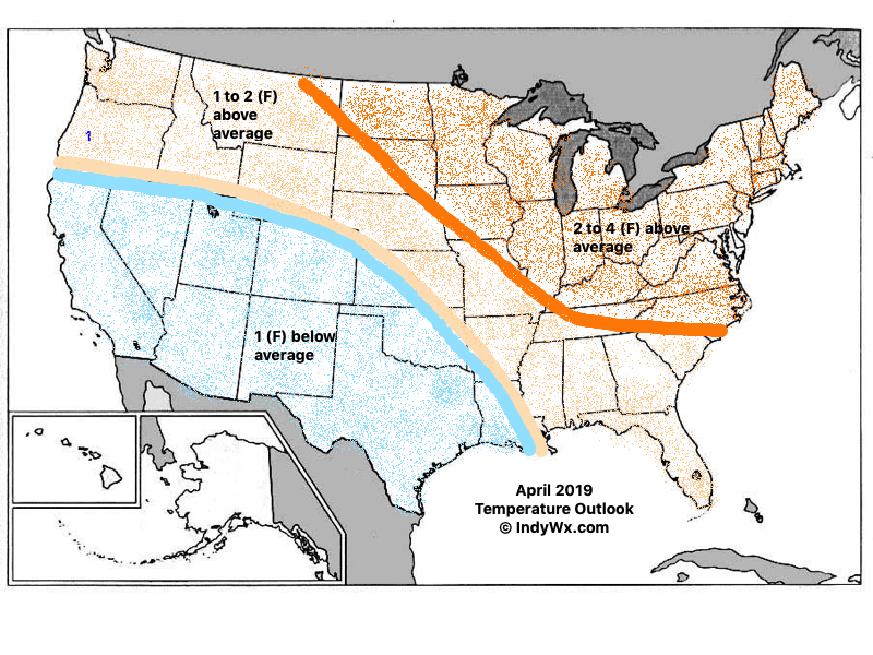
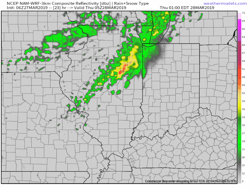
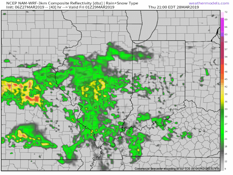
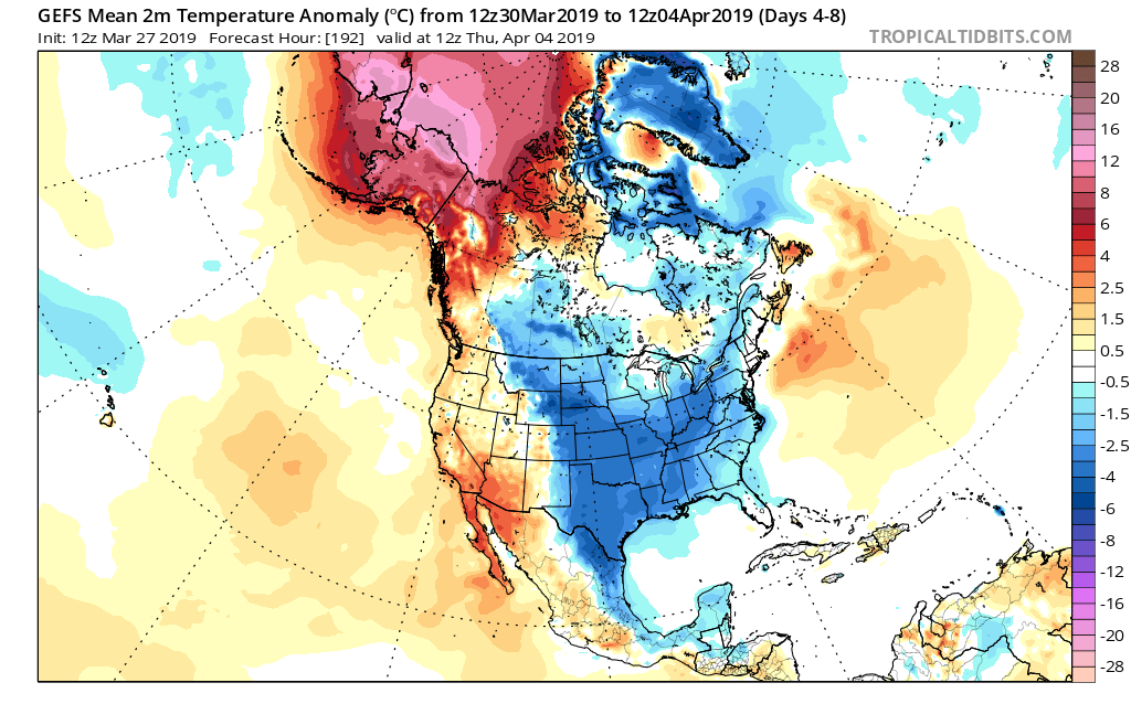
Modeling continues to show April opening cooler than normal and we agree that this will be the case, including a wetter than normal pattern, as well.

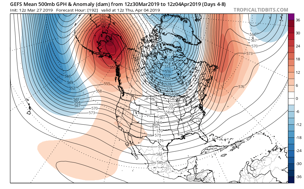
With that said, the persistent AK ridge begins to break down by the 2nd week of the month. This will lead to the early month chill being transient in nature and a significant flip to warmer than normal conditions during said timeframe, as well.

Note by the middle part of the month, a ridge is now forecast to be in the exact position the ‘mean’ trough position will locate itself for early month.

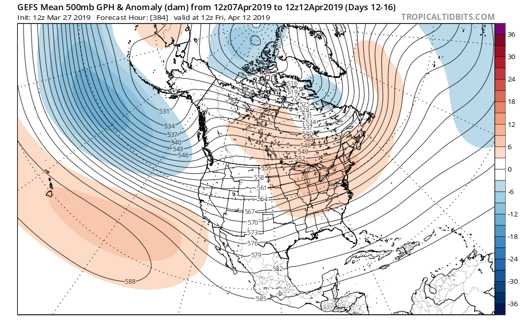
To no shock, it’s a vastly different temperature profile, as well. Now above normal warmth dominates. It’s easy to argue the model may not be warm ‘enough’ by this time over the OV and Northeast, with cooler anomalies across the SW.

The active pattern to open the month is expected to “settle down” for mid and late month as an upper level ridge dominates.

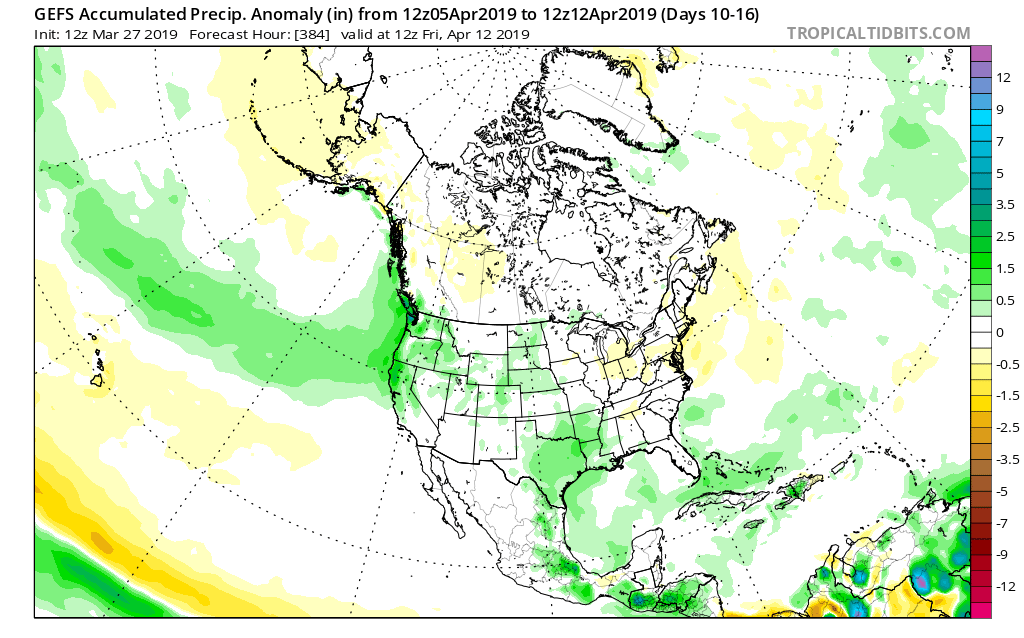
While the first week of April will likely run cooler and wetter than average, a rather significant flip in the pattern will result in drastically improved weather around these parts by mid and late April. By the time we get to month’s end, we think drier than normal conditions will rule across the northern Plains with warmer than average weather taking up shop across the Ohio Valley. A corridor of wetter than normal conditions is expected across the Intermountain West into the Lower MS River Valley.

Permanent link to this article: https://indywx.com/2019/03/27/finalized-april-outlook/

Heavy Rain Event To Wrap Up The Week…

Today will feature another day of gorgeous weather, including plentiful sunshine and warmer temperatures! After another frosty start, highs this afternoon will reach the middle 50s. Enjoy it as weather conditions will begin to deteriorate as we wrap up the week.

Scattered showers will arrive tomorrow, but these won’t really be a big deal. The bigger story will be gusty southwest winds and temperatures that top out in the lower 60s.

The first of a couple rounds of heavier rainfall will arrive Thursday night into Friday morning.

A cold front will remain draped over the region into Saturday before getting a “nudge” south Saturday night. This will serve as the focal point for additional rounds of rain Friday night into Saturday.

While precipitable water values won’t be overly “juicy” they will be sufficient enough to result in moderate to locally heavy rainfall at times.

A widespread soaking of 1″ to 2″ is a good bet by the time high pressure returns Sunday.

Permanent link to this article: https://indywx.com/2019/03/27/heavy-rain-event-to-wrap-up-the-week/

All-Access Video: Wet Open To The Weekend On The Way; Changeable Pattern For The 1st Half Of April…

You must be logged in to view this content. Click Here to become a member of IndyWX.com for full access.  Already a member of IndyWx.com All-Access?  Log-in here.

Permanent link to this article: https://indywx.com/2019/03/26/all-access-video-wet-open-to-the-weekend-on-the-way-changeable-pattern-for-the-1st-half-of-april/

Gorgeous Stretch Of Weather Through Midweek; Weekend Turns Unsettled…

High pressure will supply absolutely beautiful weather around these parts through Wednesday. Look for plentiful sunshine along with moderating temperatures.

While mornings will be chilly, afternoon highs will begin to rise. We’ll be near 50 this afternoon, mid to upper 50s Wednesday, and lower 60s Thursday.

A gusty southwesterly wind will not only push those warmer temperatures into the region, but moisture will also be on the increase. Scattered showers will return to the forecast Thursday afternoon before steadier rain arrives Friday into Saturday as a cold front sags south through the region. A couple thunderstorms are also possible.

By the time all is said and done Sunday morning, widespread 1″+ rainfall totals are expected with this storm system across central Indiana. Locally heavier totals can be expected.

High pressure will support a drier close to the upcoming weekend, but temperatures will be much colder.

Permanent link to this article: https://indywx.com/2019/03/26/gorgeous-stretch-of-weather-through-midweek-weekend-turns-unsettled/

Long Range Video Update: April Opens Stormy And Colder Than Normal…

It’s quiet now, but a very active and stormy pattern will get underway as we head into the weekend. This busy weather pattern will continue to rule the day into…

You must be logged in to view this content. Click Here to become a member of IndyWX.com for full access.  Already a member of IndyWx.com All-Access?  Log-in here.

Permanent link to this article: https://indywx.com/2019/03/25/long-range-video-update-april-opens-stormy-and-colder-than-normal/

IndyWx.com