May 2019 archive

Gusty Storms Blow Into Town Saturday PM…

The Storm Prediction Center has pulled the “Slight” Risk area more into Indiana with their most recent update for Saturday and we believe this may encompass more of the immediate area with subsequent updates.

The biggest concern has to do with straight line wind potential with one, or multiple lines of storms that will rumble through the state Saturday afternoon and evening.

The day will dawn bright and sunny with pleasant temperatures, but as the morning gives way to afternoon, conditions will destabilize and we’ll have our eyes focused to the northwest for thunderstorm initiation early afternoon across northern Indiana and Illinois. We then anticipate these individual storms to morph into a couple of lines of storms and push south into central Indiana during the mid and late afternoon/ early evening hours.

If you have outdoor plans tomorrow, please plan to have a means of receiving the latest information around potential severe thunderstorm watch/ warning information that may be required.

The 2nd half of the weekend will include fantastic weather (drier, less humid, and cooler) that will carry us into the first couple of days of the work week!

Permanent link to this article: https://indywx.com/2019/05/31/gusty-storms-blow-into-town-saturday-pm/

VIDEO: Gusty Saturday Storms; Wet Pattern Returns Next Week After 3-Day Break…

You must be logged in to view this content. Click Here to become a member of IndyWX.com for full access.  Already a member of IndyWx.com All-Access?  Log-in here.

Permanent link to this article: https://indywx.com/2019/05/31/video-gusty-saturday-storms-wet-pattern-returns-next-week-after-3-day-break/

Short-Term Video Update: How Long Do Storms Last Tonight? Strong Storms Saturday PM?

You must be logged in to view this content. Click Here to become a member of IndyWX.com for full access.  Already a member of IndyWx.com All-Access?  Log-in here.

Permanent link to this article: https://indywx.com/2019/05/30/short-term-video-update-how-long-do-storms-last-tonight-strong-storms-saturday-pm/

VIDEO: Scattered Storms This Evening; Cooler Pattern To Open June…

You must be logged in to view this content. Click Here to become a member of IndyWX.com for full access.  Already a member of IndyWx.com All-Access?  Log-in here.

Permanent link to this article: https://indywx.com/2019/05/30/video-scattered-storms-this-evening-cooler-pattern-to-open-june/

June Outlook: Does The Wet Pattern Continue?

Averages for June are as follows:

  • Average Low: 62.1 (f)
  • Avearge High: 81.9 (f)
  • Average Rain: 4.25″
  • Average Snow: 0.00″

As we head to the 50-yard line of 2019 (already?!), we’re of the belief we’re looking at a cooler than normal month of June with close to average rainfall. Before we get into our reasoning of such, let’s look at a few snap shots of the latest data:

CFSv2

JMA

NMME

Though we can’t show it, the longer range European model paints a cool, wet picture from the south-central into the Plains and portions of the Northeast.

Given the analogs we’ve looked over with weak El Ninos along with similar MJO pulses, we’ve built a generally wet and cool June forecast nationally:

Ridging should support warmer than average conditions across the Southeast and Pacific Northwest, along with a rather widespread cooler than normal regime through the south-central Plains into the Great Lakes and New England. Unfortunately, we think wetter than normal conditions remain from the Delta into the central Plains. With that said, conditions seem more favorable for planting through a large portion of the OHV region.

Permanent link to this article: https://indywx.com/2019/05/29/june-outlook-does-the-wet-pattern-continue/

VIDEO: Storms Continue Today; Discussing MJO Influence As We Move Into Early June…

You must be logged in to view this content. Click Here to become a member of IndyWX.com for full access.  Already a member of IndyWx.com All-Access?  Log-in here.

Permanent link to this article: https://indywx.com/2019/05/29/video-storms-continue-today-discussing-mjo-influence-as-we-move-into-early-june/

No Rest For The Weary…

Active weather will continue as we move through mid and late week. A cold front currently north of the region will slowly move south into central Indiana before stalling out and lifting back north as a warm front Thursday. This will serve as a focal point for additional thunderstorm development over the next few days.

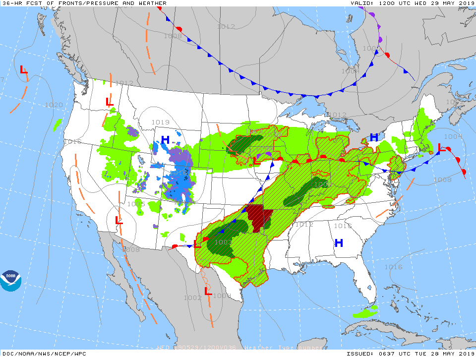
With a warm and moist environment in place, along with enough instability and forcing, storms may become strong to severe at times. While the setup the next couple of days doesn’t appear as favorable for tornadoes (when compared to yesterday), all modes of severe weather will be possible with the stronger storms. (Always have to be leery with a warm front nearby).

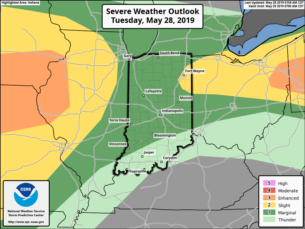
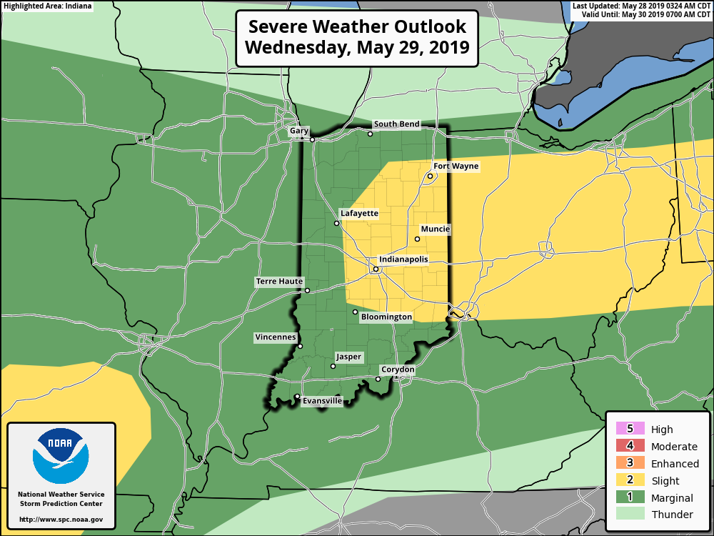
Periods of more concentrated storms can be expected this evening into Wednesday morning and again Wednesday evening into Thursday morning. In addition to a strong thunderstorm threat, locally heavy rain is a good bet.

There is hope that we will be able to work drier air into the region over the upcoming weekend, helping to reduce rain chances between Sunday and next Tuesday. Let’s keep our fingers crossed…

Permanent link to this article: https://indywx.com/2019/05/28/no-rest-for-the-weary/

VIDEO: Severe Weather Update…

You must be logged in to view this content. Click Here to become a member of IndyWX.com for full access.  Already a member of IndyWx.com All-Access?  Log-in here.

Permanent link to this article: https://indywx.com/2019/05/27/video-severe-weather-update/

VIDEO: All Modes Of Severe Weather Possible This Evening; Another Unsettled Week On Deck…

You must be logged in to view this content. Click Here to become a member of IndyWX.com for full access.  Already a member of IndyWx.com All-Access?  Log-in here.

Permanent link to this article: https://indywx.com/2019/05/27/video-all-modes-of-severe-weather-possible-this-evening-another-unsettled-week-on-deck/

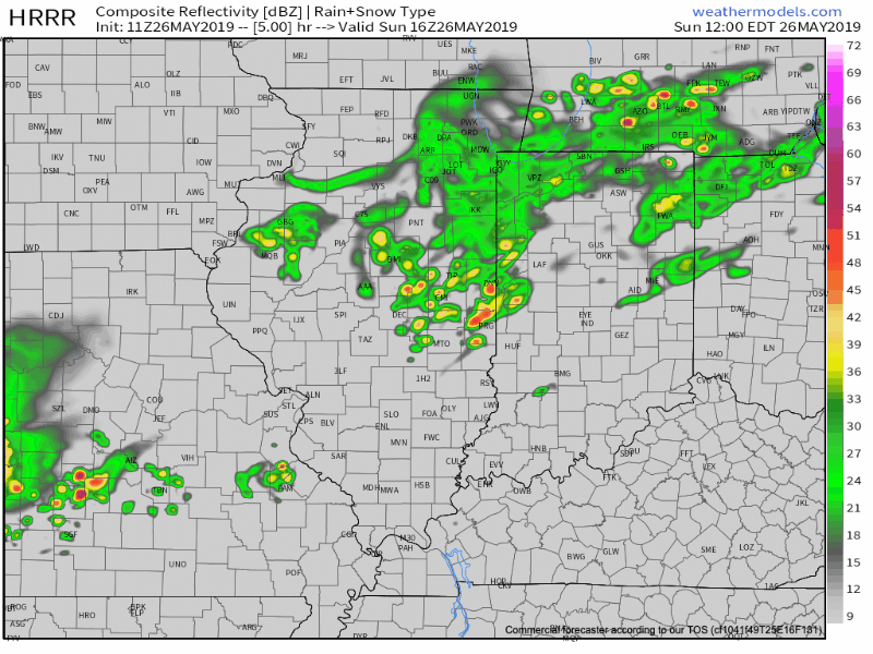
Stormy At Times For The Indy 500…

We’ve dealt with one round of showers and thunderstorms already this morning, but the bulk of the action remained north of the immediate area. Accordingly, there will be a greater chance of redevelopment this afternoon across central Indiana. A few of these storms could reach strong to severe levels with damaging winds and large hail the primary concern.

Don’t be surprised if future updates from the Storm Prediction Center (SPC) “pull” this Slight Risk area northward to include Indianapolis. Regardless, the ingredients are in place for a couple of severe cells this afternoon, locally, and it’ll be important to remain weather-aware.

While a shower is still possible this morning, thunderstorm coverage will likely increase in earnest between 1p and 4p. Locally heavy downpours and vivid lightning are a good bet with any storm that develops today.

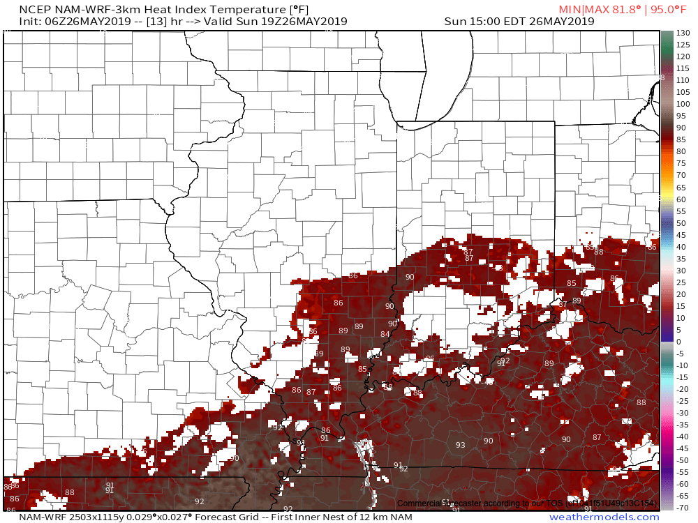
The other item race goers will have to deal with today will be the heat and humidity. Heat indices will flirt with 90 out at the track this afternoon.

Another active day is dialed up for Memorial Day, itself, across portions of the state. More on this and beyond in another update later today.

Permanent link to this article: https://indywx.com/2019/05/26/stormy-at-times-for-the-indy-500/

IndyWx.com