Updated 01.26.21 @ 9:40p
You must be logged in to view this content. Click Here to become a member of IndyWX.com for full access. Already a member of IndyWx.com All-Access? Log-in here.

Jan 26
Updated 01.26.21 @ 9:40p
You must be logged in to view this content. Click Here to become a member of IndyWX.com for full access. Already a member of IndyWx.com All-Access? Log-in here.
Permanent link to this article: https://indywx.com/2021/01/26/video-negative-ao-negative-pna-patterns-are-far-from-boring/
Jan 26
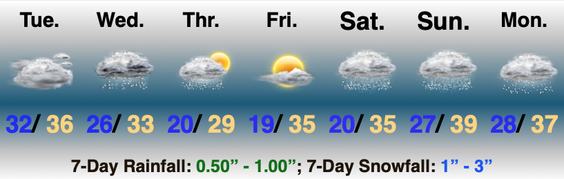
Updated 01.26.21 @ 8:09a
Socked In…Low clouds and areas of drizzle will remain with us for the better part of the day. As colder air filters back in this evening, a few flurries may mix with the drizzle as the moisture departs.
Our attention will then shift to upper level energy that will race east Wednesday and Wednesday night. This feature will skirt the southern portion of the state and squeeze out some light snow Wednesday afternoon and early evening. “Light” is the key word, but places from Vincennes over to Madison and points south could accumulate around an inch of snow. A dusting to half an inch may make it as far north as Bloomington and surrounding areas, but the lack of moisture, combined with forward momentum with this system will make it tough to get anything meaningful for most of the region.
Colder air will filter into the state Wednesday night and should be enough to fire up scattered snow showers for all into Thursday morning. Sunshine will return Friday (the “calm before the (bigger) storm”).
Saturday may open with early morning sunshine, but clouds will quickly thicken up and lower as low pressure heads this direction out of the central Plains. An overrunning event will ensue by Saturday afternoon. With cold air still entrenched, we’re talking about a big ole mix bag of sleet and snow to begin. This will require close attention as models have been trending colder as of late and the flavor of our weekend forecast will follow suit. The potential is there for several inches of snow/ sleet Saturday before precipitation possibly ends as drizzle Sunday morning. For now (especially given how the snow season has gone thus far) we’ll bracket for the possibility of 1″-3″, but just know this system has an upside. 🙂
Colder air will whip in here Sunday afternoon and Monday with wrap-around moisture ending as snow and snow showers. Stay tuned.
Permanent link to this article: https://indywx.com/2021/01/26/01-26-21-weather-bulletin-shot-of-southern-light-snow-bigger-weekend-event/