
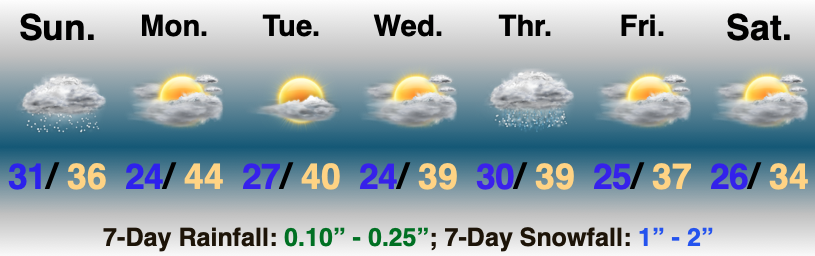
Temperatures Trend Colder Late Week…Upper level energy will scoot out of the region as quickly as it arrived and will take the snow with it. Look for snow to diminish from west to east through mid morning. Heaviest bands of the white stuff set up along and north of the I-70 corridor overnight. While the system tracked a tick further north than originally expected, northern portions of our 2”-4” zone should verify once all is said and done (please keep those reports coming). Southern portions (closer to the I-70 corridor) will bust on the low end. Improving weather conditions are dialed up through the 1st half of the new work week, including a return of the sun! (ENJOY)!
Our next system of note will arrive Thursday into early Friday. Operational guidance continues to struggle with handling of features beyond 3 days out (thanks in part to the maturing high latitude blocking pattern) and this feature will require our attention for the chance of a wintry mix of rain/ snow. Stay tuned as we fine tune!
Drier, colder weather is dialed up to head into next weekend. Enjoy the down time while you have it. A fairly active period of weather seems to loom on the horizon for mid and late month…
Thank you again for your patience with posts (along with video troubles) the past few days. We’ll be settled back into the home office Monday and will resume “regularly scheduled” programming at that time.