June 2019 archive

Long Range Update: Unseasonably Refreshing Pattern Set To Rule The Day…

A few days into June, Indianapolis is running half a degree below normal and 0.57″ below normal in the rainfall department.

Coolest anomalies have been focused over the Great Lakes region. A good portion of the region is running below average early on this month in the rainfall department, with the exception being the eastern Great Lakes.

As we look ahead, the MJO is forecast to move through Phases 3 and 4 with its eyes set on Phase 5 late month.

The relative “transient” warmth now lines up perfectly with Phase 3, but note the cooler pattern that Phase(s) 4-5 typically delivers.

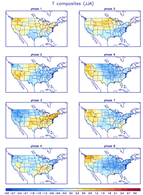
As a side note, there’s reason to believe this rather hyper MJO will continue, carrying us into the cooler Phases 6-8 as we move into the heart of the summer.

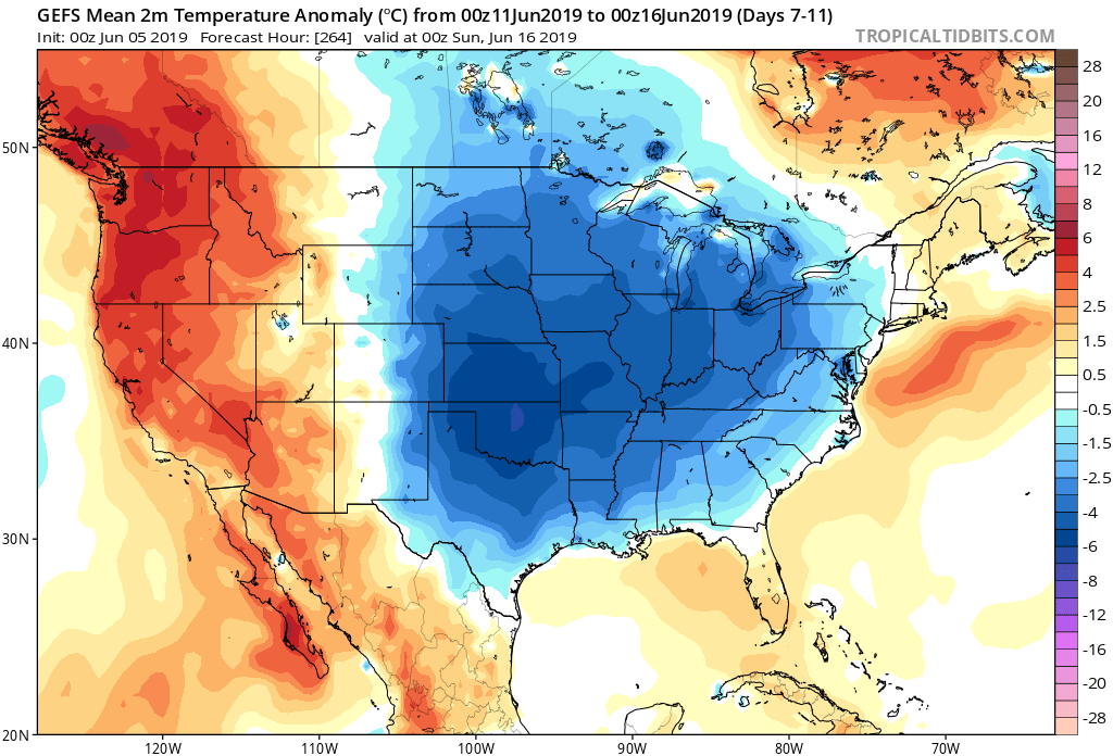
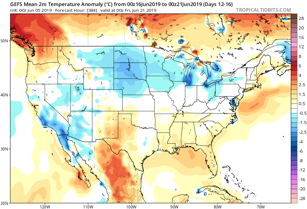
To no surprise, the medium and long range guidance is going towards a cooler than normal and unseasonably refreshing look as we move through the mid month period and into late June.

The Climate Forecast System agrees:

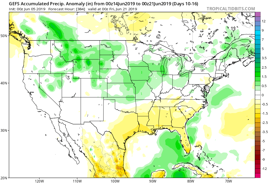
As for rainfall, we’ll use our short-term updates to handle the Weeks 1-2 period, but as we look ahead to mid-June, the pattern is expected to feature above normal rainfall across the Mid West and into the Ohio Valley and Great Lakes.

Permanent link to this article: https://indywx.com/long-range-update-unseasonably-refreshing-pattern-set-to-rule-the-day/

Evening All-Access Video: It’s Not All “Doom And Gloom;” Updated Thoughts Around Late Week-This Weekend…

You must be logged in to view this content. Click Here to become a member of IndyWX.com for full access.  Already a member of IndyWx.com All-Access?  Log-in here.

Permanent link to this article: https://indywx.com/evening-all-access-video-its-not-all-doom-and-gloom-updated-thoughts-around-late-week-this-weekend/

VIDEO: Detailed Look At The Pattern And Associated Heavy Rain Timing Into Early Next Week…

You must be logged in to view this content. Click Here to become a member of IndyWX.com for full access.  Already a member of IndyWx.com All-Access?  Log-in here.

Permanent link to this article: https://indywx.com/video-detailed-look-at-the-pattern-and-associated-heavy-rain-timing-into-early-next-week/

VIDEO: Unsettled Weather Returns After A Pleasant Open To The Work Week…

You must be logged in to view this content. Click Here to become a member of IndyWX.com for full access.  Already a member of IndyWx.com All-Access?  Log-in here.

Permanent link to this article: https://indywx.com/video-unsettled-weather-returns-after-a-pleasant-open-to-the-work-week/

Weekly #AGwx And Severe Weather Outlook…

Forecast Period: 06.02.19 through 06.09.19

7-Day Precipitation: Rainfall is expected to run above average through the period.

7-Day Temperatures: Above normal temperatures are expected through the period, mostly thanks to warmer than average overnight lows.

Severe Weather: We’ll remain quiet through early week before things begin to turn more active by midweek. The Storm Prediction Center is including the southern half of the region in a risk of severe weather by Wednesday (noted in the Day 4 Outlook below).

Summary: After a pleasant and quiet open to the period (today and Monday), thinks will begin to turn more active thereafter. Initially, it’ll take some time to “moisten” things up on Tuesday, but at the very least, light to moderate rain should work across central Indiana late Tuesday morning into the afternoon. Things will be fully saturated by Wednesday and periods of more concentrated rain, occasionally heavy, can be expected into the weekend. Unfortunately, guidance is in rather remarkable agreement of widespread 1.5″ to 2.5″ with locally heavier totals over the upcoming 7-day period.

Permanent link to this article: https://indywx.com/weekly-agwx-and-severe-weather-outlook/