July 2019 archive

Dry Open To August, But Then What?

There’s no question that August will open dry, quiet, and downright pleasant. A lot of this is thanks to a dominating ridge of high pressure that will essentially park itself over the Ohio Valley into the early part of next week. While we continue to keep eyes on the potential of a shower or storm Sunday (especially across northern IN), the pattern overall through the upcoming week looks bone dry.

There’s no reason to disagree with the latest ensemble/ climate data and associated dry pattern depicted on the latest runs into the middle of next week.

That said, there are some key changes that take place between the current upper air pattern and what awaits in the Weeks 2-3 time period shown below.

Note the placement of the upper ridge across the 4-corners region and the prevailing northwest flow aloft across the upper Midwest, Great Lakes, and Ohio Valley. This is the type pattern that should result in a rather significant “uptick” in storm systems traversing the region beginning late next week into the following week.

The latest Weeks 2-3 data is considerably different from present with respect to the overall precipitation pattern and we would agree this wetter idea has merit…

Moral of the story is that if you need to tend to significant outdoor projects over the upcoming 6-7 days, you’re in luck with an extended period of dry weather. However, we should thankfully avoid the prolonged hot, dry stretch that August can be notorious for around these parts with a significant shift towards a wetter pattern by Week 2.

Permanent link to this article: https://indywx.com/2019/07/31/dry-open-to-august-but-then-what/

VIDEO: Quiet; Pleasant Stretch Of Weather Into The Weekend…

You must be logged in to view this content. Click Here to become a member of IndyWX.com for full access.  Already a member of IndyWx.com All-Access?  Log-in here.

Permanent link to this article: https://indywx.com/2019/07/31/video-quiet-pleasant-stretch-of-weather-into-the-weekend/

Tuesday Morning Rambles: Tropics Turn More Active And More On The Cool 1st Half Of August…

I. Indianapolis officially register 0.68″ in the rain gauge Monday, however, there were many neighborhoods that reported over 1″ of rain. A snapshot of radar estimates below show between 1″ and 1.5″ of rain from places such as Crawfordsville up through Frankfort and towards Fort Wayne, along with areas in and around Connersville and Richmond. After a dry stretch, this rain sure was welcome!

II. Isolated to widely scattered thunderstorms will remain in the forecast today- especially across southeast portions of the state. From Indianapolis and points north, we’ll begin to really notice the drier air that will take hold later this evening.

Dew points will fall into the 50s and lower 60s across the northern half of the state by evening.

III. An extended stretch of dry, pleasant late summer weather is expected for the rest of the week and into the weekend, thanks to high pressure.

IV. The tropics will begin to turn more active over the upcoming 10 days. I think it’s the “follower” that we’ll need to pay close attention to as we get to the weekend and on into next week. Given the steering current, should this system develop, we’d likely be talking about a tropical storm sitting off the eastern FL or southeast coast early to middle next week.

V. Our August Outlook was posted last night and features an overall cooler than average month, locally. After a quiet week this week, a series of cold fronts will begin to impact our neck of the woods next week. Each front will deliver showers and embedded thunder along with unseasonably cool, pleasant air by early-August standards. More on the specifics here once we get closer!

Permanent link to this article: https://indywx.com/2019/07/30/tuesday-morning-rambles-tropics-turn-more-active-and-more-on-the-cool-1st-half-of-august/

All-Access Video: August Outlook…

You must be logged in to view this content. Click Here to become a member of IndyWX.com for full access.  Already a member of IndyWx.com All-Access?  Log-in here.

Permanent link to this article: https://indywx.com/2019/07/29/all-access-video-august-outlook/

VIDEO: T-storms Increase Today; “Hint” Of Fall Later Next Week…

You must be logged in to view this content. Click Here to become a member of IndyWX.com for full access.  Already a member of IndyWx.com All-Access?  Log-in here.

Permanent link to this article: https://indywx.com/2019/07/29/video-t-storms-increase-today-hint-of-fall-later-next-week/

Weekly AG And Severe Weather Update…

Forecast period: 07.28.19 through 08.04.19

7-Day Precipitation: Rainfall is expected to run below average through the forecast period.

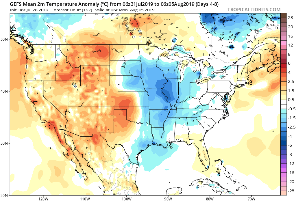
7-Day Temperature Outlook: Temperatures are expected to run slightly below average through the period.

Severe Outlook: While organized severe weather isn’t anticipated through the period, a few strong storms are possible across central Indiana Monday afternoon as a cold front moves into the region.

Summary: It’s generally going to be another quiet week of weather across not only central Indiana, but a large part of the Ohio Valley. A cold front will pass early Tuesday and this will help spark scattered to numerous showers and thunderstorms Monday afternoon and evening. Thereafter, mainly dry conditions are expected through the remainder of the week. As we look ahead to next week, that’s when things are expected to take on an increasingly “busy” regime (both with respect to cooler and wetter trends).

Permanent link to this article: https://indywx.com/2019/07/28/weekly-ag-and-severe-weather-update/

A Different Kind Of “Dog Days” This Year…

Late July and August have been known to produce some serious heat around these parts from time to time. However, it continues to look like this will not be the case this year.

We’ve already discussed the impacts of the negative EPO. (By the way, modeling continues to take the EPO even more strongly negative with every passing update). This supports the cooler idea we have for early August.

Now we see the PNA forecast to trend more positive through the better part of early August. This, too, supports the cooler pattern that will be with us through the period.

It should come as no surprise to see the models trend stronger with the eastern trough in the Weeks 2-3 time period. This period will likely feature a couple of strong frontal passages that serve as a reminder that the fall season is just around the corner.

Note the latest GEFS deepen the trough from the Day 5-10 period to Days 10-15.

Not only will this serve to provide a rather lengthy period of cooler than normal temperatures through the 1st half of August, but should also help inject wetter conditions to boot (in large part due to the frequent nature of frontal passages).

At a time of year that can feature brutal periods of heat and/ or dry conditions, it sure continues to be the exact opposite this year!

Enjoy your Saturday, friends!

Permanent link to this article: https://indywx.com/2019/07/27/a-different-kind-of-dog-days-this-year/

VIDEO: Dry Weekend; Looking Ahead To The Cool Pattern That Will Return Early-August…

You must be logged in to view this content. Click Here to become a member of IndyWX.com for full access.  Already a member of IndyWx.com All-Access?  Log-in here.

Permanent link to this article: https://indywx.com/2019/07/26/video-dry-weekend-looking-ahead-to-the-cool-pattern-that-will-return-early-august/

VIDEO: Reinforcing Cool Pattern Develops Through Early August…

You must be logged in to view this content. Click Here to become a member of IndyWX.com for full access.  Already a member of IndyWx.com All-Access?  Log-in here.

Permanent link to this article: https://indywx.com/2019/07/25/video-reinforcing-cool-pattern-develops-through-early-august/

All-Access Evening Video Update: More Early August Chatter…

You must be logged in to view this content. Click Here to become a member of IndyWX.com for full access.  Already a member of IndyWx.com All-Access?  Log-in here.

Permanent link to this article: https://indywx.com/2019/07/24/all-access-evening-video-update-more-early-august-chatter/

IndyWx.com