August 2019 archive

VIDEO: True Fall-Like Feel Blows Into Town Next Week…

You must be logged in to view this content. Click Here to become a member of IndyWX.com for full access.  Already a member of IndyWx.com All-Access?  Log-in here.

Permanent link to this article: https://indywx.com/2019/08/31/video-true-fall-like-feel-blows-into-town-next-week/

VIDEO: Sunday Storm Threat; Latest On Dorian, And Looking Ahead To A Cool Shift Next Week…

You must be logged in to view this content. Click Here to become a member of IndyWX.com for full access.  Already a member of IndyWx.com All-Access?  Log-in here.

Permanent link to this article: https://indywx.com/2019/08/30/video-sunday-storm-threat-latest-on-dorian-and-looking-ahead-to-a-cool-shift-next-week/

Widely Scattered Light Showers Through Labor Day Weekend; Tracking A Strong Cold Front Late Next Week…

A frontal boundary will continue to settle south this morning and we’ll notice a much less humid feel tonight into Saturday morning as a northeast wind takes hold.

Dew points will fall into the 50s tonight into Saturday morning across the northern half of the state.

Widely scattered light showers will scoot across the state late tonight into Saturday morning.

We’re still not expecting heavy or widespread organized rain this Labor Day weekend- just widely scattered “nuisance” level showers at times. There will be many more dry hours than wet through the holiday weekend.

Most area rain gauges can expect to pick up between 0.25″ and 0.50″ by Monday afternoon.

The big story this weekend will be Hurricane Dorian. We anticipate Dorian to strengthen into a major hurricane later today. The latest official National Hurricane Center forecast brings Dorian into the southeast Florida peninsula as a major hurricane late Labor Day night or Tuesday. While confidence continues to increase on an eventual landfall along the Florida peninsula (before a hard turn right that would take Dorian either north across the peninsula or perhaps wobble back off shore), timing is much more uncertain as the majority of data has slowed the forward progress of Dorian this weekend. If you have interests across the state or loved ones in the path of the storm, it’ll be important to stay tuned for future updates.

Back here on the home front, quiet weather is expected through early week. The first of 2 cold fronts will pass Tuesday night or early Wednesday (little in the way of fanfare with that frontal passage).

The second front will be a bigger deal late next week. Though still rather moisture starved, it’s the drop in temperatures expected behind the frontal passage that will be impressive. We’ll notice an October-level chill next weekend as this front sweeps off to the southeast. We note the latest European data has highs only in the 60s next weekend with lows in the 40s.

Meanwhile, it’s very possible we’ll still be dealing with Dorian this time next week along the southeast US costal region…

Much more through the weekend, including updates on Dorian, the season’s 1st strong fall frontal passage, and our September Outlook.

Enjoy your Friday, friends!

Permanent link to this article: https://indywx.com/2019/08/30/widely-scattered-light-showers-through-labor-day-weekend-tracking-a-strong-cold-front-late-next-week/

VIDEO: Latest Thoughts Into The 1st Month Of Meteorological Fall…

You must be logged in to view this content. Click Here to become a member of IndyWX.com for full access.  Already a member of IndyWx.com All-Access?  Log-in here.

Permanent link to this article: https://indywx.com/2019/08/29/video-latest-thoughts-into-the-1st-month-of-meteorological-fall/

Gorgeous Midweek Weather; All Eyes On Dorian As We Move Through Labor Day Weekend…

You must be logged in to view this content. Click Here to become a member of IndyWX.com for full access.  Already a member of IndyWx.com All-Access?  Log-in here.

Permanent link to this article: https://indywx.com/2019/08/28/gorgeous-midweek-weather-all-eyes-on-dorian-as-we-move-through-labor-day-weekend/

VIDEO: Another Early Fall-Like Airmass Builds In…

You must be logged in to view this content. Click Here to become a member of IndyWX.com for full access.  Already a member of IndyWx.com All-Access?  Log-in here.

Permanent link to this article: https://indywx.com/2019/08/27/video-another-early-fall-like-airmass-builds-in/

Pattern Progression Into Early September…

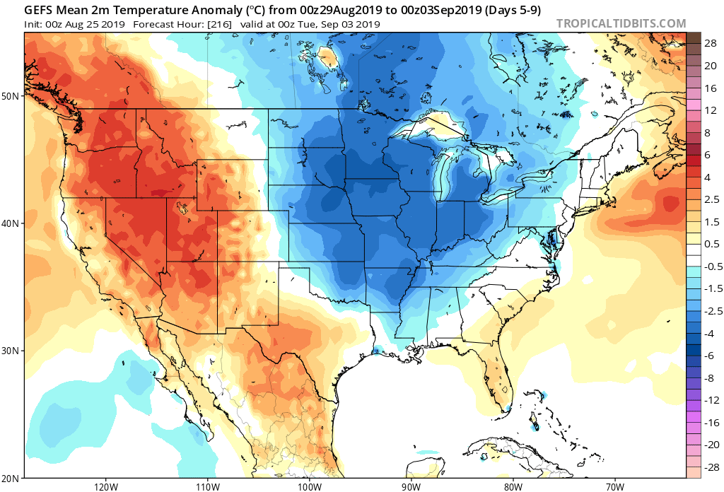
The short-term period will be dominated by a cooler than normal theme as we put the final touches on August and open September.

This will only serve to push those already below normal for the month even cooler than average and turn a lot of the area bordering these cool anomalies “over the top” from seasonal to slightly cooler than normal by month’s end. Meanwhile, warmth will continue to dominate along the coasts

Here’s a look at month-to-date temperature anomalies, compared to our initial August forecast (issued July 21st).

The negative EPO suggests any sort of warmth will be hard to come by and transitional through the 1st 1/3 of the month.

After a wet time of things as of late, we’ll dry things out the middle part of the week. A couple of moisture-starved and rather weak systems may lead to scattered showers Friday and again at times over the holiday weekend, but significant rain isn’t anticipated. We would agree with the drier than average theme displayed from the most recent CFSv2 Weekly product to open September:

The one potential “fly in the ointment” to the dry open to September would be whatever comes from current Tropical Storm Dorian (moving through the Windward Islands as of this update). There’s relatively good model agreement that Dorian will move northwest and eventually be in a position to impact the eastern Florida coastline by the Labor Day weekend as a Tropical Storm.

It’s far too early to speculate from this point, but the pattern may promote Dorian to then track into the Gulf of Mexico. While unlikely Dorian’s remnant moisture ever impacts our immediate region, this will be something that we’ll keep an eye on over the next week to 10 days.

Permanent link to this article: https://indywx.com/2019/08/27/pattern-progression-into-early-september/

Evening Video Update: Locally Heavy Rain Moves In Overnight For Some; Cool Pattern Sets Up Shop…

You must be logged in to view this content. Click Here to become a member of IndyWX.com for full access.  Already a member of IndyWx.com All-Access?  Log-in here.

Permanent link to this article: https://indywx.com/2019/08/26/evening-video-update-locally-heavy-rain-moves-in-overnight-for-some-cool-pattern-sets-up-shop/

VIDEO: Wet Open To The Work Week; Early September Thoughts…

You must be logged in to view this content. Click Here to become a member of IndyWX.com for full access.  Already a member of IndyWx.com All-Access?  Log-in here.

Permanent link to this article: https://indywx.com/2019/08/26/video-wet-open-to-the-work-week-early-september-thoughts/

Sunday Morning Rambles…

I. The dry air we’ve enjoyed the past couple of days will be replaced with an increasingly moist air mass to open the work week.

II. With that will come an increase in cloud cover later today and the possibility of a couple of showers. Better coverage of showers and embedded thunder will return Monday into Tuesday.

Rainfall amounts of 0.25” to 0.75” can be expected during this time period with some neighborhoods accumulating close to an inch.

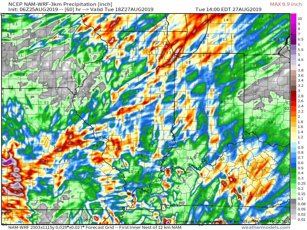
III. A cold front will sweep across the Ohio Valley for midweek leading to a return of dry and unseasonably cool conditions. This will be followed by a second frontal passage Labor Day weekend that will serve to reinforce the cooler than normal air.

Will have a more detailed post, including longer range thoughts later this evening, friends.

Permanent link to this article: https://indywx.com/2019/08/25/sunday-morning-rambles-5/

IndyWx.com