
You must be logged in to view this content. Click Here to become a member of IndyWX.com for full access. Already a member of IndyWx.com All-Access? Log-in here.
April 2019 archive
Permanent link to this article: https://indywx.com/2019/04/11/wet-and-active-pattern-on-deck/
Apr 10
Strong Storms Thursday Night; Early Summer Ideas…
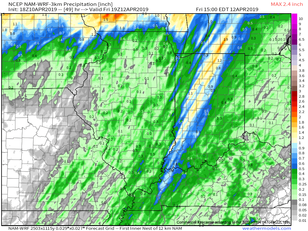
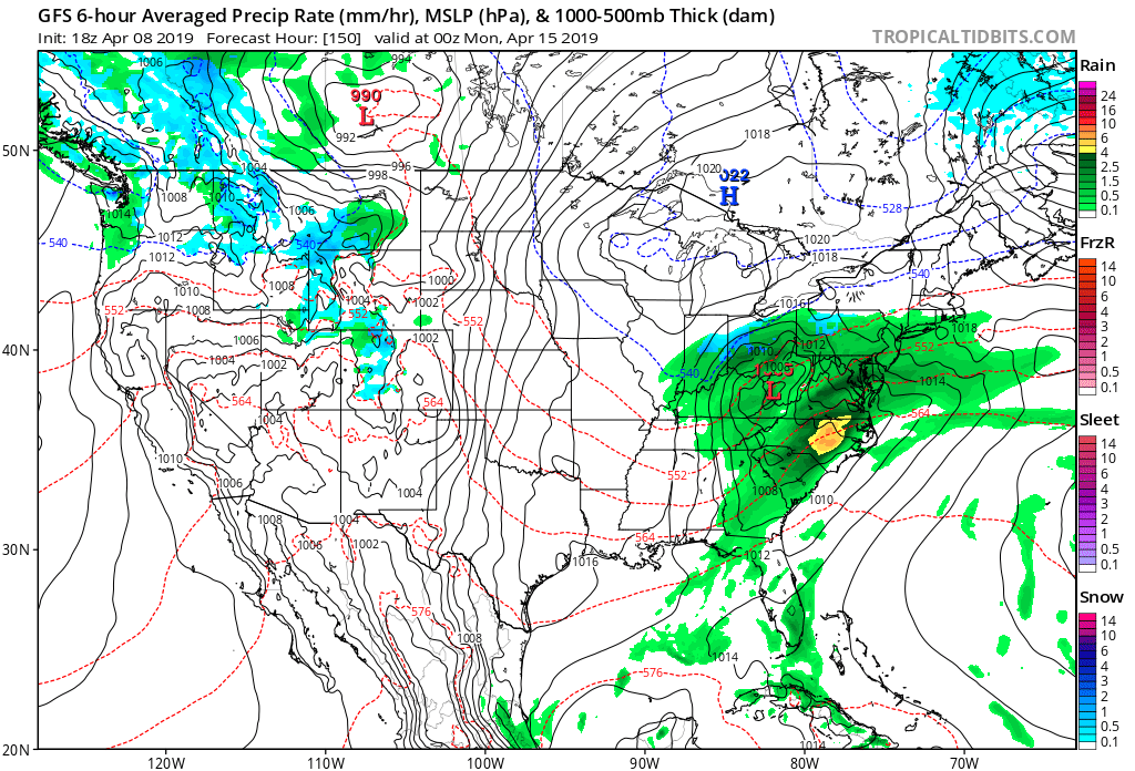
The daytime Thursday will be dominated by a summer-like feel as highs approach the 80 degree mark, along with an increasingly gusty SW wind ahead of an approaching cold front. We’ll stay dry through the day and it’s not until we get to the overnight hours when storm chances will begin to increase.
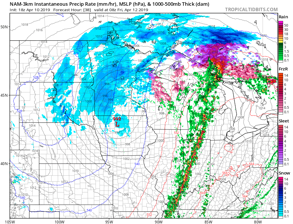
More specifically, we think the hours between 12a and 5a will offer up the best chance of a slow moving line of storms to track across central Indiana. A couple of these storms could produce damaging winds. Locally heavy rainfall can also be expected with widespread amounts of 0.50″ to 1″ with a few 1″+ totals likely by the time we get to sunrise Friday. The rain will be well to our east by lunchtime Friday and a dry close to the day is on tap.
On the heels of this storm will come another wet weather maker Saturday night and Sunday and tomorrow morning’s video update will have more details around timing and rainfall amounts with that system.
Early Summer Ideas
I. Weak El Nino anticipated to persist through the Summer of 2019.
II. Warm SSTs in the Gulf of Mexico and off the Southeast Coast.
We’ll have our complete official Summer Outlook posted during the first week of May, but wanted to share our early thoughts. Overall, a warmer than average summer is expected with average to slightly above normal rainfall, locally.
The warmer than average sea surface temperatures (SSTs) raise concern for the potential of well above average precipitation across the Southeast and MidAtlantic regions. Additionally, those warm water conditions also mean we’ll need to keep close eyes on the potential of tropical activity early on in the season in the Gulf or off the SE coastline.
Much more next month, including graphics!
Talk with you bright and early in the AM!
Permanent link to this article: https://indywx.com/2019/04/10/strong-storms-thursday-night-early-summer-ideas/
Apr 10
VIDEO: Severe Potential Thursday Night; Wet Close To The Weekend…
You must be logged in to view this content. Click Here to become a member of IndyWX.com for full access. Already a member of IndyWx.com All-Access? Log-in here.
Permanent link to this article: https://indywx.com/2019/04/10/video-severe-potential-thursday-night-wet-close-to-the-weekend/
Apr 09
Continuing To Monitor Thursday’s Storm Threat; 2nd Storm Delivers A Wet Close To The Weekend…
You must be logged in to view this content. Click Here to become a member of IndyWX.com for full access. Already a member of IndyWx.com All-Access? Log-in here.
Permanent link to this article: https://indywx.com/2019/04/09/continuing-to-monitor-thursdays-storm-threat-2nd-storm-delivers-a-wet-close-to-the-weekend/
Apr 08
Monitoring The Threat Of Strong-Severe Storms Thursday Evening…
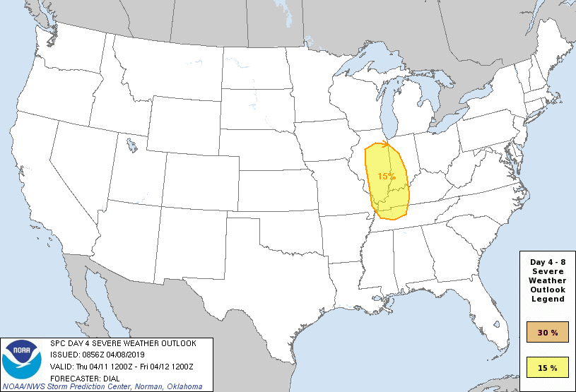
We continue to monitor the potential of strong to severe thunderstorms Thursday evening across the region. Already, the Storm Prediction Center highlights the possibility in their Day 4 Outlook below.
The setup will feature unseasonably warm and moist air being drawn northeastward ahead of a strong spring storm system to our northwest Thursday. This is the same storm system that will deliver a late season blizzard to the north-central Plains and upper Midwest.
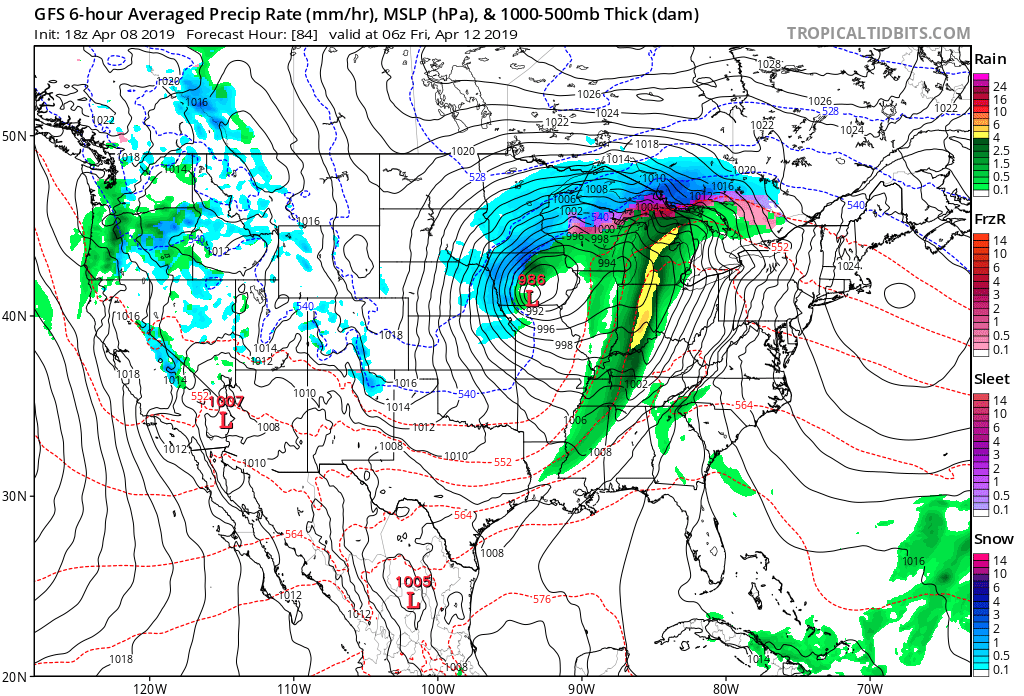
A trailing cold front will push east into the unseasonably warm air mass (expecting highs in the mid-upper 70s Thursday with a strong and gusty SW wind) and we expect a line of thunderstorms to organize to our west Thursday afternoon. While timing will have to be fine tuned over the next couple of days, current thinking places this line of storms into central Indiana by Thursday evening. The primary threat continues to be damaging straight line winds.
We’ll turn drier and cooler to close the week and another storm system will approach by Saturday night. This particular storm system looks to deliver a widespread cold, soaking rain especially across the eastern half of the OHV region- from central IN and points east. More on this storm after we get rid of Thursday’s storms.
Permanent link to this article: https://indywx.com/2019/04/08/monitoring-the-threat-of-strong-severe-storms-thursday-evening/
Apr 08
VIDEO: Work Week Outlook; Early May Ideas…
You must be logged in to view this content. Click Here to become a member of IndyWX.com for full access. Already a member of IndyWx.com All-Access? Log-in here.
Permanent link to this article: https://indywx.com/2019/04/08/video-work-week-outlook-early-may-ideas/
Apr 07
Scattered Storms Develop This Evening And Tonight…
You must be logged in to view this content. Click Here to become a member of IndyWX.com for full access. Already a member of IndyWx.com All-Access? Log-in here.
Permanent link to this article: https://indywx.com/2019/04/07/scattered-storms-develop-this-evening-and-tonight/
Apr 06
#AGwx & Weekly Severe Weather Outlook…
With the first Saturday of April upon us, it’s time for our 1st installment of a weekly update dedicated just to our AG interests. These are updates private clients have been receiving for years and we’re excited to be able to include these Saturday updates within the All-Access platform now. These updates will be posted on Saturdays through the end of September.
Forecast Period: 04.07.19-04.14.19
7-Day Precipitation: Average amounts of precipitation expected.
7-Day Temperatures: Above normal temperatures expected.

Severe Weather:
We’re monitoring the possibility of severe weather Sunday (4.7.19) across the southern half of the state. Additionally, there’s the threat of strong to severe storms Thursday afternoon and evening (4.11.19).

Summary:
The upcoming forecast period will be dominated by (2) systems. A warm front will lift north across central Indiana Sunday morning and feature a couple of rounds of thunderstorms across the southern half of the state. While a significant and widespread severe weather outbreak isn’t expected, a couple of strong to severe storms are possible Sunday morning and again Sunday afternoon. Greatest concerns include a threat of large hail and damaging straight line winds.
A second storm system will impact the area Thursday afternoon and evening. Model guidance has trended significantly further north with the track of the surface low and accordingly, trends would favor a warmer solution here, along with the likelihood of more in the way of Gulf of Mexico moisture being pulled as far north as the OHV region. We’ll need to monitor for the threat of additional strong to severe storms during the Thursday afternoon/ evening time frame.
Behind the cold front, drier and cooler air will work into the area as we get set to close the work week. The upcoming week will be dominated by highs in the upper 60s to lower 70s and lows in the 50s. Temperatures will trend cooler late week and next weekend (more like highs in the 50s and lows in the 30s).
Permanent link to this article: https://indywx.com/2019/04/06/agwx-weekly-severe-weather-outlook/
Apr 06
VIDEO: Scattered Storms Impact The Area Sunday; Timing Out Next Week’s Systems…
You must be logged in to view this content. Click Here to become a member of IndyWX.com for full access. Already a member of IndyWx.com All-Access? Log-in here.
Permanent link to this article: https://indywx.com/2019/04/06/video-scattered-storms-impact-the-area-sunday-timing-out-next-weeks-systems/
Apr 05
Enjoy The Spring Warmth While We’ve Got It: Cold, Stormy Pattern On Deck…
You must be logged in to view this content. Click Here to become a member of IndyWX.com for full access. Already a member of IndyWx.com All-Access? Log-in here.
Permanent link to this article: https://indywx.com/2019/04/05/enjoy-the-spring-warmth-while-weve-got-it-cold-stormy-pattern-on-deck/