
You must be logged in to view this content. Click Here to become a member of IndyWX.com for full access. Already a member of IndyWx.com All-Access? Log-in here.
April 2019 archive
Permanent link to this article: https://indywx.com/2019/04/17/video-timing-out-the-heavy-rain-event-to-close-the-work-week/
Apr 17
Heavy Rain On Deck; Big Model Differences Early Next Week…
As we rumble into the 2nd half of April, it’s apparent the month will take on an increasingly wet look. (So far, the 2019 version is running slightly drier than normal).
Today will take on a warm and increasingly humid feel as the afternoon and evening wears on. A couple of light showers are possible this afternoon and evening, but most of the day will remain free of any rain.
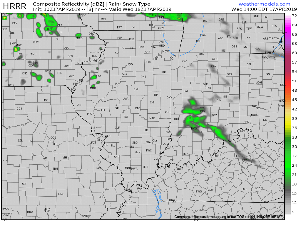
A cold front will draw closer to the region on Thursday and this will lead to much better chances of more organized shower and thunderstorm activity.
The first round of storms is expected to arrive around the morning rush hour Thursday and a couple of stronger cells are possible, including vivid lightning and heavy downpours.
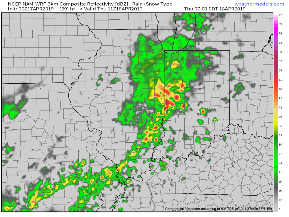
Overall, Thursday is looking unsettled, with periods of showers and embedded thunder continuing through the day. A couple of stronger storms are possible, but the morning convection will greatly limit the potential of a more widespread and significant severe weather event in the afternoon.

By the time all is said and done early Friday morning, 2″ to 2.5″ of rain can be expected across central and southern Indiana.

Cooler air will flow in here for Good Friday and Saturday, but improvements can be expected for Easter Sunday, including much warmer temperatures (highs will rebound into the mid 70s Easter afternoon)!
Attention then shifts to rather significant model differences through the early portions of the work week. The primary reason? Differences with the specific placement of a “backdoor” cold front that will lie across the Ohio Valley through the first half of the work week. Shower and thunderstorm chances will return Monday in association with this frontal boundary, but temperatures are much more of a headache. There’s as much as 20 degree difference between the European and GFS guidance and we’ll have to keep a close eye on the precise position of the backdoor cold front as we move forward- especially with respect to the potential impacts of Monday and Tuesday’s temperatures. Stay tuned.
Permanent link to this article: https://indywx.com/2019/04/17/heavy-rain-on-deck-big-model-differences-early-next-week/
Apr 16
Thursday Storm Threat Discussion; Easter Weekend Forecast And Looking Ahead To Late April…
You must be logged in to view this content. Click Here to become a member of IndyWX.com for full access. Already a member of IndyWx.com All-Access? Log-in here.
Permanent link to this article: https://indywx.com/2019/04/16/thursday-storm-threat-discussion-easter-weekend-forecast-and-looking-ahead-to-late-april/
Apr 15
Evening Video Update On Thursday’s Storm Threat; Heavy Rain Potential To Open Easter Weekend…
You must be logged in to view this content. Click Here to become a member of IndyWX.com for full access. Already a member of IndyWx.com All-Access? Log-in here.
Permanent link to this article: https://indywx.com/2019/04/15/evening-video-update-on-thursdays-storm-threat-heavy-rain-potential-to-open-easter-weekend/
Apr 15
VIDEO: Improving Early Week Weather; Active Pattern Leading Up To Easter…
You must be logged in to view this content. Click Here to become a member of IndyWX.com for full access. Already a member of IndyWx.com All-Access? Log-in here.
Permanent link to this article: https://indywx.com/2019/04/15/video-improving-early-week-weather-active-pattern-leading-up-to-easter/
Apr 14
NowCast Update On This Afternoon’s Storm Threat Across The Ohio Valley…
You must be logged in to view this content. Click Here to become a member of IndyWX.com for full access. Already a member of IndyWx.com All-Access? Log-in here.
Permanent link to this article: https://indywx.com/2019/04/14/nowcast-update-on-this-afternoons-storm-threat-across-the-ohio-valley/
Apr 14
VIDEO: We Turn Much Colder This Evening; Timing Out Storms Into Easter Weekend And We Also Review The Late April Pattern…
You must be logged in to view this content. Click Here to become a member of IndyWX.com for full access. Already a member of IndyWx.com All-Access? Log-in here.
Permanent link to this article: https://indywx.com/2019/04/14/video-we-turn-much-colder-this-evening-timing-out-storms-into-easter-weekend-and-we-also-review-the-late-april-pattern/
Apr 13
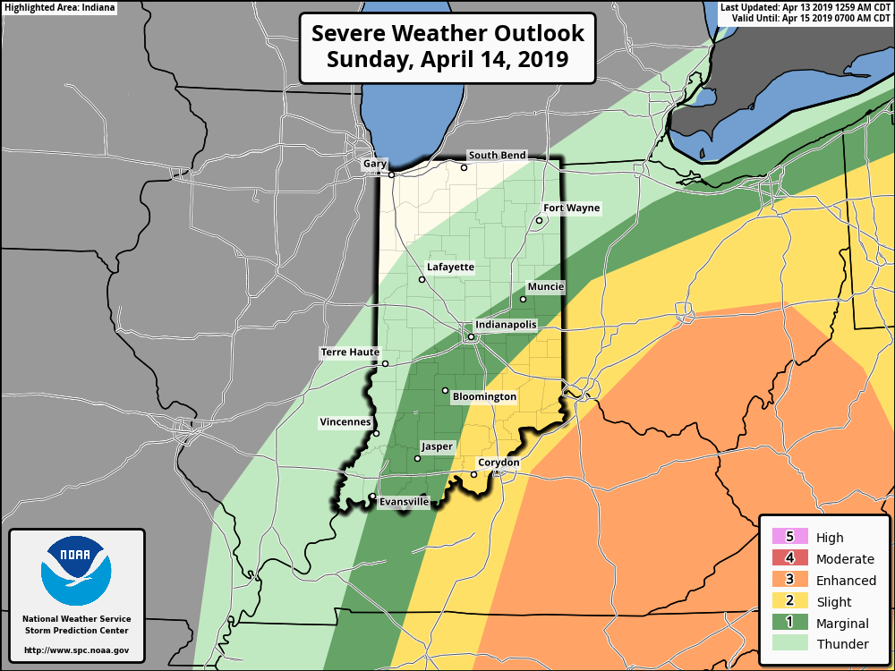
#AGwx & Weekly Severe Weather Outlook
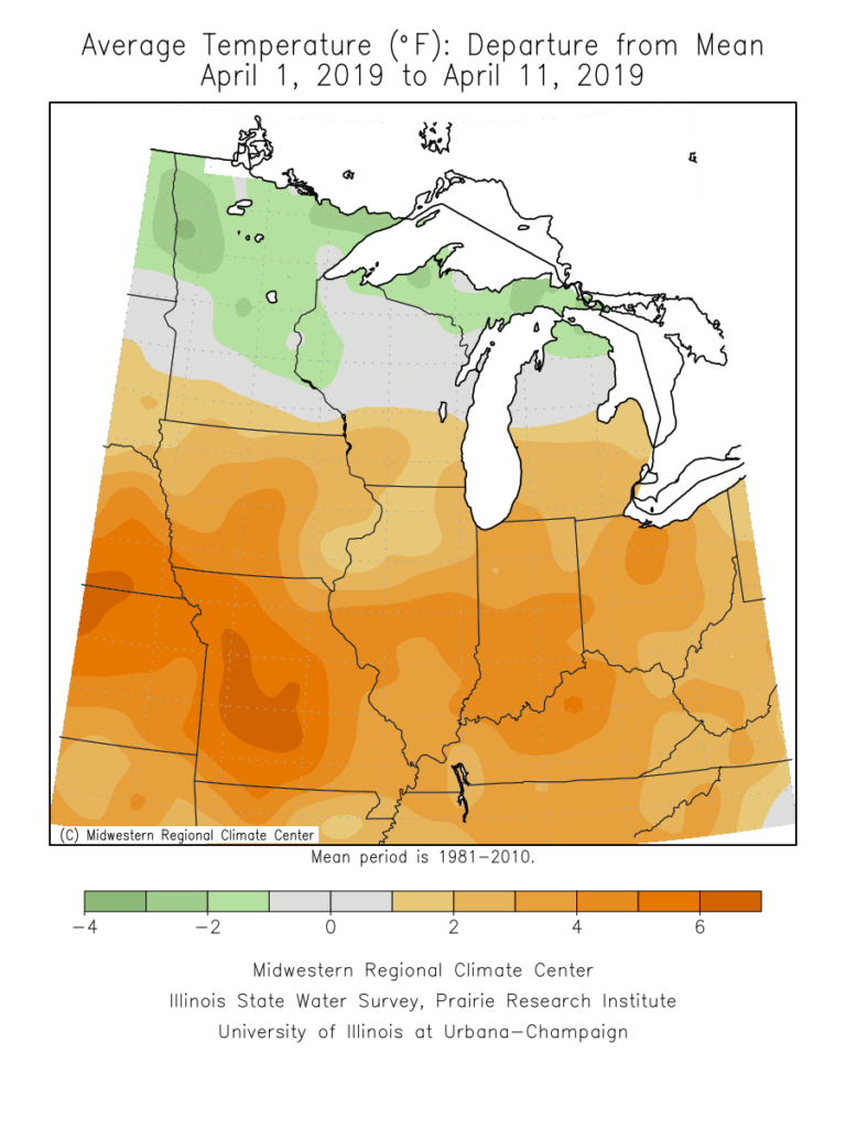
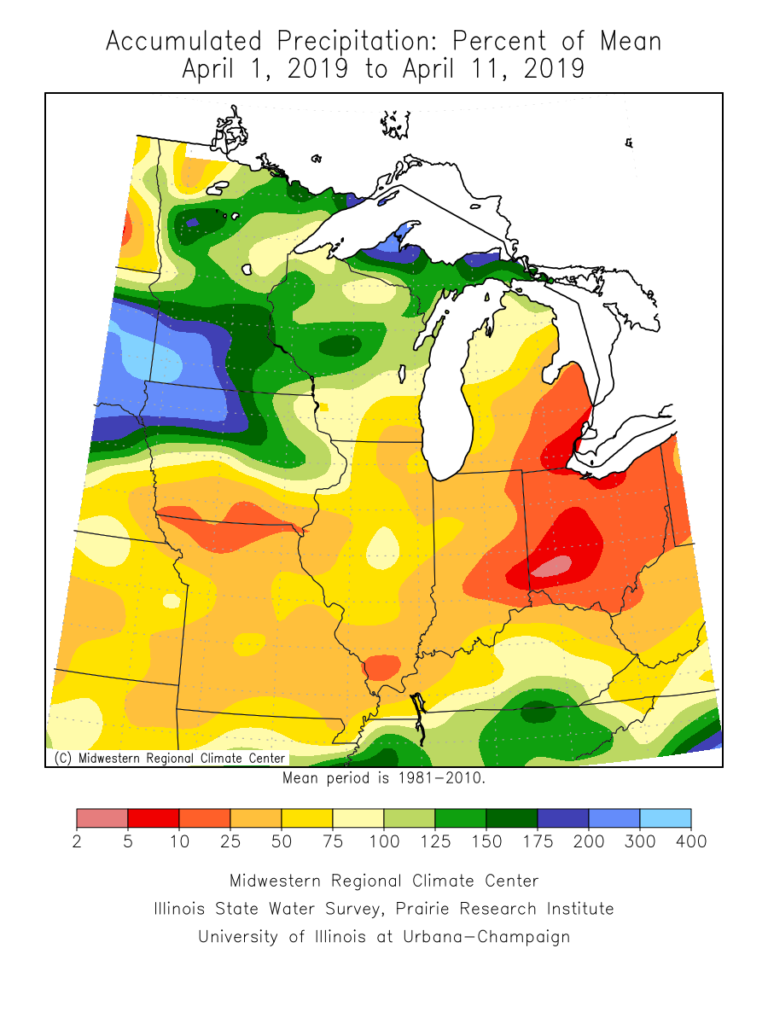
Before we look ahead to the upcoming period, reviewing April so far shows a warm and dry start to the month. April 2019 is running nearly 5 F above average and 0.76″ below normal in the rainfall department.
Forecast Period: 04.14.19 through 04.21.19
7-Day Precipitation: Above normal amounts of precipitation expected during the period.

7-Day Temperatures: Above normal temperatures expected during the period.
Severe Weather:
A risk of strong to potentially severe storms looms across southeast portions of the state Sunday (4.14.19). While widespread severe weather isn’t anticipated, there’s the potential of scattered strong storms Thursday, 04.18.19.
Summary:
A strong spring storm system will deliver heavy rain and thunderstorms late tonight into Sunday. Due to the track of the surface low, a tight temperature gradient can be expected across the state Sunday. Low-mid 60s are on deck across SE IN with upper 30s across western and northern portions of the state. In the warmer sector, a severe threat looms Sunday morning into the afternoon hours. Large hail is the primary concern with storms that may form. Elsewhere, a rather widespread 1″ to 2″ of rain is a good bet with the passage of this system.
While we’ll remain cool to open the work week, a warm front will lift north Tuesday helping to usher in much warmer conditions for the mid-week stretch (70s return). The next system will approach Wednesday into Thursday with scattered showers and thunderstorms (some of which may be strong Thursday). That particular system will track overhead Friday into next weekend with cooler air returning during the period (highs in the 50s and lows in the upper 30s to lower 40s for next weekend).
Permanent link to this article: https://indywx.com/2019/04/13/agwx-weekly-severe-weather-outlook-2/
Apr 12
Improving Weather Today; Another Round Of Heavy Rain & Storms On Deck…
You must be logged in to view this content. Click Here to become a member of IndyWX.com for full access. Already a member of IndyWx.com All-Access? Log-in here.
Permanent link to this article: https://indywx.com/2019/04/12/improving-weather-today-another-round-of-heavy-rain-storms-on-deck/
Apr 11
Thursday Night Storm Update; Heavy Rain Maker Sunday…
We’re still quiet across central Indiana just before 10:30p, but showers and thunderstorms will overspread the area during the overnight. Best chances of the potential of damaging straight line winds will be along the western IN state line, but a couple of embedded strong storms and locally heavy rain will encompass all of the central portion of the state after midnight. Greatest coverage of showers and thunderstorms will come during the window of 1a and 6a.
Total rainfall amounts will average between 0.50″ and 1″ with a couple of locally heavier totals.

We still expect the rain to exit stage right well before the lunchtime hour Friday with dry conditions prevailing as we get set to put a wrap on the work week.
After the warmest day so far this year, temperatures will be much cooler Friday behind the cold front (to the tune of 20-30 degrees)!

Dry conditions will continue through the daytime Saturday, but a big ole wet storm system will be taking shape to our southwest by that time and it’ll have its’ eyes set on our area for an overnight arrival Sunday. The second half of the weekend will be dominated by gusty winds and wet conditions.
An all day soaker is expected with heavy rain at times. An additional 1″ to 2″ is a good bet Sunday.
After a dry open to April, we’re set to make up for the quiet times (and some) over the course of the next few days, and the hits don’t look to stop there as we head into next week.
Permanent link to this article: https://indywx.com/2019/04/11/thursday-night-storm-update-heavy-rain-maker-sunday/