Updated 02.28.23 @ 7:18a
You must be logged in to view this content. Click Here to become a member of IndyWX.com for full access. Already a member of IndyWx.com All-Access? Log-in here.

Feb 28
Updated 02.28.23 @ 7:18a
You must be logged in to view this content. Click Here to become a member of IndyWX.com for full access. Already a member of IndyWx.com All-Access? Log-in here.
Permanent link to this article: https://indywx.com/2023/02/28/video-heavy-wind-whipped-rain-arrives-to-close-the-work-week/
Feb 27
Updated 02.27.23 @ 6:15p
Temperatures are running around 7° above normal at IND February to-date, and the first few days of March will also get off to a well above normal start. Winter, as a whole, aside from the bitter pre-Christmas blast, has been absolutely forgettable to most winter weather enthusiasts. I suppose it only makes sense that just as most are ready for “stick and hold” spring weather to show itself, we are seeing the best alignment and most bullish signal for persistent anomalous cold from a variety of pattern drivers all winter long. 😉
Long time IndyWx viewers know that this is the time of year we lean heaviest of NAO impacts, particularly if in a negative state. Latest long range data places the NAO in a negative state for the better part of the upcoming (6) weeks:

This strongly argues for more of a persistent eastern trough, including below normal temperatures and an active storm track, thanks to the busy Pacific pattern.
Secondly, and we really should have started with this one, the Madden-Julian Oscillation is finally set to rotate into the traditionally cold phases (8 and then 1) as we flip the page to the 2nd week of March and beyond. This should eventually translate into a widespread cold pattern, including the East, with an active coast-to-coast storm track continuing. Also note the high latitude blocking emerging as we transition into Phase 1.


Throw in a negative WPO, and this further backs up the widespread cold, active pattern. Similar to the NAO chart to open this piece, the majority of the (6) week period is spent in a negative state. Pattern alignment…

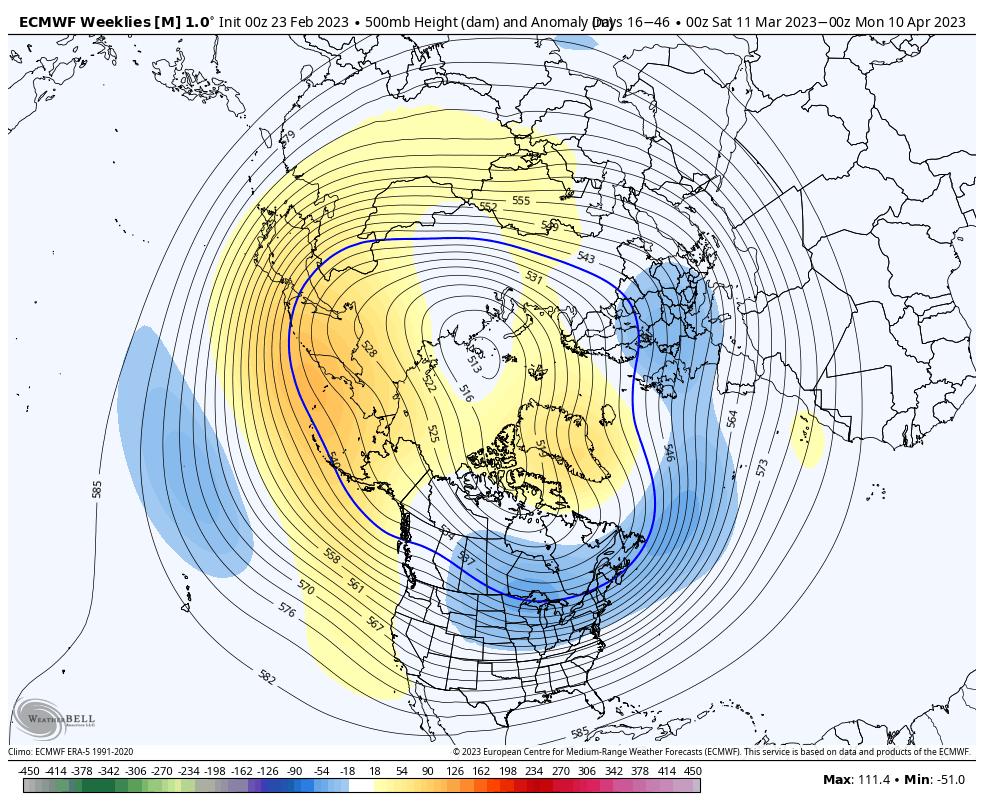
Add in all of this and there’s no wonder the most updated (as of this afternoon) European Weeklies are banging the drum, quite loudly I might add, for a prolonged period of colder than normal weather from mid-March through mid-April. Don’t put away that cold weather gear- or snow shovels just yet…

Permanent link to this article: https://indywx.com/2023/02/27/spring-tease-just-that-long-long-road-ahead/
Feb 27
Updated 02.27.23 @ 7:40a
You must be logged in to view this content. Click Here to become a member of IndyWX.com for full access. Already a member of IndyWx.com All-Access? Log-in here.
Permanent link to this article: https://indywx.com/2023/02/27/video-window-for-severe-weather-late-morning-into-early-afternoon-late-week-storm-on-deck/
Feb 26
Updated 02.26.23 @ 4:30p
You must be logged in to view this content. Click Here to become a member of IndyWX.com for full access. Already a member of IndyWx.com All-Access? Log-in here.
Permanent link to this article: https://indywx.com/2023/02/26/video-latest-details-on-mondays-severe-threat-and-our-late-week-storm/
Feb 25
Updated 02.25.23 @ 8:28a

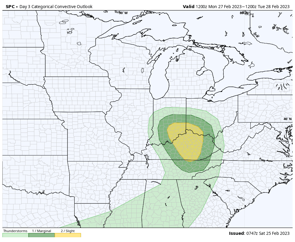
3. Attention will then shift to mid week as multiple pieces of energy try and bundle together to generate another size-able storm. Confidence on any one particular solution is low at this distance, but with colder air pressing east, this system will likely have a more widespread wintry component on the north and west flank. No reason to speculate further from this distance, but know we’ll continue closely monitoring trends.
4. Finally, it continues to look like any and all who believed winter was over will be sorely mistaken. Confidence continues to grow in a cold to much colder than normal 2nd half of March, which likely continues to push into at least early April. Note the updated European Weeklies for the time period March 10 to April 10. That’s a classic look for significant late season cold. We’re also likely far from finished with wintry precipitation…


Permanent link to this article: https://indywx.com/2023/02/25/saturday-morning-rambles-eyes-on-severe-threat-to-open-the-week-and-winters-return/
Feb 24
Updated 02.24.23 @ 6a
You must be logged in to view this content. Click Here to become a member of IndyWX.com for full access. Already a member of IndyWx.com All-Access? Log-in here.
Permanent link to this article: https://indywx.com/2023/02/24/lr-update-prolonged-period-of-unseasonably-cold-active-weather-on-deck/
Feb 23
Updated 02.23.23 @ 9a
You must be logged in to view this content. Click Here to become a member of IndyWX.com for full access. Already a member of IndyWx.com All-Access? Log-in here.
Permanent link to this article: https://indywx.com/2023/02/23/video-busy-pattern-remains-in-place-as-we-head-into-next-week/
Feb 22
Updated 02.22.23 @ 8:29a
You must be logged in to view this content. Click Here to become a member of IndyWX.com for full access. Already a member of IndyWx.com All-Access? Log-in here.
Permanent link to this article: https://indywx.com/2023/02/22/video-unsettled-today-and-tracking-a-new-strong-storm-early-next-week/
Feb 21
Updated 02.21.23 @ 7:45a
You must be logged in to view this content. Click Here to become a member of IndyWX.com for full access. Already a member of IndyWx.com All-Access? Log-in here.
Permanent link to this article: https://indywx.com/2023/02/21/video-wholesale-pattern-change-just-as-most-are-wanting-spring-tracking-2-storm-systems-over-the-next-7-days/
Feb 20
Updated 02.20.23 @ 8:37a
You must be logged in to view this content. Click Here to become a member of IndyWX.com for full access. Already a member of IndyWx.com All-Access? Log-in here.
Permanent link to this article: https://indywx.com/2023/02/20/video-timing-out-when-rain-returns-updated-look-at-the-longer-range-pattern-drivers/