You must be logged in to view this content. Click Here to become a member of IndyWX.com for full access. Already a member of IndyWx.com All-Access? Log-in here.
February 2019 archive
Permanent link to this article: https://indywx.com/2019/02/06/wednesday-morning-video-update-heavy-rain-severe-threat-give-way-to-much-colder-air-and-a-potential-late-weekend-winter-event/
Feb 05
Whole Lot Of Weather Going On…
There’s sure no shortage of active weather, and unfortunately (or fortunately- depending on your perspective), there’s no letup in sight. As we look ahead, we see a fascinating battle of heavyweights set to duke it out for control of our mid and late February pattern. Before we get into some of the longer range model updates, let’s focus on the short and medium term challenges.
Heavy Rain
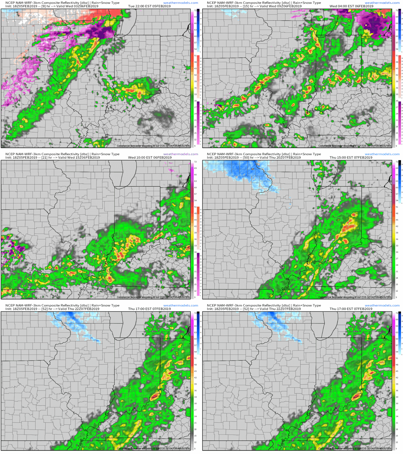
We continue to target (3) distinct windows where rainfall will be heaviest:
I. Late tonight-Wednesday morning
II. Wednesday night-Thursday morning
III. Thursday evening
In general, widespread 2″ to 2.5″ totals are expected in area rain gauges with heavier amounts across south-central Indiana (where flood risks are highest).
The other item to note? The potential of strong and gusty thunderstorms Thursday afternoon into the early evening. These would be located directly ahead of the cold front. While we’re not anticipating a widespread major event, temperatures and dew points will approach 60 deg. and the atmosphere will be favorable to support a few strong gusts that may mix down to the surface.

Sharply Colder
The cold front that will deliver the heavy rainfall for our midweek will sweep through central Indiana around 4p-5p. Behind the boundary, sharply colder air will blow in on strong and gusty northwest winds Thursday night. Daytime highs (actual highs will occur at midnight Friday) will only top out in the lower 20s with wind chill values in the 0s most of the day.

Winter Threat Late Weekend-Early Next Week?
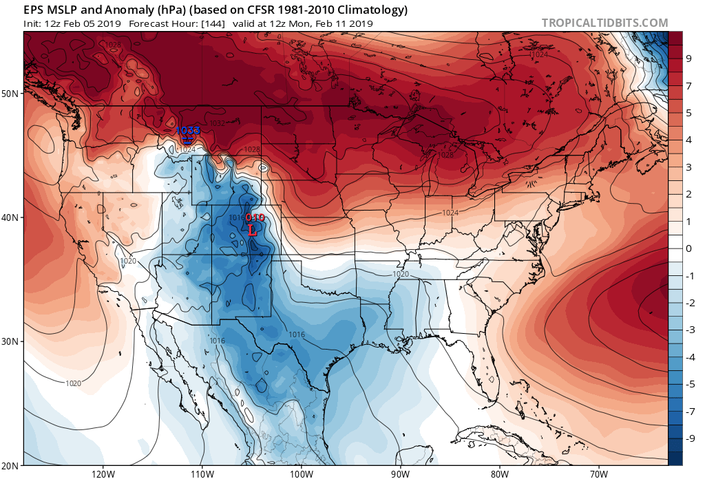


The fresh batch of cold air in here to wrap up the work week will lay the ground work for potential wintry mischief late weekend into early next week. While the cold still isn’t set to truly establish itself (still think we’re a week-10 days away from that), just enough cold may be around to present the opportunity for an accumulating central and northern Ohio Valley winter threat in the Sunday-Tuesday period. Stay tuned as we fine tune things.
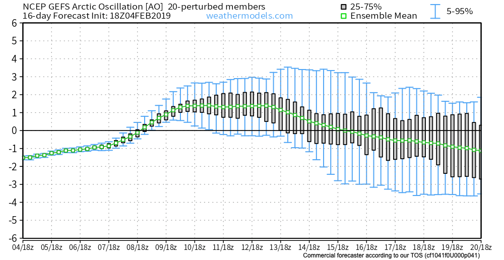
The hesitation that we still have from beginning to “ring the bells” a little louder in the aforementioned period is the position of the high in front of the storm and forecast strongly positive AO. Both of these argue against the idea of this being a widespread wintry event for the southern, and potentially as far north as central Ohio Valley. The early idea here as of now is that we’ll be looking at a wintry mix event to rain for central and southern areas with more of an opportunity for substantial snow across the northern portions of the Ohio Valley. Again, stay tuned as we continue to fine tune things.
Longer term, today’s MJO update continues to take things into Phase 8 and you don’t need us to cover the end result again (think cold) at this point. Should we get the other teleconnections to line-up (AO, PNA, NAO) then a 2-3 week period of significant winter weather would ensue during the 2/20-3/10 timeframe…
Permanent link to this article: https://indywx.com/2019/02/05/whole-lot-of-weather-going-on/
Permanent link to this article: https://indywx.com/2019/02/05/tuesday-morning-video-heavy-rain-and-looking-ahead-to-a-wintry-threat-late-weekend-for-some/
Feb 04
+ AO Supports Current Warmth; Active Pattern Shows No Signs Of Letting Up Into Early March…
After the record-setting cold that gripped the Mid West and Ohio Valley for a few days, the recent “spring fling” has been welcomed with open arms by many! There are multiple reasons behind the warmth, especially with such a strong Arctic Oscillation (AO) in place.
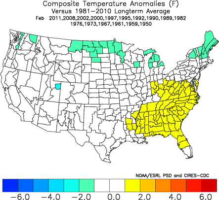
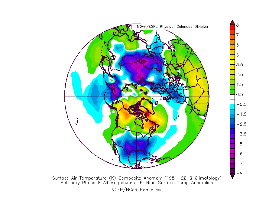
We note the strongly positive AO (image 1) and the respective temperature anomalies that should result (image 2).

To no surprise, model data is bullish on the southeastern ridge holding firm this week.
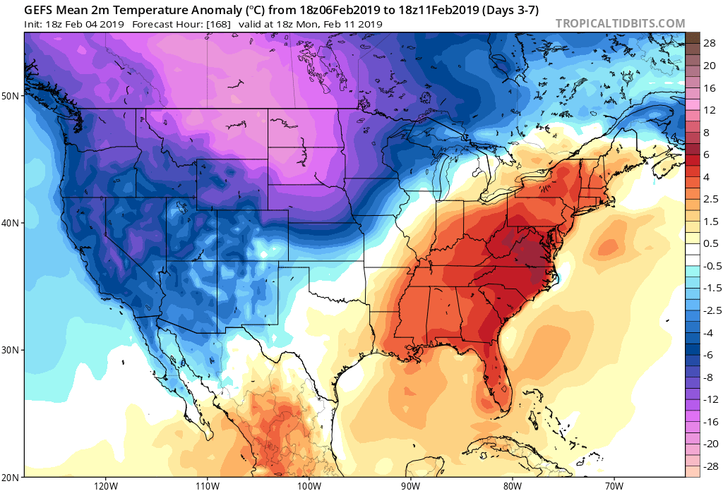
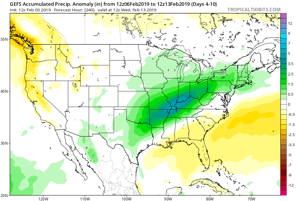
The resistance put forth by the southeast ridge, combined with the renewed arctic air building across the Northern Rockies/ Northern Plains will continue to yield a very active storm track through the Ohio Valley. We expect precipitation to remain well above normal through month’s end, continuing into early March.
As we look ahead, we note modeling is trending the AO neutral and negative for mid and late month.

As this is taking place, the MJO is forecast to swing into Phase 8.

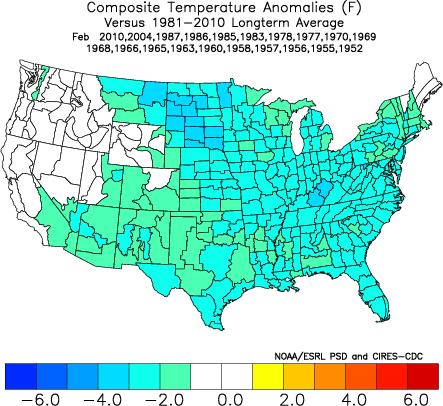
Phase 8 in mid to late February is a very cold phase.
Should the AO continue to trend negative, that will only raise confidence that cold will return.
Warmth (relative to normal) will continue to rule the day through midweek before we go into more of a transitional period this weekend into next week. Though certainly colder than this week, I’m not quite ready to buy into the idea that the southeast ridge will go quietly into the night. A couple of winter threats loom late weekend into next week, but confidence is low in the specifics. It’s when we get to the last (2) weeks of the month that we think cold will regain control, along with more widespread wintry threats of significance…
Permanent link to this article: https://indywx.com/2019/02/04/ao-supports-current-warmth-active-pattern-shows-no-signs-of-letting-up-into-early-march/
Feb 04
Monday Morning Video: Heavy Rain And Freezing Rain Potential Grabs The Headlines…
You must be logged in to view this content. Click Here to become a member of IndyWX.com for full access. Already a member of IndyWx.com All-Access? Log-in here.
Permanent link to this article: https://indywx.com/2019/02/04/monday-morning-video-heavy-rain-and-freezing-rain-potential-grabs-the-headlines/
Feb 03
Pre Super Bowl Rambles: Stormy Pattern Shifts To A Return Of Significant Cold?
In the short-term, there’s no getting around the very active pattern in place. As we’ve been discussing, we’ll find ourselves “smack dab” in the middle of a battle ground between a stubborn southeast ridge and building cold to our northwest. The fight in between will yield well above normal precipitation over the next couple of weeks.
Over the upcoming (10) days, expect a roller coaster ride in the temperature department as the battle takes place. While the most anomalous warmth is taking place now (IND is on pace to set a new record high temperature before the end of the day), relative warmth will continue to dominate into midweek before colder air presses and wins out.
After Monday’s light rain, we’re targeting (3) opportunities for significant precipitation across the region:
I. Tuesday night-Wednesday (still may include a risk of freezing rain across north-central communities).
II. Wednesday night-Thursday morning
III. Thursday night-Friday morning (ending as light snow)
When all is said and done, model data is in agreement on significant rainfall totals across central Indiana (2″ to 3″ amounts will be common by Friday).
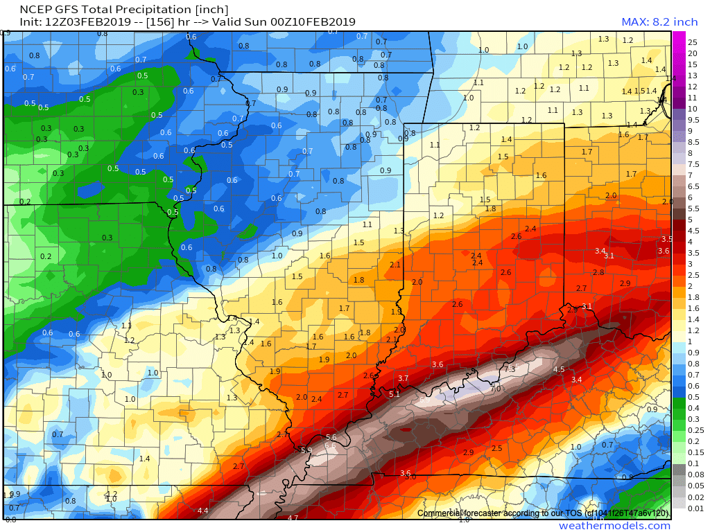
Thereafter, confidence is high on colder air returning as we close the week and head into next weekend.
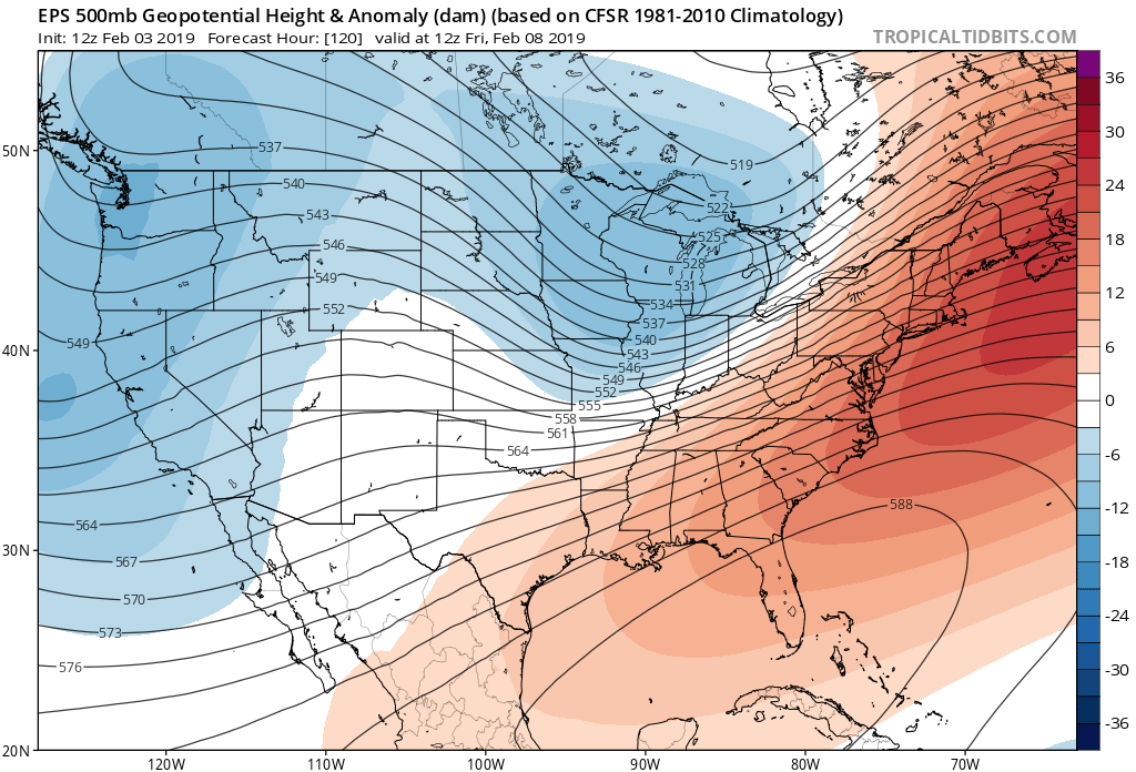

Guidance suggests that we still need to remain abreast of the potential of a more widespread wintry event late next weekend and this is something we’ll continue to keep close tabs on as we progress through the upcoming week. As of now, this doesn’t appear to be a major event, but stay tuned.
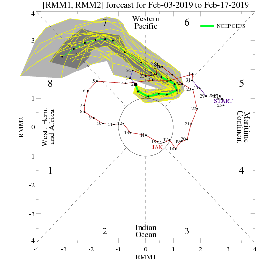
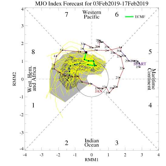
As we look ahead, we’ll have to continue keeping a close eye on the MJO. Today’s update shows the majority of data swinging things into Phase 8 by mid to late month. Should that come to fruition, prospects of another significant cold spell loom large…

Fun times ahead- no matter how you look at it! 🙂
Enjoy the game!
Permanent link to this article: https://indywx.com/2019/02/03/pre-super-bowl-rambles-stormy-pattern-shifts-to-a-return-of-significant-cold/
Feb 03
Sunday Morning Video Update: Walking Through The Active Week Ahead; Looking Towards Mid-Feb…
A new week has dawned and with it will come a very busy weather pattern. Thankfully, today we’ll enjoy a “hint of spring,” including temperatures approaching the 60 deg. mark…
You must be logged in to view this content. Click Here to become a member of IndyWX.com for full access. Already a member of IndyWx.com All-Access? Log-in here.
Permanent link to this article: https://indywx.com/2019/02/03/sunday-morning-video-update-walking-through-the-active-week-ahead-looking-towards-mid-feb/
Feb 02
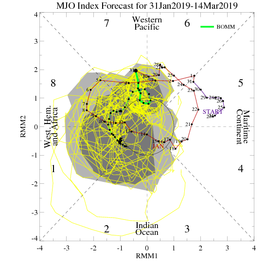
Plot Thickens With The MJO…
There’s a lot of interest (no matter the time of year) in the medium to long range weather pattern. With operational modeling updating up to (4) times per day during this time range, there’s always at least some degree of fluctuation between model runs. At times, that fluctuation is more significant than others. It’s at those times when it’s more important than ever to lean on analogs, teleconnections, and other pattern drivers.
Recall that the MJO has been hyper active for the better part of this season- and has played a significant role in the winter pattern through the 1st half of this season. When the MJO features significant amplitude, it’s imperative that we pay close attention.
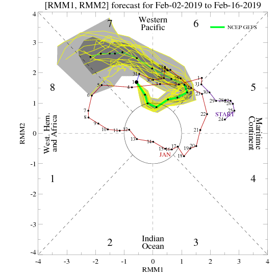

With that said, we note today that the models handle the current MJO pulse much differently between one another over the next couple of weeks.
For example, let’s go with the GEFS (image 1), curling the MJO into Phase(s) 6 and 7. From a temperature perspective, this is how that would be reflected at the surface
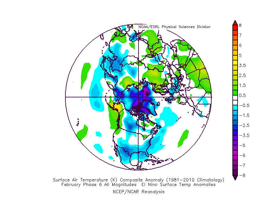

With that said, the European is more bullish heading into Phase 8 by mid-February. If correct, that opens the door for more significant (and widespread) cold.

We’ll continue to keep a very close eye on the MJO over the next week, or so, and hope for better overall agreement between the data. However, given a balance of current teleconnections, SSTs, and MJO, we continue to believe the pattern over the next few weeks will transition from a “battle zone” initially towards one that features cold overwhelming the region by mid-month.
There will likely be rather wild temperature swings through the first 1/3 of the month and that will help power the active pattern. At the end of the day, we expect well above normal precipitation, near-average to slightly colder than normal temperatures, and above average snowfall during the month of February here across central Indiana.
Permanent link to this article: https://indywx.com/2019/02/02/plot-thickens-with-the-mjo/
Feb 02
Timing Out Storms In What Will Be A Very Active Upcoming Couple Weeks…
This morning’s video update takes a closer look at the individual storm systems that have our attention over the upcoming 10-14 days. We continue to expect our neck of the…
You must be logged in to view this content. Click Here to become a member of IndyWX.com for full access. Already a member of IndyWx.com All-Access? Log-in here.
Permanent link to this article: https://indywx.com/2019/02/02/timing-out-storms-in-what-will-be-a-very-active-upcoming-couple-weeks/
Feb 01
6-10 Day Update: Active Times Ahead…
While we’re in the process of pulling out of the bitterly cold air mass, there’s no shortage of action when we look ahead at the upcoming couple of weeks.
Confidence remains high that the upcoming short-term period (Days 2-6) will flip to much warmer than average. A couple days that at least flirt with the 60 degree mark can be expected Sunday and Monday.

While rain will return to the forecast Monday, the milder air sure will be a nice change of pace from the bitterness of the past several days. Enjoy it!
With that said, there are continued indications that the warmth won’t hold.
As we look at the latest medium range ensemble guidance (Days 6-10), the GEFS and EPS are in relatively good agreement.
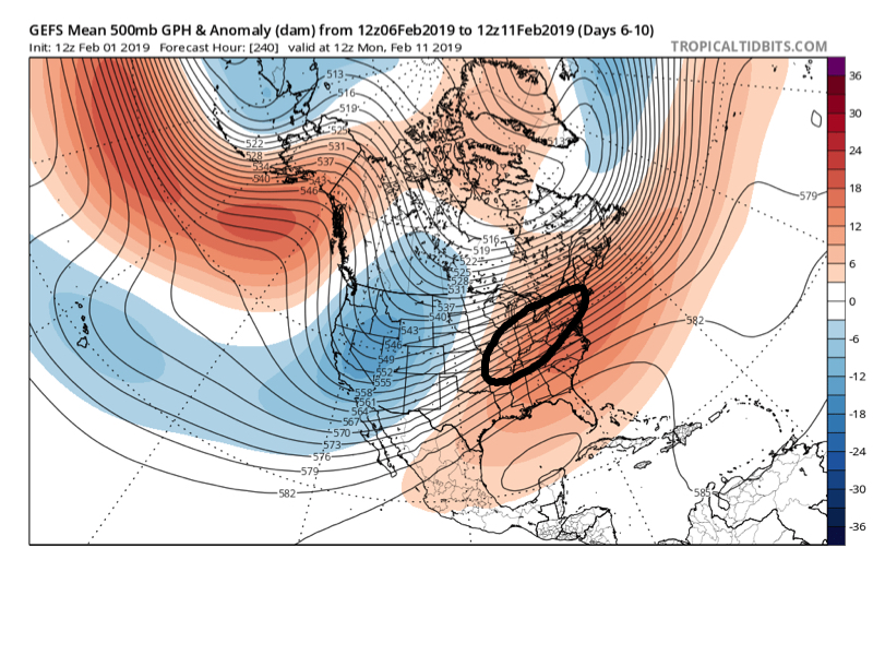

We note this is a pattern conducive for above normal precipitation during the period. With cold air likely to be “pressing” towards the region, it’s a pattern that has to raise an eyebrow for at least the potential of a wintry threat during this time frame. There should be plenty of low level cold air available late next week and next weekend. With the resistance shown from the SE ridge, potential “fun and games” are on the table during this timeframe as waves of energy likely ride along a slow (at times stalled) frontal boundary.
Keep an eye on the 2/7 through 2/10 window for possible wintry impacts, locally…
Permanent link to this article: https://indywx.com/2019/02/01/6-10-day-update-active-times-ahead/

