VIDEO: Typical “Splash And Dash” Summer Variety Of Storms Now; Wet Roller Coaster Ride Next Week…

Updated 08.07.26 @ 7:24a

Seasonably warm and increasingly humid conditions will be in place this weekend with widely scattered showers and thunderstorms. Coverage will be most numerous during the afternoon and into the evening before diminishing. As we turn our attention to next week, a much more active time of things will develop, including multiple rounds of more widespread and stronger storms. We’ll have a couple of very humid days to open the week before significantly cooler and drier air rolls into town during the 2nd half of the week, continuing into next weekend.
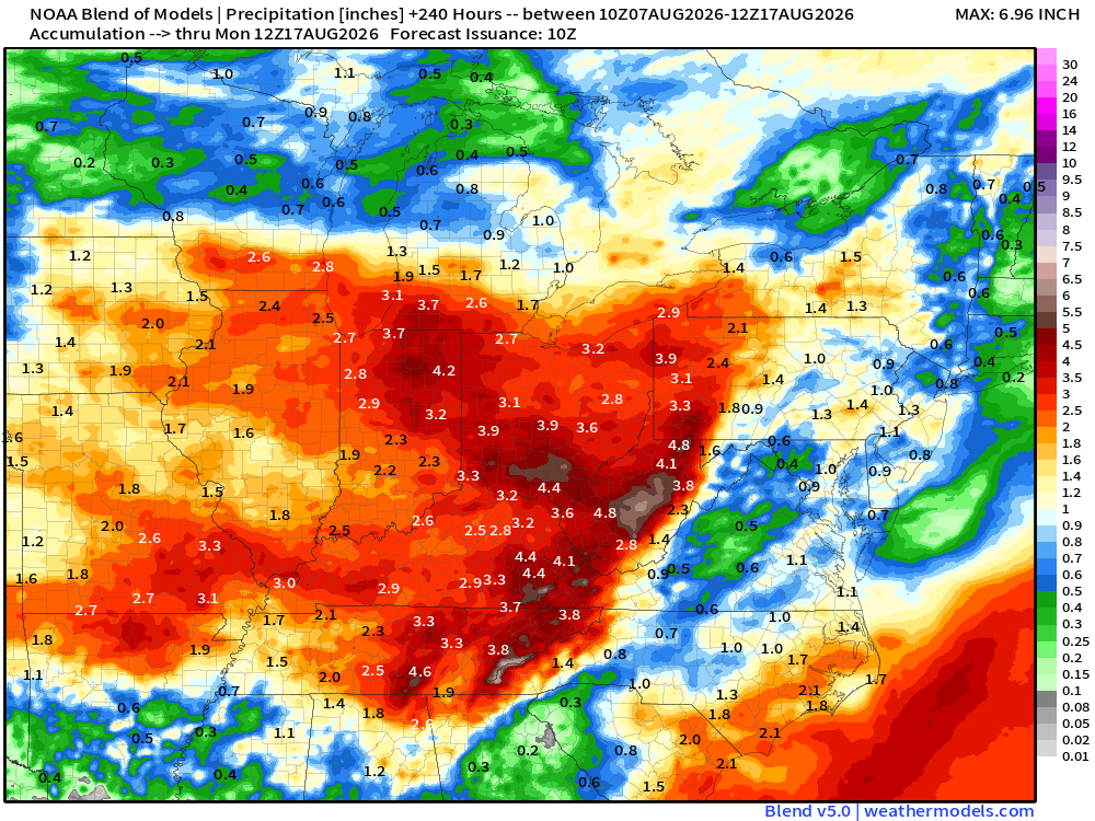
Multiple rounds of heavy rain and storms will deliver a localized flood concern next week.

Enjoy The Pleasant Conditions While We Have Them…

Updated 08.04.26 @ 6:45a Temperatures out the door this morning once again have a little ‘hint’ of autumn as we’re running anywhere from 5° to 10° below average to start…

You must be logged in to view this content. Click Here to become a member of IndyWX.com for full access.  Already a member of IndyWx.com All-Access?  Log-in here.

Scattered Showers; Storms Through Saturday Then Drier Next Week…

Updated 07.10.26 @ 7:07a We’re tracking 2 cold fronts over the upcoming 7-day period. The first cold front will move south across the region over the next 24-36 hours. Cold…

You must be logged in to view this content. Click Here to become a member of IndyWX.com for full access.  Already a member of IndyWx.com All-Access?  Log-in here.

VIDEO: Settling Back Into A More Typical Summertime Pattern…

Updated 07.06.26 @ 7:55a The week ahead will be much more “normal” by mid summer standards, including heat, humidity, and storm coverage. In fact, temperatures will run a couple of…

You must be logged in to view this content. Click Here to become a member of IndyWX.com for full access.  Already a member of IndyWx.com All-Access?  Log-in here.