February 10, 2019 archive

All-Access Sunday Evening Video Update…

Another busy weather week is dialed up for central Indiana, including flooding and accumulating snow. We also look ahead to late month and early March…

You must be logged in to view this content. Click Here to become a member of IndyWX.com for full access.  Already a member of IndyWx.com All-Access?  Log-in here.

Permanent link to this article: https://indywx.com/2019/02/10/all-access-sunday-evening-video-update/

Transition Period Set To Give Way To A Big Finish To Winter?

We don’t see any reason to alter our thinking of how the upcoming (4) weeks plays out:

This week features a transitional pattern back to a predominantly colder and snowier than average period from 2/18 through 3/10.

The MJO continues to have Phase 8 on its mind.

To no surprise, the GEFS is going right to what a Phase 8 should yield:

Days 1-5

Days 6-10

Days 10-14

With widespread cold set to once again overwhelm the pattern, the active storm track will begin to take on an increasingly snowy theme in the aforementioned period. This is a type pattern that may once again challenge cold records somewhere in the late February or early March time frame. While likely not to the magnitude of the bitter blast a couple weeks ago, it wouldn’t surprise us in the least to head back to record daily cold territory before pulling out of this pattern and heading on towards spring.

Permanent link to this article: https://indywx.com/2019/02/10/transition-period-set-to-give-way-to-a-big-finish-to-winter/

Snow Arrives By Late Morning…

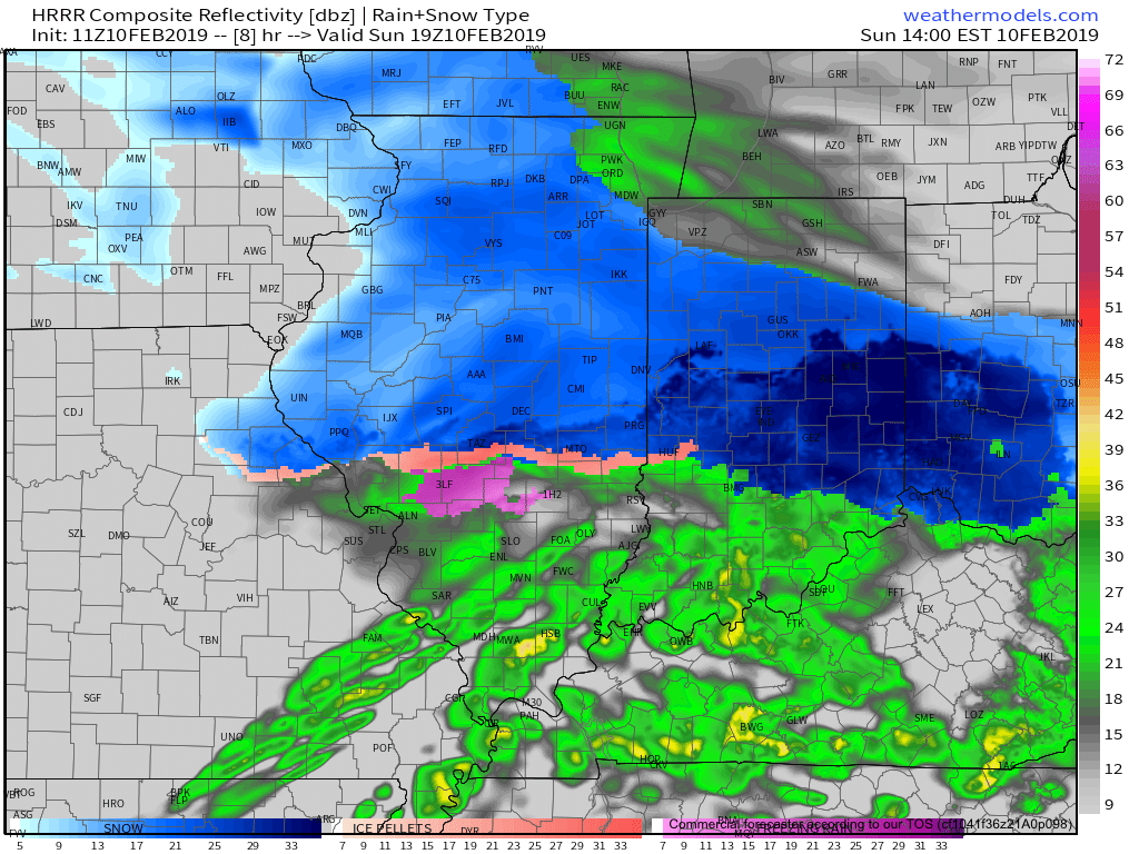
Brief: Accumulating snow and freezing rain

Forecaster: McMillan

What: Accumulating snow and freezing rain

When: Late morning into early evening

Temperatures: Lower 20s rising to around freezing by tonight

Wind: SE to S 5-15 MPH

Blowing/ Drifting: Non-existent 

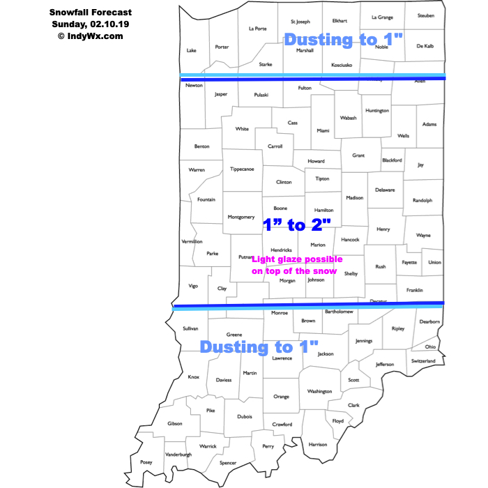
A weak disturbance will spread moisture into central Indiana as we close the weekend. Snow will reach Indianapolis and surrounding communities mid-to-late morning, continuing into the afternoon hours. Snowfall intensity will remain light with occasional moderate bursts. Banding potential will be highest north of the city, resulting in 2” totals being more common. As relatively milder air gets pulled north, a period of light freezing rain/ freezing drizzle is expected Sunday afternoon and evening.

Confidence: HighN

Permanent link to this article: https://indywx.com/2019/02/10/snow-arrives-by-late-morning/

IndyWx.com