Wednesday Morning Rambles…

I.) An unseasonably warm pattern will remain as we move into the middle of the week.  A more summer-like feel can be expected as opposed to the increasingly chilly early October air we should be dealing with.  Highs will reach the middle 80s this afternoon along with a gusty SW breeze.

II.) After a windy and warm Wednesday, scattered showers and thunderstorms will return Thursday.  Not everyone will get wet, but a few locally heavy downpours can be expected.

III.) The ridge will “flex its muscle” into early and middle parts of next week and promote an extended (and unusual) stretch of 80s.  Don’t put those shorts away just yet…

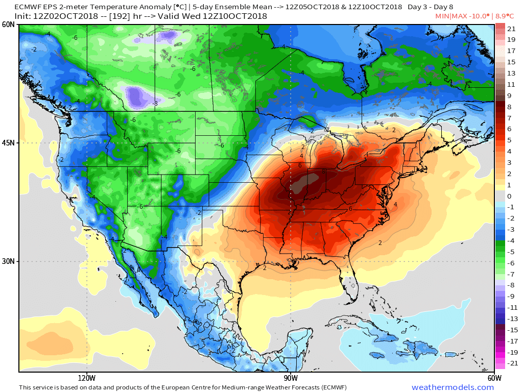
IV.) A “game changer” of a cold front will approach late next week with better chances of organized rain and storms followed by a return of more seasonal times…

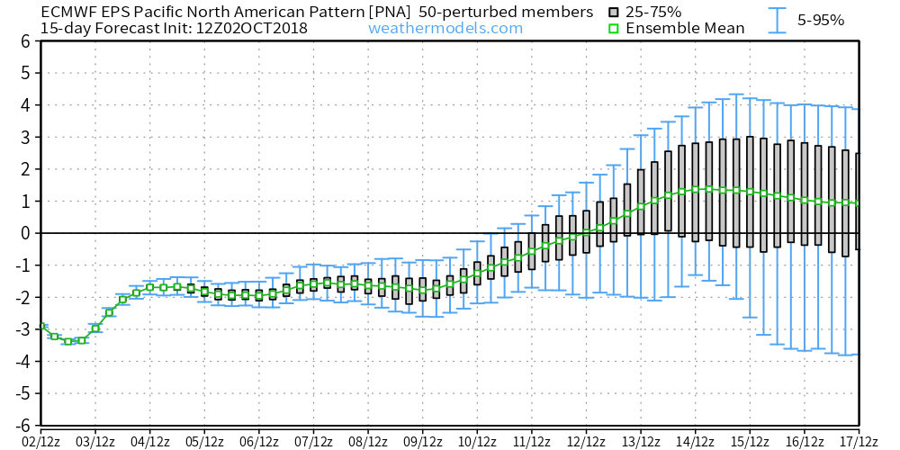
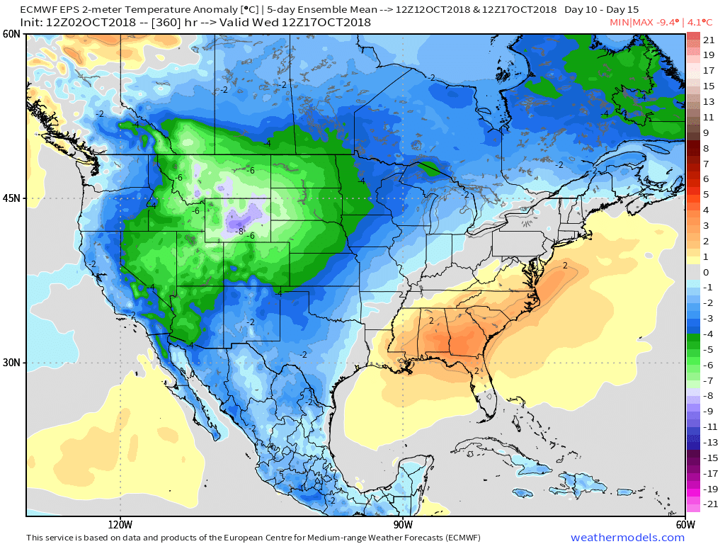
V.) Ingredients are in place for a significant shift in the pattern around the middle of October and colder times continue to look like they will return as we flip the page into Weeks 2-3.

Florence Brings Devastating Flooding To The Carolinas; Extended Dry & Warm Stretch Here…

Florence made landfall around 7:15 this morning near Wrightsville Beach, NC.  Within the past 30 minutes, a wind gust was reported to 105 MPH in Wilmington, NC.

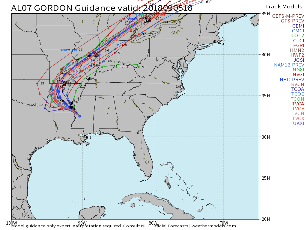
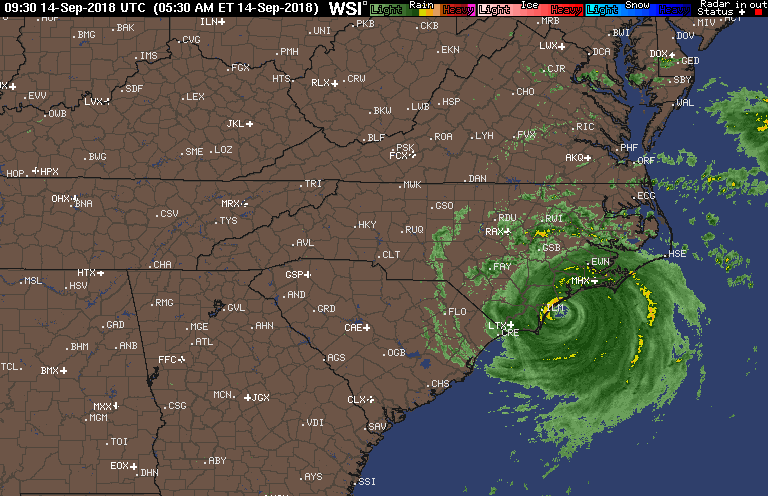
Florence will crawl through the Carolinas this weekend and spread devastating flooding well inland- 20″ to 30″. Even the high ground of the North Carolina Blue Ridge will experience severe flooding Sunday into Monday- 6″ to 12″.  These are forecast radar totals shown now through 2p Sunday.  The Blue Ridge will see heavy rain continue into Monday evening.

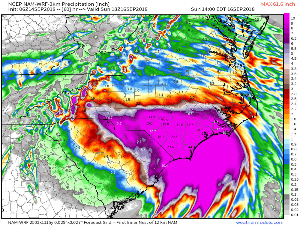
Back here on the home front, expect an extended stretch of dry and warm weather.  Plentiful sunshine can be expected as we head into the weekend along with a warming trend- mid 80s and lows in the mid to upper 60s.  High pressure will remain in firm control.

The next item of excitement for our region will be from a cold front late next week.  This will help increase shower and thunderstorm chances along with delivering cooler air next weekend.

Long Stretch Of Wet Weather Ahead…

I. Slow-moving showers and thunderstorms will begin to dissipate this evening and tonight with the loss of daytime heating.  Some area rain gauges have already picked up between 0.50″ and 1″ of rain this afternoon and this will only serve to lay the ground work for further problems moving forward.

II. A growing shield of rain will engulf northern and central parts of the state Friday afternoon.  Initially, this will mostly be of the light to, at times, moderate variety.  Additionally, we’ll notice an increasingly stiff easterly flow as the afternoon and evening wear on.  Temperatures will fall from a high in the middle 70s into the 60s late Friday afternoon and evening.

III. A frontal boundary will remain draped across central parts of the state Saturday while the remnant circulation of what once was Tropical Storm Gordon pushes closer.  As such, rainfall intensity will increase as we move through the day Saturday- particularly by evening into the overnight, on into Sunday morning.  Periods of heavy rain can be expected during this time frame.  Rainfall rates will begin to diminish Sunday PM before moisture exits stage right Sunday evening.

By the time all is said and done, widespread 3″ to 5″ rainfall totals can be expected through the heart of the state, including Indianapolis, but there will be locally heavier totals upwards of 6″ to 7″ in spots.  Flooding, unfortunately, will result.  If you live near water ways please ensure to keep close tabs on water levels and expect rapid rises Saturday into Sunday.  Have a plan in place to escape to higher ground.

IV. After a week of excessive heat and humidity, the coming cooler regime will be welcome by most.  Temperatures most of Saturday and Sunday will remain in the 60s.  At times, “wind chills” (haven’t used that term in a while) will fall into the 50s.

Warmer times will return late next week as ridging re-establishes itself.

Wednesday Evening Rambles: Cool, Wet, & Blustery Weekend On Deck…

Gordon’s remnant moisture will claim headlines through the weekend.

I.  A cold front will approach Indiana Thursday and result in increased cloudiness AND a better chance of scattered showers and thunderstorms- especially during the afternoon and evening hours.  Though still warm and humid, temperatures will begin a “step down” process to eventually MUCH cooler readings this weekend.

II.  Unsettled weather will continue Friday into Saturday as the surface front settles south.  As an increasingly blustery easterly flow takes hold across central Indiana, cooler air will continue to “ooze” into the state.  Highs shouldn’t make it out of the 70s Friday with considerable cloudiness and showers around.

III.  Unseasonably cool air will be with us Saturday (most of the afternoon will be spent in the 60s for the majority of central IN, especially north of I-70). A stiff easterly flow and showers will continue.

IV.  The remnant moisture of Gordon will creep closer to the region Saturday PM before setting up shop Saturday night into Sunday evening.  This is the most concerning period for potentially excessive rainfall rates and localized flooding.  We still have time to watch things unfold, but the idea here is that widespread 2″ to 4″ totals are likely with locally heavier totals.  This is “beefed up” from this morning’s call of 2″ to 3″.  Stay tuned, especially if you live near water ways.

V.  Finally, the tropical moisture will surge northeast Sunday night and Monday and a cold front will sweep through the region.  This will set up a much drier and very pleasant period as we open up the new work week.

Summer Feel Returns…

The past (10) days have been particularly pleasant across central Indiana, especially by late-July standards.  80% of the period has featured temperatures at, or below, normal, and the past couple of days have been impressively cool.  Hat tip to Sean Ash (@SeanWTHR) for the most recent stat: “Just the 12th time in 147 years of back-to-back July days in Indianapolis with a high of 72° or below.”  Rainfall has been plentiful across central Indiana, including widespread amounts of 1″ to 2″ with some reports of 3″ to 5″ over the past 48 hours.

After a warm open to the month, July has taken on a significantly cooler side as of late: Graphic courtesy of Midwestern Regional Climate Center

As we rumble into August, you knew that summer feel had to return, right?! 🙂

Forecast models are in agreement that an upper level ridge will expand across the Great Lakes region in the 6-10 day period.  This will deliver a return of warm-to-hot and muggy conditions to central Indiana- beginning this weekend into next week.

GEFS Days 6-10: Graphic courtesy of Tropicaltidbits.com
EPS Days 6-10: Graphic courtesy of Tropicaltidbits.com

While the next couple of days will continue the cooler than normal theme, temperatures will return to a “summery” feel over the weekend, continuing into next week.  Along with the warmer air will also come increasing humidity.  In short, we recommend incorporating a pool visit (or two) into your weekend schedule.  Highs will return into the upper 80s to around 90° and overnight lows will dip into the upper 60s to around 70°.  While warmer and certainly more humid than we’ve been, we still believe the hottest of the season is behind us (highs of 94° on July 4th and 14th).

Highs will top out a couple degrees either side of 90 this weekend. Graphic courtesy of weathermodels.com

While a more summer-like feel will replace the unseasonably cool close to the month and open to August, it sure looks like the hotter regime will be transitional.  The general consensus from data points towards a return of seasonable to below average temperatures along with a continuation of active times as mid-month approaches…