Friday Morning Rambles: Pattern Discussion To Close Out The Year…

Updated 12.22.23 @ 7:15a

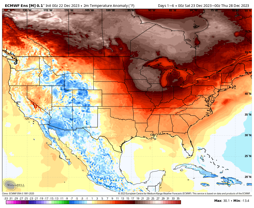
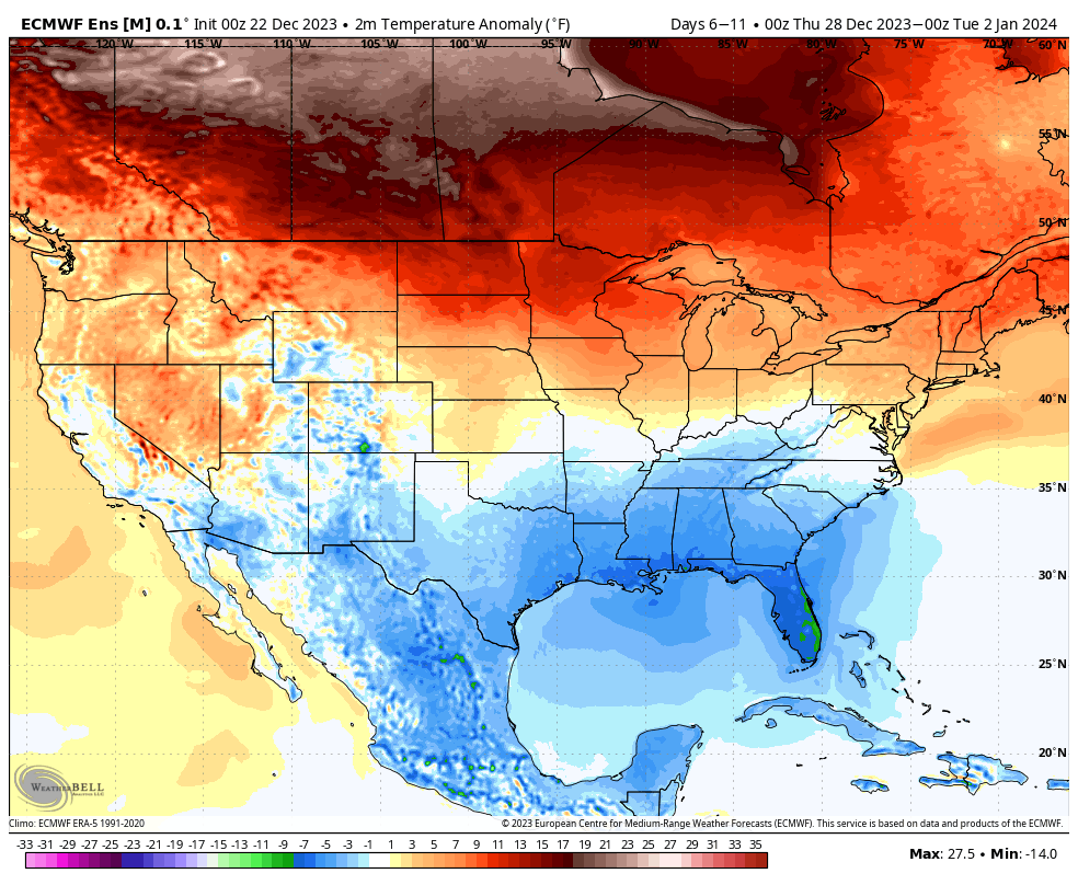
We open the period with widespread milder than normal temperatures in the 1-6 day period. Greatest anomalies are centered over the upper Midwest. Note the step down to a pattern, locally, that’s more seasonable if not slightly cooler than normal to close the year and open 2024. That’s the emphasis we want to drive home- though turning colder, we’re not in the camp that our immediate region will have to deal with any sort of arctic air anytime soon.

Days 1-6
Days 6-11
Days 10-15

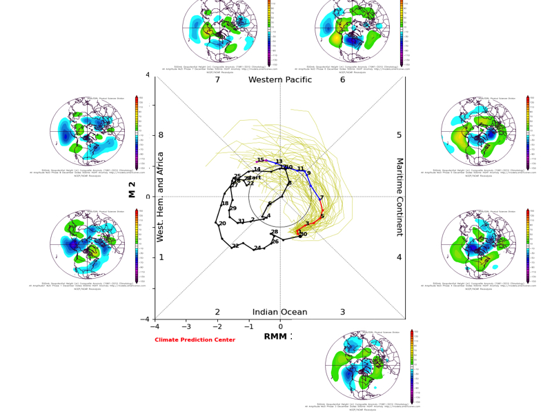
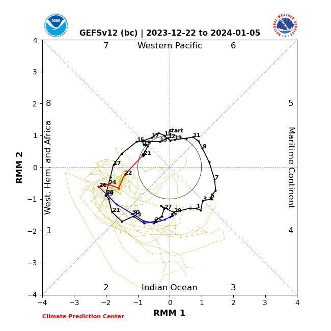
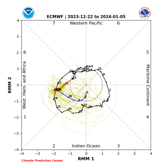
You know we’ll be keeping close eyes on the Madden Julian Oscillation over the next few days. Should the American guidance come to fruition, then a warmer pattern is certainly alive and kicking after the cooler pattern to open January. Interestingly this morning, early trends are more in favor of the European camp, but it’s still early and we’ll need to monitor closely through the Christmas holiday.

American guidance isn’t as bullish moving into Phase 3 early January with the overnight update.

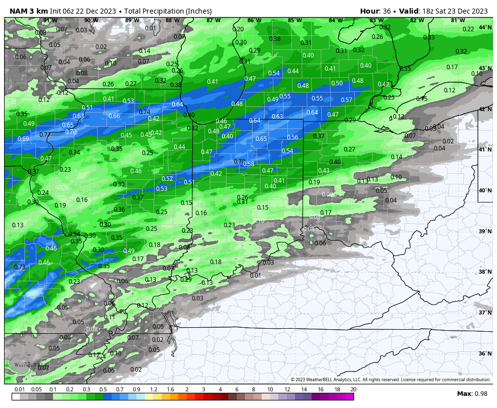
In the shorter term, morning showers will transition to more of a widespread light rain across the northern half of the state later this afternoon and tonight. Some northern Indiana rain gauges could surpass 0.50″ during this time period from “round 1” of more widespread rain.

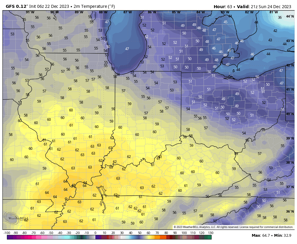
Pesky light showers will be around Saturday, but this will be more of a nuisance than anything else. Widespread measurable rain isn’t anticipated. We then flip the calendar to Christmas Eve and the forecast continues to improve. We even anticipate some sunshine to couple with the unseasonably mild air and breezy southerly winds. Highs approaching 60° can be expected as Santa loads up his sleigh.

More widespread rain arrives Christmas Day, especially by late morning and during the afternoon. This is the timeframe when we expect greatest coverage and heaviest rainfall rates of the period. Storm total rainfall of 0.50″ to 1″ still looks like a good bet.

Colder air works in behind the storm and left over “wrap around” precipitation will begin to mix with and change to snow Thursday.

The downhill slide to more seasonable and slightly colder than normal temperatures continues as we close out the year…

Dinnertime Rambles: Talking Snow, Weekend Storm, And Holiday Pattern…

Updated 12.04.23 @ 5:21p

1.) Our clipper system is still on track to deliver a wintry mix of a cold rain and wet snow to central Indiana during the predawn hours Tuesday, continuing into the mid and late morning. We don’t have any changes from this morning’s video update. Thinking is that this is primarily a wet snow event from in and around Indianapolis and points north, including the potential of a coating to a dusting of snow in/ around the city with 0.50″ to 1″ type accumulation of wet snow across north-central Indiana (including northern Indy ‘burbs, such as Whitestown, Zionsville, Westfield, Carmel, and Fishers). Pavement issues aren’t anticipated due to the marginally cold temperatures in place and recent mild air, but slushy accumulation on grassy and elevated surfaces is likely in the areas mentioned above.

Most of the “system” precipitation should be out of here by lunchtime with a chance of a few scattered snow showers returning to north-central Indiana and into Indianapolis Wednesday morning with the weak cold air advection (CAA).

2.) After a seasonably chilly midweek, temperatures will “zoom” into the 50s and even approach 60 before we close the work week out. This is in response to an aggressive southwesterly air flow ahead of an approaching and strengthening surface low pressure system that already has the weather community “buzzin'” several days in advance. While the pattern is conducive for a rapidly deepening area of low pressure advancing from the Ark-la-tex region northeast across the Ohio Valley and Great Lakes, there are still many more questions than answers before we can provide anything concrete with respect to p-type, including potential snow numbers.

The hesitancy in leaning in stronger to this event from a winter perspective, locally, is the lack of cold air available to tap into. That’s not to say this storm will have to generate all of the cold on its own, but we’ll have to have a rapid strengthener to help aid in the cold production if anything meaningful is to transpire on the winter front. All of that said, it’s safe to say that a widespread, wind-whipped precipitation event is becoming increasingly likely this weekend. While the initial lean is still mostly “wet vs. white” for central Indiana, we’ll be watching trends very carefully.

3.) With each passing day, we receive more questions on the weather pattern around the holidays, and understandably so. The key to a sizable shift to more sustained cold and winter weather opportunities lies squarely on the MJO, in our opinion. I’ll include the image we posted here last week below showing the overall MJO evolution into the 2nd half of December. It’s certainly not unreasonable to think that the progression into the colder phases should happen when you extrapolate this out.

Long story short, we have no changes in our idea of a colder shift taking place with the overall pattern around (give or take a day or 2) 12/20.

Tuesday Morning Rambles: A Much More Active Pattern Takes Foot…

Updated 11.28.23 @7:16a

The coldest air of the season is greeting us out the door this morning, complete with snow flurries and wind chill values around zero. Safe to say that the heavy winter gear is needed today as highs struggle to crack 30° later on.

We’re waking up to 10s this morning with wind chill values near 0°.
Snow flurries and scattered light snow showers compliment the arctic intrusion this morning. No accumulation of significance is expected.

The upper pattern will transition to a milder (no blow torch by any means) and more active regime as we navigate the next 6-10 days. Most, if not all, storm systems will feature “wet vs. white” weather here over this particular time period.

Dry times return Wednesday only to give way to increasing clouds and widespread rain Thursday PM into Friday. The overall gloomy and damp pattern will prevail over the weekend and into early next week. Needless to say, enjoy whatever sunshine you can get later today and Wednesday.

Wetter than normal times return late week into early Week 2.

It continues to look like the potential is there for more appreciable cold to get back involved with the pattern after mid-month and especially closer to the holidays.

Saturday Morning Rambles: A “Bookend” Forecast…

Updated 11.25.23 @ 9:33a

We’re waking up to cold (lows bottomed out in the middle 20s for most central Indiana neighborhoods) but dry conditions. While we’ll deal with more clouds today, dry conditions will hold today and tonight.

A weak system will move through the Ohio Valley Sunday with a wintry mix of wet snow and a cold rain across central Indiana, mostly rain downstate, and all snow across north-central and northern Indiana. Sunday will dawn dry but light precipitation will overspread the state from west to east through the mid morning hours. We don’t envision any sort of snow accumulation with the exception of far western central Indiana (dusting) northeast into the northern 1/3 of the state (1”-2” amounts on grassy and elevated surfaces). Generally speaking we think the accumulation potential is greatest from Rockville to Kokomo, and up to Fort Wayne. Light precipitation will end as a brief period of light snow Sunday night into Indianapolis but “light” is the key word and we don’t expect any accumulation concerns in the city, itself.

The coldest air so far this season blows into town as we open the work week. In fact, highs may struggle to reach freezing Tuesday, including morning lows into the 10s.

November will close out on a colder than normal note.

After Sunday, from a precipitation perspective, we’re talking about a very dry and quiet regime until we get to Friday. We’ll close the work week with a new storm system that will deliver a rainy Friday.

By this point, a transition to milder times will be underway so we don’t expect any sort of p-type challenges with this particular system.

Models Trend More Organized…

Updated 11.22.23 @ 3:03p

We’ve been keying in for several days on the energy that will lead to a Thanksgiving and Black Friday Winter Storm for the Rockies, and eventually a swath of accumulating snow into the Plains over the holiday weekend. To no surprise, modeling continues to trend more organized with this energy as it moves across the Plains and into the Ohio Valley this weekend. The time we’re monitoring for potential wintry impacts across central Indiana come early Sunday morning, continuing into the afternoon.

As bullish as we’ve been on this trending towards a more substantial system, capable of producing snow, locally, we remain confident that this won’t be some sort of significant winter storm. Why? Pattern recognition on both fronts. That said, the potential of a light snow accumulation across central Indiana Sunday is very much alive and kicking as of this evening. Know that we’ll be here right through the holiday and the weekend tracking the latest and will continue to keep you posted moving forward.

Regardless if we receive snow or not, the coldest air so far this season is on deck early next week.

Models continue to trend more organized with our holiday weekend system, potentially capable of the 1st widespread snow of the season for central Indiana.