Category: Unseasonably Warm
 Highlights:
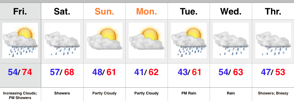
- Rain moves in later today-Saturday
- Cooler second half of the weekend
- Heavy rain event next week
High pressure will give way to an approaching cold front later today and Saturday. Showers will accompany the front and may spread into western IN as early as this evening before continuing to advance east tonight. Most of the rain should fall through the first half of Saturday, but we’ll maintain a mention of showers up until the front passes Saturday night.
Cooler, drier air will move in Sunday and to open the new work week. High pressure will supply a return of sunny, ideal fall conditions.
As we progress deeper into the week, another cold front will team up with moisture from the remnants of Patricia to provide a much needed soaking. We forecast skies to cloud up Tuesday with rain developing by evening. Periods of heavy rain can be expected Tuesday night into Wednesday before turning more “showery” in nature. Much cooler air and blustery conditions can also be expected Thursday.
Upcoming 7-Day Rainfall Forecast: 1.75″ – 2.25″
Permanent link to this article: https://indywx.com/much-wetter-cooler-pattern/
 Highlights:
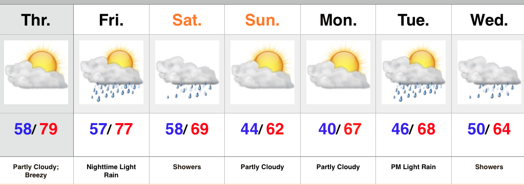
- Dry, warm, and breezy in the short term
- Weekend rain chances
- Better rain chances next week
The ups and downs of fall continue. It was only a few days ago temperatures were in the 20s and widespread frost and freeze conditions were felt across central IN. Flip forward to Thursday and some neighborhoods will flirt with the 80 degree mark with a gusty SW wind in place. Dry weather will continue through the daytime Friday before we introduce shower chances Friday night. Rain chances continue Saturday.
A cold front will sweep through the area Saturday night and provide a more fall-like feel for the second half of the weekend with increasingly sunny skies as the day progresses.
Our next weather maker will come in the form of a cold front the middle of next week and enough Gulf of Mexico moisture may get entrained into the system to present a better threat of more significant rains than what we’ve seen over the past month, or so. We’ll keep our fingers crossed. Model solutions as of now vary from an absolute deluge (GEM and European) to more of a 0.5″-1″ type event. For now, we’ll “split the difference.”
Upcoming 7-Day Rainfall Forecast: 1″ – 1.5″
Permanent link to this article: https://indywx.com/dry-weather-continues-for-now/
 Highlights:
- Breezy open to the work week
- Moderating temperatures
- Weekend rain chances
Two back-to-back freezes were felt across central IN over the weekend, including several reports of middle to upper 20s in neighborhoods away from the city. As we open the work week, our air flow will shift to the SW and help boost temperatures with wind gusts up to 30 MPH Monday afternoon. Dry conditions will prevail until Wednesday when an isolated shower/ sprinkle will be possible.
Better rain chances are expected this weekend as a cold front moves in. Modeling suggests this boundary may be able to tap into just enough Gulf moisture to allow for more widespread rain coverage than what we’ve seen recently. We’ll keep our fingers crossed.
Upcoming 7-Day Rainfall Forecast: 0.25″ – 0.50″
Permanent link to this article: https://indywx.com/moderating-trend/
A tranquil and warm start to the week (today and Monday) will take a bit of a hit for mid week as the first of two waves of cooler air…
You must be logged in to view this content. Click Here to become a member of IndyWX.com for full access. Already a member of IndyWx.com All-Access? Log-in here.
Permanent link to this article: https://indywx.com/colder-air-arrives-late-week/
 Highlights:
- Mostly dry theme continues
- Get used to the term “breezy!”
- Much cooler air coming
We couldn’t have asked for better weather for a Saturday and, thankfully, we’ll experience a repeat tomorrow (tack on a few degrees for afternoon highs). Breezy SW winds (gusts upwards of 30 MPH) will kick temperatures up to near 80 Monday afternoon before a cold front sweeps through the region Monday night. While an isolated shower is possible Monday, most of central IN will remain rain-free. Cooler air will arrive Tuesday and Wednesday.
A stronger cold front will move into the region Friday. Like our early week front, this one, too, will be moisture-starved. Windy conditions and MUCH cooler air will be the big deal going into next weekend. Most communities will experience their first frost Saturday and/ or Sunday morning.
Upcoming 7-Day Rainfall Forecast: Trace to 0.10″
Permanent link to this article: https://indywx.com/winds-of-change/
