Category: GFS

Catching Up On A Tuesday Evening…

Several interesting weather items are on the docket and each will have to be dealt with as they come over the course of the upcoming 7 days.  Some of the headlines include a brief warm-up Saturday, weekend rain that could include a tropical connection Sunday, and another big shot of October-like chill next week.

While we have a few more days of below normal temperatures in front of us, we eye at least one day where temperatures will manage to climb above normal and that’s Saturday.  All indications still suggest we’ll be very close, if not a degree or two higher, than the 80 degree mark along with a nice southwest air flow in place Saturday.  All-in-all, it’ll be a great day to take care of any early-autumn yard work that’s needing to get done.

Changes brew Sunday as a cold front draws near.  This is where questions lie and they actually have to do with Tropical Storm Odile (currently all the way to our southwest over the central Baja California peninsula region).  Odilemoisture

While the GFS and European forecast models still aren’t interested in “welcoming” Odile’s moisture into the region, we note the Canadian model does suggest some tropical moisture, courtesy of Odile, gets entangled along the front Sunday.  We’ll continue to keep a close eye on things and monitor the forecast data accordingly moving forward through the back half of the work week.


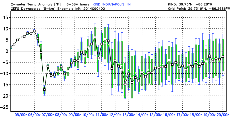
The other item of interest has to do with yet another big blast of autumn air that will have things feeling very much like October around these parts come early next week.  The above average temperatures Saturday will hang around just for the day as yet another unseasonably chilly air mass moves into the area Monday into Tuesday of next week as a significant trough develops over the east with an impressive western ridge in place.  f156


Note the GEFS and Canadian show the return of the unseasonable chill next week.  Keep those jackets handy.  Early indications would suggest this type air mass is plenty capable of highs in the upper 50s/ lower 60s and overnight lows in the upper 30s/ lower 40s during the height of the chill (most likely Tuesday).  Stay tuned…

2014091600_054@007_E1_north@america_I_NAEFS@TEMPERATURE_anomaly@probability@combined@week2_198gefs_t2anom_by5_conus_45


Permanent link to this article: https://indywx.com/catching-up-on-a-tuesday-evening/

Nice Now, But Stormier Times Loom…

What a beautiful Sunday underway across central Indiana. We made the suggestion earlier today to get outside and watch the opening Sunday of NFL if at all possible (btw, we…

You must be logged in to view this content. Click Here to become a member of IndyWX.com for full access.  Already a member of IndyWx.com All-Access?  Log-in here.

Permanent link to this article: https://indywx.com/nice-now-but-stormier-times-loom/

Hot And Humid Before A Big Weekend Cool Down…

Thr.

Fri.

Sat.

Sun.

Mon.

Tue.

Wed.

 Status-weather-showers-day-icon

 Status-weather-showers-day-icon

 Status-weather-showers-day-icon

 Status-weather-clouds-icon

 Status-weather-clouds-icon

 Status-weather-clouds-icon

 Status-weather-showers-day-icon

65/ 87

69/ 89

59/ 73

52/ 73

51/ 76

52/ 77

57/ 76 

Watching Storms To Our Northwest This Morning…Today is a bit of a tricky forecast.  A complex of showers and thunderstorms is tracking through northern Illinois this morning and we’ll monitor this area of showers and storms in the event it begins to shift south of a due east track.  Additionally, outflow boundaries from this complex may trigger additional development of showers and thunderstorms later today.  Best rain/ storm chances should remain across northern Indiana, but we’ll keep an eye on things.  With all of that said, we think most folks here across central Indiana will remain rain-free, including lots of sunshine today.

Cold Front Ushers In A Much Cooler Weekend…A cold front will move through the region early Saturday morning. Ahead of this boundary, a broken line of strong to severe thunderstorms will likely blow through central Indiana Friday night.  We continue to fine tune timing, but thinking at this point highlights 8p to 1a Friday night and Saturday morning (we’ll “tighten” that time line up later tonight).

A few left over showers are possible into Saturday along with a MUCH cooler, fall-like, feel that will continue into next week!

Big Blast Of Cool Air Mid Month…Good model agreement remains on a big blast of cool air blowing in later next week.  Once again, rain and storms will remain in the forecast as the strong cold front blows through.  Behind the boundary, some truly chilly air would arrive… More details to come as we move forward, but it may be a good idea to go ahead and pull those jackets and sweaters out if you haven’t already.

7-Day Precipitation Forecast:

  • 7-Day Rainfall Forecast: 0.50″ – 1.00″
  • 7-Day Snowfall Forecast: 0.00″
GEFS temperature anomalies over the next two weeks show the 1-2 punch of cool air coming. Time to think about pulling out those jackets!

GEFS temperature anomalies over the next two weeks show the 1-2 punch of cool air coming. Time to think about pulling out those jackets!

Permanent link to this article: https://indywx.com/hot-and-humid-before-a-big-weekend-cool-down/

Improving Weather Through The Day…

Tue.

Wed.

Thr.

Fri.

Sat.

Sun.

Mon.

 Status-weather-showers-day-icon

 Status-weather-clouds-icon

 Status-weather-clouds-icon

 Status-weather-showers-day-icon

 Status-weather-clouds-icon

 Status-weather-clouds-icon

 Status-weather-clouds-icon

67/ 80

60/ 83

64/ 87

69/ 89

55/ 73

49/ 73

51/ 76 

Decreasing Rain Coverage; Increasing Sunshine…A shield of moderate to heavy rain encompassed the state during the overnight.  This shield of rain is slowly moving east, southeast and we’ll be looking at improving weather through the day.  There’s still the chance of a widely scattered thunderstorm late morning or early afternoon as a frontal boundary slides through the region.

Sunny Days…As we progress through the mid and late week stretch, we’ll enjoy dry skies and plentiful sunshine.  Normal lows and highs are in the lower 60s and lower 80s this time of year, so we’ll be very close to that Wednesday before moderating temperatures take us warmer than average to wrap up the work week.

Late Week Cold Front; Autumn Feel This Weekend…A cold front will slice into the warm and humid air mass Friday evening and lead to the possibility of a broken line of strong to potentially severe thunderstorms.  A MUCH cooler air mass will then invade the region behind the boundary, leading to a true fall-like feel this weekend!

7-Day Precipitation Forecast:

  • 7-Day Rainfall Forecast:  0.50″ – 0.75″
  • 7-Day Snowfall Forecast: 0.00″

John Salewicz sent us this beautiful sunrise photo Saturday morning before storms invaded portions of central Indiana.  Thanks, John!

BwSIn32CIAAqYL7


Are you craving cooler air to go along with that early season pumpkin spice latte? You'll be in luck this weekend as a true fall-like air mass invades...

Are you craving cooler air to go along with that early season pumpkin spice latte? You’ll be in luck this weekend as a true fall-like air mass invades…

Permanent link to this article: https://indywx.com/improving-weather-through-the-day/

Beneficial Steady Rains Coming Overnight…

I’m just getting settled back in from Auburn, AL, but wanted to update a couple of items before a complete 7-day post in the morning.

1.) Rain is continuing to become more widespread to our southwest and will overspread southern and central Indiana during the overnight into the wee morning hours Tuesday.  Most communities will accumulate 0.50″-1.00″ of needed rain, but a few locally heavier totals (closer to 2″) can be expected.  The HRRR forecast rainfall totals by 11am (when most of the rain will be ending across even our eastern counties) looks solid and we agree with this for the most part.  Note the heavier forecast totals across southwestern Indiana.

hrrr_t_precip_indy_16

2.)  A cold front will sweep the state Friday night into Saturday morning and result in a MUCH cooler weekend.  Temperatures will fall to well below normal levels (by 5-8 degrees on average) over the weekend and result in a perfect, early fall-like, feel!  Highs Saturday through Monday will likely only range in the lower to middle 70s with overnight lows in the lower 50s (a few readings into the 40s can be expected outside the city).

gfs_t2max_a_f_conus2_51

Permanent link to this article: https://indywx.com/beneficial-steady-rains-coming-overnight/