Category: GFS

Wednesday Evening Video Update…

Good afternoon and welcome into IndyWx.com!  Here’s a quick video brief concerning the weather situation across central Indiana over the course of the week ahead. By the way, if you’re…

You must be logged in to view this content. Click Here to become a member of IndyWX.com for full access.  Already a member of IndyWx.com All-Access?  Log-in here.

Permanent link to this article: https://indywx.com/wednesday-evening-video-update-2/

Weekly Outlook: Big Weather Changes…

October, month-to-date, shows a reflection of cool anomalies across the Great Lakes region and wetter than normal across the central and Tennessee Valley. The week will get off to an…

You must be logged in to view this content. Click Here to become a member of IndyWX.com for full access.  Already a member of IndyWx.com All-Access?  Log-in here.

Permanent link to this article: https://indywx.com/weekly-outlook-big-weather-changes/

The Ups And Downs Of Autumn…

It simply doesn’t get much better than this!  Wall-to-wall sunshine and temperatures in the lower to middle 70s across central Indiana this afternoon…  If you aren’t outside now, we are making it mandatory to get outside upon reading this!  🙂  Enjoy, as the ups and downs of autumn will send us in an opposite direction late in the upcoming week.

Forecast models are coming into better agreement on the evolution of things heading into next weekend.  While there are still a couple of important differences between the GFS and European, we’re growing increasingly confident on a much colder feel next weekend.

Note the latest GFS operational run stacked atop individual ensemble members.  Needless to say, there’s ensemble support and leads to a higher confidence forecast in the mid range of a deep trough carving itself out across the Mid West and East.  Unseasonably cold air would be associated with this.

GFS


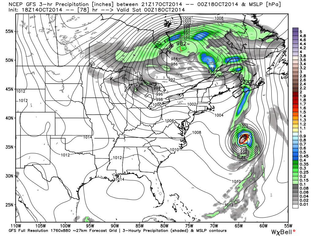
Meanwhile, the European model is more extreme, suggesting a cut off feature develops across the southeast before helping spawn a Nor Easter and leading to high ground accumulating snows from the southern Appalachians northeast along the spine of the mountains.

Again, there’s ensemble support (left) to go with the operational run (right).

EC1

EC2

Whether or not we get some sort of cut off low pressure system to really dig in and help generate high ground snow is up for debate and will be the focal point for many for the upcoming week.

Back here on the home front we’re becoming increasingly confident on the first push of wintry type air here next weekend and timing will have to be fine tuned as we move forward, including the all-important Halloween forecast.  The type air mass moving in will most likely put an end to the growing season across these parts as it’s likely capable of producing multiple below freezing nights.

Much more in the days ahead!  In the meantime, enjoy what we have in front of us now!

Permanent link to this article: https://indywx.com/the-ups-and-downs-of-autumn/

Much Needed Dry Time On Deck For #Harvest14…

Despite another day of showery, damp weather Wednesday, the overall “trend is our friend” in the short to mid range as a much drier pattern develops.

Drier, cooler air will penetrate into the Mid West and Ohio Valley as the weekend draws closer.

gfs_precip_mslp_east_19


gfs_precip_mslp_east_27


gfs_precip_mslp_east_43


It’s important to note the GFS has support on the drier trend to include some other highly respected mid range model suites such as the Canadian and European.

The next round of rain arrives Tuesday with reinforcing chilly air that could deliver mid and late week frost and freeze conditions for parts of the region.  The Canadian is a little more bullish on rainfall totals when stacked against the GFS and European.  We’ll continue to monitor.

gfs_precip_mslp_east_51


cmc_precip_mslp_east_26


Regardless of Tuesday rain, we’ll quickly return to a dry regime by the middle of next week.

The Climate Prediction Center (CPC) agrees on a drier pattern in the mid range.

814prcp.new


Latest forecast rainfall totals off the GFS model suggest amounts of 0.50″, or less, across the region over the upcoming 7-days, and it’s important to note half of that likely falls Wednesday with showers associated with swirling low pressure around the region.

gfs_total_precip_east_30


Note the cooler trend developing in the 7-day, as well:

KIND_2014101418_tx_192

If your company depends on snow removal or other types of winter weather, please send us an e-mail for customized winter weather consulting at bill@indywx.com.

Permanent link to this article: https://indywx.com/much-needed-dry-time-on-deck-for-harvest14/

Carefully Watching Monday Night/ Tuesday For Storm Potential…

While rain and chilly air are the headlines as we wrap up the work week and open another important college football weekend (my anticipation is building rapidly for my beloved Tigers taking on a dangerous MS. State squad Saturday afternoon- WAR EAGLE, btw), our attention is continuing to focus in on the potential of strong to severe thunderstorms Monday night and Tuesday morning across the region.

Forecast models continue to suggest strengthening low pressure will track northeast from MO into IL and MI Monday night into Tuesday morning.

gfs_slp_precip_conus_19

f96

The region will briefly get into a warm and humid environment Monday and Monday night (plenty capable of fueling strong to severe thunderstorm development).  Temperatures in the 70s will combine with dew points in the low to mid 60s.

gfs_dew2m_east_33

A ribbon of precipitable water values will approach 2″ across the state Monday night.  This supports heavy and locally flash flood producing rainfall.  Forecast models continue to key on additional Monday-Tuesday rainfall in the 1-2″+ range.

gfs_pwat_mslp_east_35

We’ll continue to closely monitor the data as we move forward, but at this early juncture, make a mental note to be weather-aware Monday night into Tuesday morning as strong to severe thunderstorm potential develops.

Permanent link to this article: https://indywx.com/carefully-watching-monday-night-tuesday-for-storm-potential/