Beneficial Steady Rains Coming Overnight…

I’m just getting settled back in from Auburn, AL, but wanted to update a couple of items before a complete 7-day post in the morning.

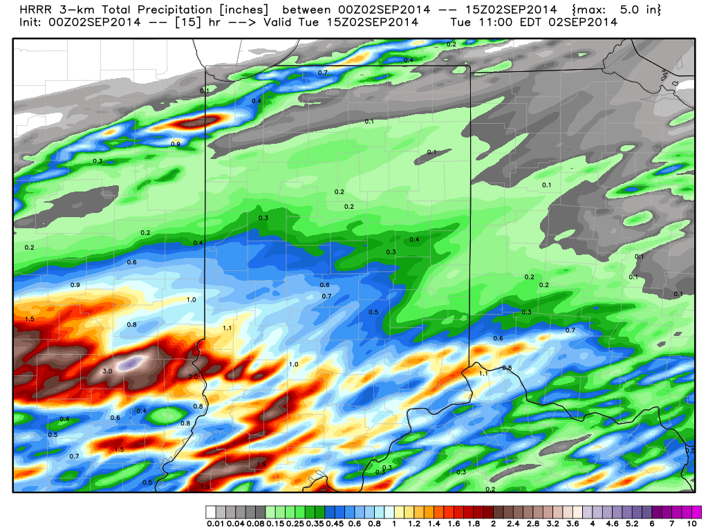
1.) Rain is continuing to become more widespread to our southwest and will overspread southern and central Indiana during the overnight into the wee morning hours Tuesday.  Most communities will accumulate 0.50″-1.00″ of needed rain, but a few locally heavier totals (closer to 2″) can be expected.  The HRRR forecast rainfall totals by 11am (when most of the rain will be ending across even our eastern counties) looks solid and we agree with this for the most part.  Note the heavier forecast totals across southwestern Indiana.

hrrr_t_precip_indy_16

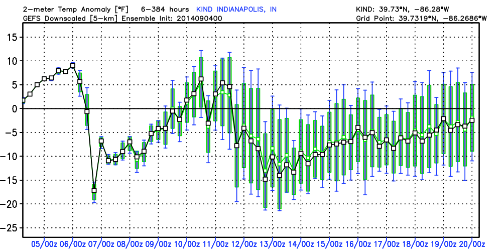
2.)  A cold front will sweep the state Friday night into Saturday morning and result in a MUCH cooler weekend.  Temperatures will fall to well below normal levels (by 5-8 degrees on average) over the weekend and result in a perfect, early fall-like, feel!  Highs Saturday through Monday will likely only range in the lower to middle 70s with overnight lows in the lower 50s (a few readings into the 40s can be expected outside the city).

gfs_t2max_a_f_conus2_51

Storms And Heat…

Good morning and happy Thursday! This will be a quick post this morning before a more extensive update and 7-day outlook later this evening. The SPC highlights our region for…

You must be logged in to view this content. Click Here to become a member of IndyWX.com for full access.  Already a member of IndyWx.com All-Access?  Log-in here.

Unsettled Couple Days Ahead Before A Taste Of Fall By Mid Week…

Scattered to numerous showers and thunderstorms continue to impact central Indiana, along with localized flash flooding (precipitable water values are currently above 2″ in spots and suggest localized very heavy…

You must be logged in to view this content. Click Here to become a member of IndyWX.com for full access.  Already a member of IndyWx.com All-Access?  Log-in here.

Mid And Late Week Questions…

Mon.

Tue.

Wed.

Thr.

Fri.

Sat.

Sun.

 Status-weather-clouds-icon

 Status-weather-showers-day-icon

 Status-weather-showers-day-icon

 Status-weather-showers-day-icon

 Status-weather-showers-day-icon

 Status-weather-clouds-icon

 Status-weather-clouds-icon

62/ 85

62/ 84

63/ 81

63/ 80

62/ 82

59/ 83

62/ 86 


Dry Start To The Week…High pressure will remain in control of our weather today and supply lots of sunshine and seasonable temperatures.

Rain Chances Increasing…A cold front will drop closer to the region Tuesday and will help to serve as the trigger in widely scattered shower and thunderstorm development Tuesday afternoon.  Mid week is where our questions lie and they have to do with just how far the front makes it before stalling.  A combination of the GFS, European, and Canadian forecast models shows a variety of results.  The European is most progressive and dries the region out quickly mid week with high pressure building into the area.  The Canadian is the exact opposite as it paints a wide swath of heavy rain through the heart of the state (2″ type rains through late week).  Finally, the GFS is in between the two.  We think the GFS has the best idea as of now, but we’ll keep a close eye on things as we move through the next couple days.  Stay tuned.

Pleasant Weekend…We’re confident on a weekend that should feature beautiful late-summer weather conditions- lots of sunshine, seasonable temperatures, and low humidity!

7-Day Precipitation Outlook:

  • 7-Day Rainfall Forecast: 0.50-1.00″
  • 7-Day Snowfall Forecast:  0.00″
Forecast radar shows widely scattered showers and thunderstorms returning Tuesday. This is just the beginning of an unsettled few days ahead mid week.