Category: Forecast Discussion

Spring Like Today, But Keeping A Close Eye On Sunday…

Fri.

Sat.

Sun.

Mon.

Tue.

Wed.

Thr.

 Status-weather-showers-day-icon

 Status-weather-clouds-icon

 Status-weather-snow-scattered-icon

 Status-weather-clouds-icon

 Status-weather-showers-scattered-icon

 Status-weather-snow-scattered-day-icon

 Status-weather-clouds-icon

32/ 60

32/ 52

24/ 34

19/ 36

32/ 48

30/ 40

28/ 45

Light

– – –

Moderate

– – –

Light

Light

– – – 

Forecast Update 03.14.14 @ 7:45a

Nice Close To The Work Week. . .A weak frontal system will blow through the region later this afternoon and this may spark a light shower south and east of the city.  All in all, it won’t be a big deal and won’t put a damper on an otherwise beauty of a close to the work week.  Gusty southwest winds will help temperatures zoom into the upper 50s to near 60 for afternoon highs.

Sunday Snow Storm Brewing?  That’s the big question this morning.  Model data continues to trend north and west with this storm system and we’re keeping a close eye on things.  The set up is one that features a late season arctic high over the Great Lakes region Sunday with developing low pressure moving out of Texas and into the TN Valley.  Yes, we’ll have the cold and the moisture…

We know Sunday will be a MUCH colder and windy day, but we’re trending our forecast snowier, as well.  Best chances of snow arrive Sunday afternoon into Sunday night.  While there’s still some question in regards to the northern extent of the snow shield, the northwest trend may not be done just yet.  As a result, we feel central Indiana is very much in play for accumulating snow Sunday afternoon through Sunday night.  Stay tuned.

Another Storm. . .Another storm system will arrive Tuesday into Wednesday and modeling continues to struggle on this event, as well.  We’ll leave the forecast relatively unchanged for Tuesday and Wednesday now.  After we deal with Sunday we’ll be able to get a better handle on the Tuesday/ Wednesday storm system.

Upcoming 7-Day Precipitation Forecast

  • 7-Day Snowfall Forecast: 2-4″
  • 7-Day Rainfall Forecast:  0.25″

twicFor weather updates and more “behind the scenes” data on the go, be sure to Follow Us on Twitter @indywx or become a Friend of IndyWx.com on Facebook!

images

John Salewicz sent in this beautiful panoramic cloud shot from Zionsville Thursday evening.  Thanks, John!

Photo

Permanent link to this article: https://indywx.com/spring-like-today-but-keeping-a-close-eye-on-sunday/

70 Degree + Type Weather Coming?

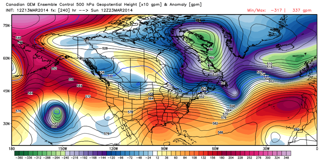
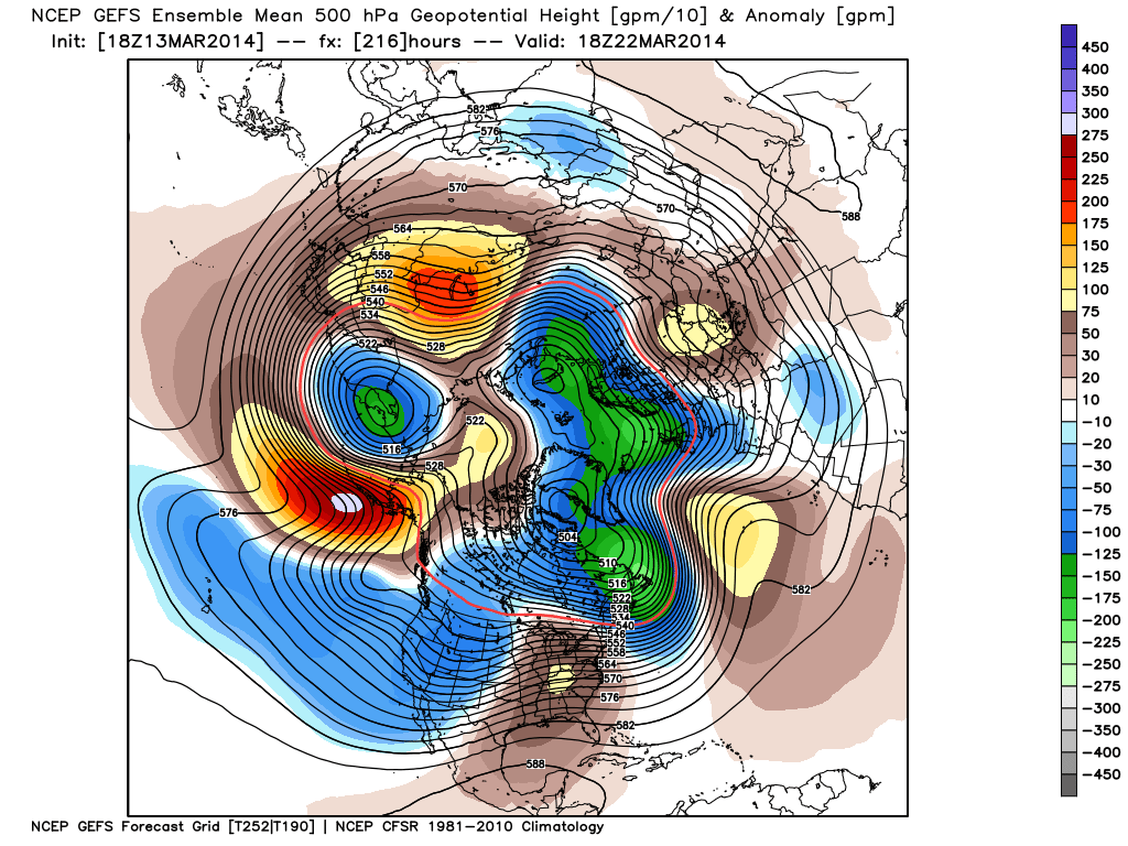
While we remain in a overall colder than normal pattern, spring, obviously, has to get here one day, right?!  The past week has seen an increase in spring at least “flirting” with the region for brief 24-36 hour time periods and this will continue over the upcoming week.

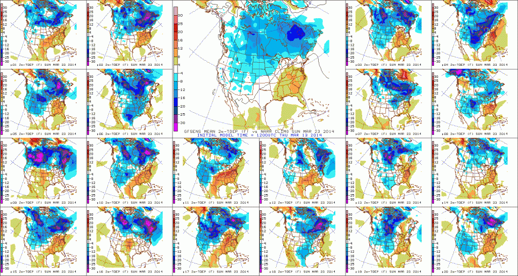
We remain concerned about a potential shot of well below normal cold to open April, but we thought it would be nice to talk about something pleasant for a change.  🙂  We’re keeping a close eye on next weekend, March 22nd and 23rd, for the potential first 70 degree + type day at IND this year.

The latest ensembles aren’t shying away from a significant, though transient, ridge building in during this time period.

12

Note the GFS showing the transient, though significantly, warmer than normal air that would likely occur in this type pattern.  70 degrees + would certainly be attainable.

3

See, we don’t just provide doom and gloom (though this past winter may seem that way) at IndyWx.com!

Permanent link to this article: https://indywx.com/70-degree-type-weather-coming/

A Look At Friday And A Comment On Sunday…

Good evening.  We wanted to touch base on a couple of things this evening.  Details are in the video…

You must be logged in to view this content. Click Here to become a member of IndyWX.com for full access.  Already a member of IndyWx.com All-Access?  Log-in here.

Permanent link to this article: https://indywx.com/a-look-at-friday-and-a-comment-on-sunday/

More Active Changes In Store…

Thr.

Fri.

Sat.

Sun.

Mon.

Tue.

Wed.

 Status-weather-clouds-icon

 Status-weather-clouds-icon

 Status-weather-showers-day-icon

 Status-weather-snow-scattered-day-icon

 Status-weather-clouds-icon

 Status-weather-showers-scattered-icon

 Status-weather-snow-scattered-day-icon

13/ 39

32/ 60

33/ 51

27/ 38

21/ 38

30/ 40

19/ 35

– – –

– – –

Light

Light

– – –

Light

Light

Forecast Updated 03.13.14 @ 7:39a

Thankful For That March Sun…It’ll be a frigid start to your Thursday with many reports of lower teens across the region, including wind chill values around zero.  That said, that strong March sun angle will help temperatures zoom to near 40 with a mostly sunny sky Thursday afternoon.

We’ll do even better than that on Friday, once again with a mostly sunny sky.  We’ll introduce a strong southwest wind into the mix Friday, but this will be a warmer breeze so we’ll take the trade off, right?!  Needless to say, we’ll wrap up the work week with beautiful conditions!

Colder Weekend; Watching A Southern Storm…After another mostly pleasant Saturday, a cold front will blow through here Saturday afternoon.  At the same time, we’ll keep our eyes on a developing wet southern storm system.  Latest guidance keeps this storm south of our region, but we’ll keep an eye on things.  A light shower is possible Saturday morning.  Colder air will blow into town Saturday night and Sunday.

Headaches Next Week…Model solutions vary wildly for next week.  Case in point, the Wednesday afternoon run off the powerful European forecast model suggests a snow storm and cold conditions Tuesday into early Wednesday.  All the while, the GFS takes the storm along the Canadian border and results in a much warmer and drier solution here with highs near 60.  We’re leaning more towards the European in this situation, but not fully buying in just yet to the locked and loaded snow storm solution.

It’s important to note the GFS operational run doesn’t agree with it’s own ensembles so this is one of the main drivers with us at least “leaning” more towards the European solution at this juncture.  We’ll make sure that we keep a close eye on the Tuesday-Wednesday period and update accordingly.  For now we’re going with a rain-to-snow situation Tuesday with potentially accumulating snow falling Tuesday night into early Wednesday.

* This morning we note the European is onto a warmer solution, as well, but before we change our forecast all over the place, we prefer to look over afternoon data and will update things accordingly later this evening for next week.

Upcoming 7-Day Precipitation Forecast:

  • 7-Day Snowfall Forecast: 1-3″
  • 7-Day Rainfall Forecast: 0.25″

twic

For weather updates and more “behind the scenes” data on the go, be sure to Follow Us on Twitter @indywx or become a Friend of IndyWx.com on Facebook!

images

Permanent link to this article: https://indywx.com/more-active-changes-in-store/

Catching Up After A Day Outside Enjoying This Weather…

1.) We don’t really have any changes to the going snowfall accumulation forecast we have out concerning Wednesday.  We think Indianapolis accumulates 2″, with heavier amounts north of the city…

You must be logged in to view this content. Click Here to become a member of IndyWX.com for full access.  Already a member of IndyWx.com All-Access?  Log-in here.

Permanent link to this article: https://indywx.com/catching-up-after-a-day-outside-enjoying-this-weather/