Category: ClientBrief

Client Brief: Severe Weather Event And Flash Flood Potential…

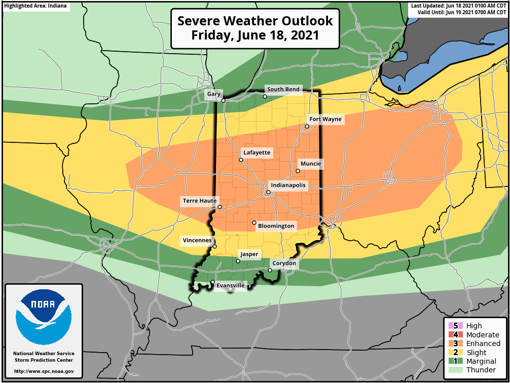
Updated 06.18.21 @ 5:37p

Type: Severe weather event

What: Severe weather event and flash flood threat

When: This afternoon through tonight

Severe Risks: Damaging wind, large hail, embedded tornado potential, flash flooding

Summary: A complex of thunderstorms to our north this morning will diminish. As a result, the cloud canopy engulfing much of the region this morning will give way to mostly sunny skies late morning and into the afternoon. Intense heat is expected this afternoon, courtesy of a southerly flow ahead of an approaching warm front and upper air disturbance. Highs will reach the lower to middle 90s this afternoon and heat indices will climb to between 100° and 105°. This heat, combined with a multitude of other ingredients: dew points into the 70s, convective available potential energy (CAPE) in excess of 4000 j/kg (suggestive of extreme instability), and steep low level lapse rates (rate of temperature change with height) all will play into what looks like a significant setup for a severe weather outbreak later this afternoon and tonight.

Initially, individual cells are likely to erupt (targeting mid to late afternoon) along an OFB (outflow boundary) across n-central Indiana. Damaging wind and large hail are the biggest concerns with these cells, but a tornado threat is also on the table in this highly unstable environment. Eventually the scattered, intense cells should congeal into more of a widespread storm complex by evening and impact most of central and southern parts of the state. Precipitable water values will be in excess of 2” and promote a flash flood risk, especially if thunderstorms back-build and train over the same communities. Should this be the case, localized rainfall amounts of 3”-4” will be a good bet. As we progress into the overnight hours, the storm complex and associated flood risk will shift downstate.

Confidence: HighN

Permanent link to this article: https://indywx.com/client-brief-severe-weather-event-and-flash-flood-potential/

Client Brief: Snow Builds In Overnight – Predawn Thursday…

Updated: 02.17.21 @ 4:54p

Type: Impactful Wintry Weather

What: Accumulating snow

When: 2a to 9p Thursday

Temperatures: 18° to 24°

Wind: N 10-20 MPH, shifting to the NW Thursday night

Blowing/ Drifting: Considerable  

Pavement Impacts: Plowing and salting will be required

Summary: Another round of snow will lift northeast into central Indiana during the overnight and predawn hours (likely arrives into Indianapolis between 1a and 2a). As like so many of these events in the past, this will be another cold storm, meaning we’re looking at another high ratio (15-20:1) event. The dry, powdery nature of the snow will be blown and drifted around by north to northwest winds of 10-20 MPH through the day. While heaviest snow bands should remain across southern and southeastern Indiana, I still expect the rather persistent nature of the snow tomorrow to add up to the tune of 1″ to 3″ for Indianapolis and surrounding areas. Travel will be impacted, including both the morning and evening rush hour. Eventually the snow will depart from southwest to northeast after dark, exiting Indianapolis by around 8p to 9p.

Skies will slowly clear up on Friday and lead to a dangerously cold night (similar to what we saw this morning) and Saturday morning.

Confidence: High

Next Update: Thursday morning

Permanent link to this article: https://indywx.com/client-brief-snow-builds-in-overnight-predawn-thursday/

Client Brief: Periods Of Blizzard Conditions Tonight…

Updated 02.15.21 @ 1:18p

Type: Severe Winter Weather

What: Heavy snow & strong winds

When: Through Tuesday morning

Temperatures: Mid 10s, falling into the upper single digits by Tuesday morning

Wind: NE 15 – 25 MPH (gusts up to 35 MPH Monday evening)

Blowing/ Drifting: Severe  

Pavement Impacts: Plowing and salting will be required

Summary: A shield of snow will encompass all of central Indiana through the afternoon and into the late evening hours. Snow will become heavy at times by mid and late afternoon, continuing through the evening hours, including snowfall rates of 1″ to 2″ per hour. As the area of low pressure draws closer this evening, northeast winds will strengthen and gust up to 35 MPH. Periods of whiteout conditions can be expected around, or just after sunset. Falling snow will end from south to north by midnight to 2a. Strong and gusty northerly winds will continue into Tuesday morning leading to severe blowing and drifting, especially in the open country. In these areas, drifts of 3 to 4 feet are expected.

Confidence: High

Next Update: This afternoon (video)

Permanent link to this article: https://indywx.com/client-brief-periods-of-blizzard-conditions-tonight/

Client Brief: Snow Builds In Overnight; Becomes Heavy Monday Afternoon Into Monday Night…

Updated 02.14.21 @ 12:29p

Type: Severe Wintry Weather

What: Heavy snow & strong winds

When: Monday morning – Tuesday morning

Temperatures: 16° to 21°

Wind: NE 15 – 25 MPH (gusts up to 35 MPH Monday evening)

Blowing/ Drifting: Severe  

Pavement Impacts: Plowing and salting will be required

Summary: Light snow will overspread central Indiana during the overnight, continuing through Monday morning. As the surface low moves northeast (up the Appalachian chain), snowfall rates will increase Monday afternoon into Monday night, becoming heavy at times. The cold nature of this storm system will lead to an efficient snow producer, including rates that will likely top 1″ per hour at times Monday afternoon into Monday evening. As the low moves closer, the pressure gradient will tighten and lead to strengthening northeast wind gusts (up to 35 MPH) for a period of time after sunset into the late evening hours. Travel is highly discouraged tomorrow, especially by afternoon and evening as the combination of heavy snow and strong winds will likely lead to some roadways becoming impassable. Drifts in the open country will likely reach 3 to 4 feet by Tuesday morning. Snow will end from southwest to northeast Tuesday morning.

*Our other products issued later tonight will handle the expected additional significant impacts with Storm #2.

Confidence: High

Next Update: Tonight (video)

Permanent link to this article: https://indywx.com/client-brief-snow-builds-in-overnight-becomes-heavy-monday-afternoon-into-monday-night/

Client Brief: Another Round Of Accumulating Snow On Deck; Blowing & Drifting Also To Be Dealt With…

Updated 02.09.21 @ 7:15p

Type: Impactful Wintry Weather

What: Accumulating snow

When: Late Wednesday morning through Thursday afternoon

Temperatures: 18° to 24°

Wind: NE 10 – 20 MPH and gusty

Blowing/ Drifting: Considerable  

Pavement Impacts: Plowing and salting will be required

Summary: Wednesday will dawn with quiet conditions in place but snow will arrive into central Indiana by late morning. Initially, we’re only talking about light snow into the afternoon and evening. Snow will become more widespread and heavier throughout the “heart” of central IN during the overnight hours and Thursday morning before eventually giving way to lighter snow Thursday afternoon, eventually ending from west to east. Downstate, a mix of freezing rain, sleet, and brief snow is expected, including icy travel. Once again, this will be an efficient snow producer. Instead of snow ratios of 10:1 we expect closer to 15 to 20:1 ratios (similar to that of what southern parts of the state experienced Monday). The dry, powdery nature of the snow will combine with gusty northeast winds to create blowing and drifting issues by Wednesday evening through Thursday, especially in the open country. Gusty winds will persist Thursday night even as the snow comes to an end, extending the blowing and drifting concerns.

Confidence: High

Next Update: Wednesday morning (video)

Permanent link to this article: https://indywx.com/client-brief-another-round-of-accumulating-snow-on-deck-blowing-drifting-also-to-be-dealt-with/