Rain Returns; Wet Snow Accumulation For Some Sunday Morning…

Saturday will once again dawn on a gloomy note, with cloudy skies, areas of dense fog, and drizzle, but we’re not looking at measurable rainfall across central Indiana until we…

You must be logged in to view this content. Click Here to become a member of IndyWX.com for full access.  Already a member of IndyWx.com All-Access?  Log-in here.

Client Brief: Rain To Snow? Yes, But Bigger Deal Damaging Wind Potential And Bitter Cold…

Updated 01.10.24 @ 5:33p

Type: Severe Winter Weather

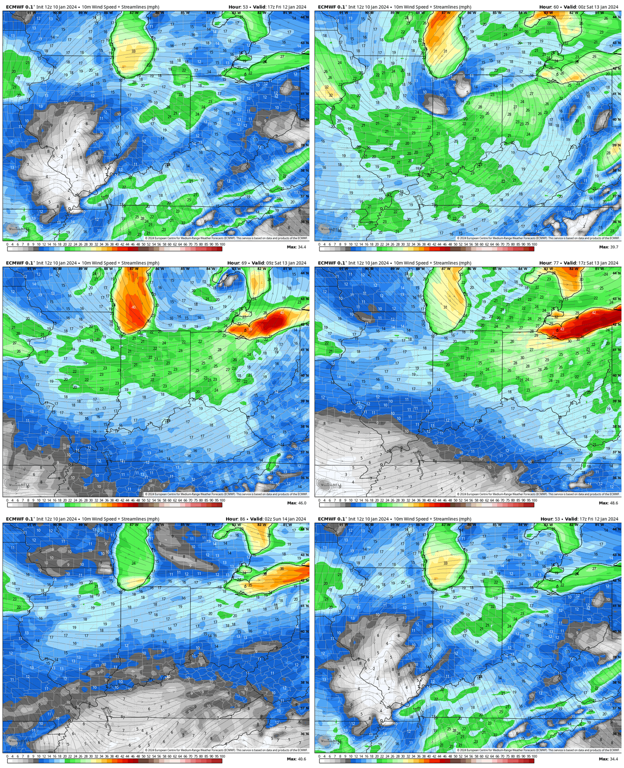
A prolonged period of strong, gusty, and potentially damaging winds will develop Friday into Saturday.
Expected maximum wind gusts

What: Rain changing to snow; prolonged period of strong winds, and bitter cold

When: Friday, 1/12/24 and Saturday, 1/13/24

Wind: Variable 20-30 MPH with gusts to 50 MPH

Temperatures: Middle 40s Friday falling below freezing Friday night and below zero by Sunday morning.

Pavement Impacts: Salting will be required Friday night through the weekend.

Summary: A rapidly deepening area of low pressure will track through central Indiana Friday. What will likely be a SLP in the low 990s (millibars) Friday morning is liable to be in the low 970mb range by Friday night in southern Michigan. This will undoubtedly lead to a “big blow” across all of the region as we close out the work week and head into the weekend and that’s where we want to start with the headlines. A prolonged period of 20-30 MPH winds with gusts close to 50 MPH can be expected during this time frame.

As far as precipitation goes, rain is forecast to move into central Indiana Friday morning, falling heavy at times. If you have travel plans up north across northern Indiana, more in the way of wet snow is forecast during this time period. We’re not expecting to transition to snow until after sunset Friday (from west to east) as colder air pours in on the backside of the strengthening low. Snow showers will continue to fall into Saturday morning and with the strong and gusty northwest winds in place, lowered visibility and some slick spots can be expected across the region. Only light snow amounts are forecast, locally, to the tune of 0.50″ to 1.50″, but good luck measuring that in all of the wind. Scattered snow showers (arctic haze) will continue into Sunday as brutal arctic air oozes into the region.

Confidence: High

Next update: 7:30a Thr

Client Brief: Thursday Evening Update…

Updated 03.02.23 @ 11:03p

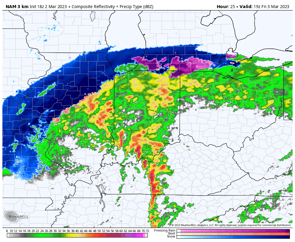
Type: Flooding and Severe Weather; North-Central IN Wet Snow

What: Heavy rain and severe weather; north-central Indiana heavy wet snow

When: Friday, 3/3/23

Wind: Variable 20-30 MPH with gusts to 50 MPH

Summary: A deepening area of low pressure will track into the central Ohio Valley as we close the work week. This will lead to an expanding area of heavy precipitation through the overnight and into Friday morning. Precipitation will fall in the form of heavy rain across central portions of the region, including the Indianapolis area, along with a flood threat. Further north, heavy wet snow will develop across northern IN, into the greater CHI area and into central MI. Note: Early 00z guidance is shifting this area of low pressure further southeast which puts more of north-central parts of the state in play for wet snow accumulation Friday afternoon. We’ll continue to monitor overnight trends but the possibility is there that the rain-snow line will have to shift south compared to what most of the data has been showing the past couple of days. Widespread rainfall amounts of 2”+ can be expected into central IN along with non-thunderstorm gusts of 50+ MPH.

We bracket the 1p to 4p window for the threat of severe storms. This risk lies from Indianapolis proper and points south. We anticipate a line of storms to “bow” out, leading to an elevated damaging wind threat across southern IN during this time period but we also note the potential of a couple of quick spin-up tornadoes within this line of storms, as well. It’ll be important to have a means of getting any and all warnings Friday. Keep tuned to local media or have a way to receive the latest National Weather Service updates. All of the “action,” including the heavy rain threat is expected to wind down Friday evening, including much calmer and quieter conditions returning Friday night.

We’ll be back with a fresh video discussion no later than 7:30a Friday.

Client Brief: Heavy Snow Storm Rolls Into Town Overnight…

Updated 01.24.23 @ 6p

Type: Winter Storm

What: Heavy snow and gusty winds

When: Overnight tonight through Wednesday afternoon

Temperatures: Lower 30s

Wind: E 10 to 20 MPH with gusts of 30 MPH across southeastern IN. Shifting to the north Wednesday PM.

Blowing/ Drifting: Minimal due to the wet nature of the snow

Pavement Impacts: Plowing and salting will be required throughout the region.

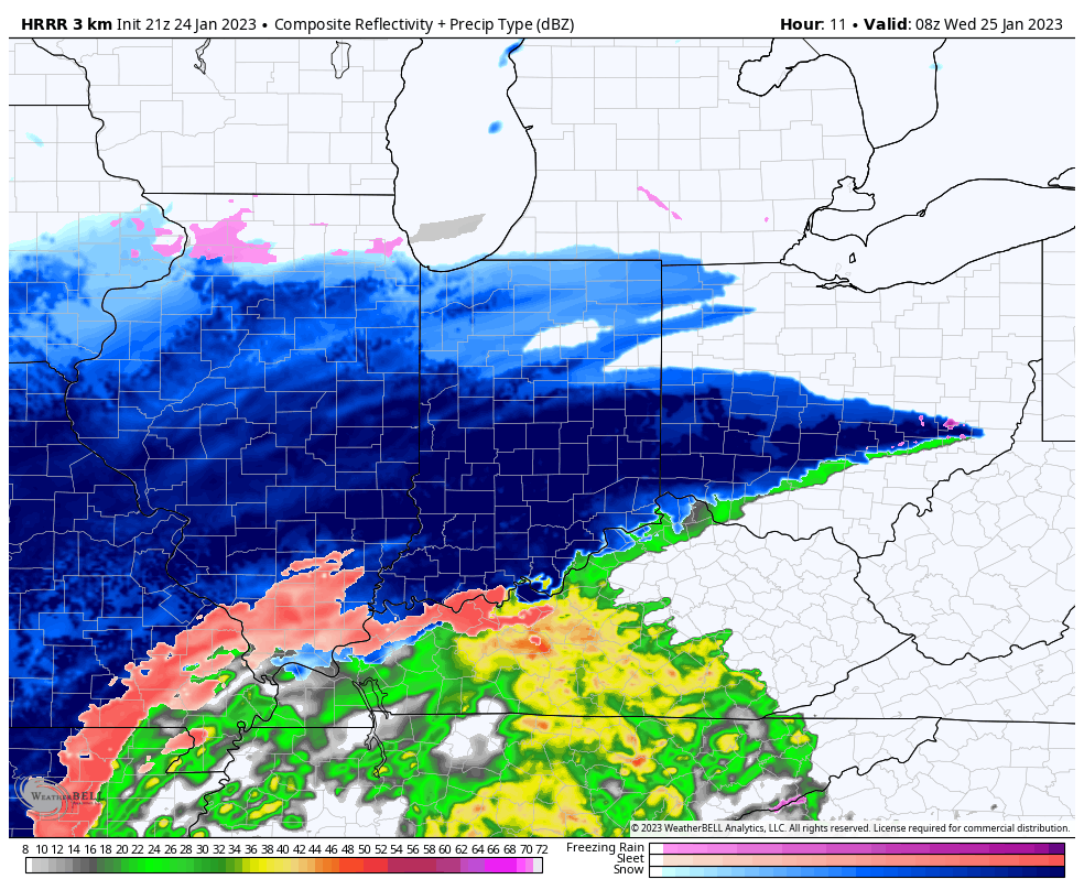
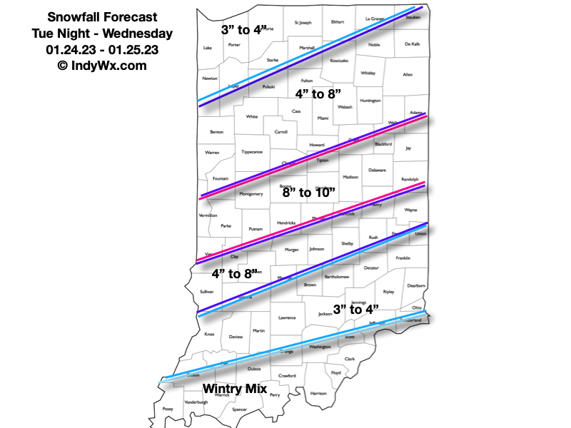
Summary: Central Indiana remains on deck for a heavy snow storm that will begin late tonight across southern IN, reaching the city itself, between 1a and 2a. Snow will quickly become heavy at times, including rates of over 1″ per hour. Needless to say, area roadways, including primary roads, will quickly become snow covered. Latest guidance is also suggesting embedded convective snow bands (thunder snow is not out of the question) will pivot into the city and surrounding areas, especially just west and north, mid and late morning. This “deformation band” will likely lead to jackpot totals approaching double-digits, and we’ve beefed our snowfall forecast up to account for these bands. “System” snow will end from southwest to northeast as we progress through the afternoon. We’ll then await on upper level energy to deliver additional light to moderate snow at times Thursday (additional light accumulation can be expected). Buckle up, there’s additional winter weather to follow…

Confidence: High

Next Update: 7:30a Wed.

Client Brief: Use This Morning To Finalize Prep For Blizzard Conditions And Dangerous Cold Tonight – Christmas Eve…

Updated 12.22.22 @ 7:40a

Type: Severe Winter Weather

What: Heavy snow, blizzard conditions, dangerously cold temperatures

When: Late this afternoon through Christmas Eve

Temperatures: Falling from the upper 30s (Thursday afternoon) to 0° to 10° below zero (Friday morning).

Wind: NW 15-25 MPH, shifting to the WSW and increasing to 25-40 MPH with gusts to 50 MPH

Blowing/ Drifting: Severe

Pavement Impacts: Plowing and salting will be required throughout the region.

Summary: Light rain is overspreading central Indiana this morning as moisture is slowly pulled northward ahead of the approaching arctic cold front. That arctic front is still expected to plow across the state this afternoon (just after lunchtime across western IN, between 3p and 4p for Indianapolis, and by 7p – 8p for our far eastern IN neighbors). Once the front hits, you’ll notice a dramatic wind shift to the northwest and increase to 20-30 MPH with higher gusts, along with a temperature plummet. We’ll likely see temperatures fall more than 20° in less than 90 minutes once the arctic front passes.

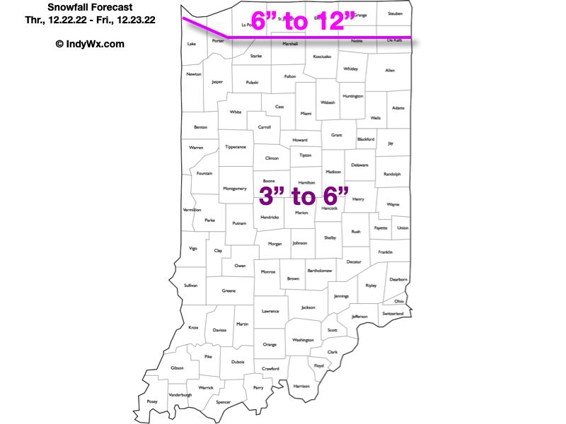
As all of this is taking shape, a wave of low pressure will move from southwest IN late afternoon into eastern MI by Friday morning. Long time Hoosiers know that’s a classic track to deposit a nice snowstorm around these parts. Rain will change to snow in the city around, or just after, 4p and we’ll notice the swath of snow growing in overall coverage and intensity as the low pressure system deepens. Periods of heavy snow can be expected at times tonight.

Meanwhile, winds will continue to increase to 25-35 MPH sustained with gusts to 50 MPH tonight, continuing through the day Friday and into the first portion of Christmas Eve morning. These persistent strong winds won’t only potentially lead to power outages, but continuous blowing and drifting issues through the aforementioned period. Blizzard and whiteout conditions will continue at times. Snow removal efforts will likely have to continue into Christmas Eve to account for the severe blowing and drifting on area roadways, especially north-south roadways. While the heavy snow will come to an end early Friday morning, light snow and blowing snow will persist through the day Friday and into early Christmas Eve morning.

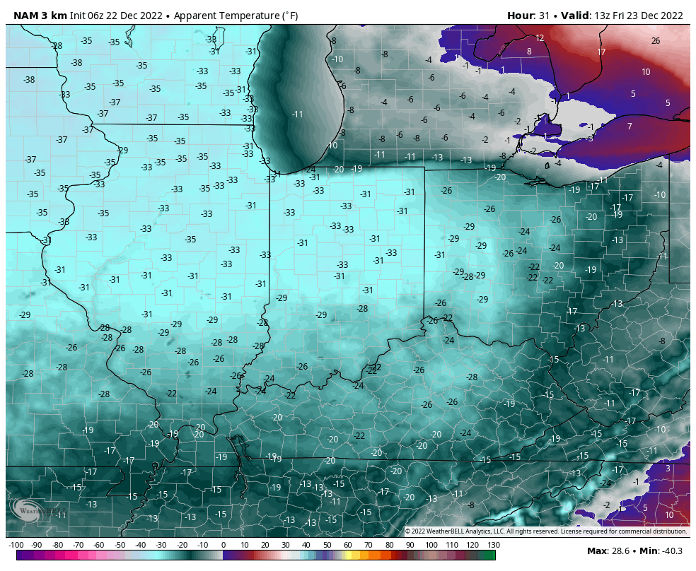
Finally, the dangerous cold is going to be a big problem with this multi-faceted winter storm. After we fall to below zero Friday morning, highs on Friday likely won’t make it back much above 0°. Add in the wind and wind chill values of more than 30° below zero can be expected.

Confidence: High

Next Update: This evening (video discussion)