Category: Christmas/ Thanksgiving

Mild Air On Borrowed Time; Turning Wintry…

Highlights:

  • Dry midweek
  • Rain changes to snow
  • Turning bitter

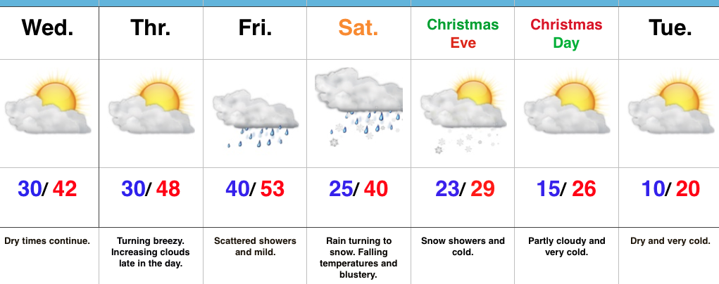
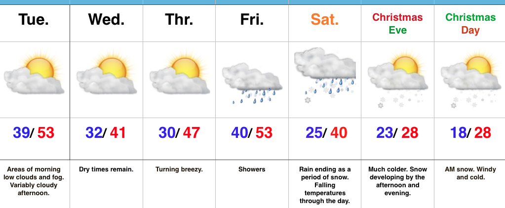
Changes Await…The midweek stretch will feature dry and unseasonably mild conditions.  A storm system will deluge the Tennessee Valley today, but will be too far south to impact our weather.  We’ll shift our air flow around from the northeast today to more of a southerly direction Thursday afternoon.  This is in advance of our next storm system that will deliver showers as we wrap up the last work week before Christmas.

While confidence is beginning to increase in the evolution of things as we head into Christmas weekend, important details are still a bit “iffy” and will require additional fine tuning over the next day, or so.  With that disclaimer, here’s how we see things playing out:

A cold front will slip southeast Friday night and a surface low will move northeast along the boundary Saturday.  The general consensus this morning is that this wave of low pressure will track further southeast when compared to yesterday’s data.  This would yield a colder solution, locally, and subsequent faster changeover to a period of wet snow Saturday.  In fact, if trends continue, we may have to bust out the first snowfall map of the season for Saturday.  Hope for a White Christmas is very much alive and kicking.

MUCH colder air will drill southeast Christmas Eve and with enough upper level energy in place, we forecast an additional period of snow and snow showers Christmas Eve.  Bitterly cold temperatures will take control for Christmas and into early next week.

Upcoming 7-Day Precipitation Forecast:

  • Snowfall: 1″ – 2″
  • Rainfall: 0.25″ – 0.50″

Permanent link to this article: https://indywx.com/mild-air-on-borrowed-time-turning-wintry/

VIDEO: Cooler For Midweek; Discussing Christmas Snow…

You must be logged in to view this content. Click Here to become a member of IndyWX.com for full access.  Already a member of IndyWx.com All-Access?  Log-in here.

Permanent link to this article: https://indywx.com/video-cooler-for-midweek-discussing-christmas-snow/

Mild Now, But The Deep Freeze Awaits; Christmas Snow?

Highlights:

  • Unseasonably mild for now
  • Dry midweek
  • Turning colder and wintry as Christmas approaches

Bottle It Up…By this time next week, most will want to go back in time to the unseasonably pleasant December weather we’re currently experiencing.  If you’re one of these individuals, it’s too bad you just can’t bottle it up for the frigid times that loom.

The short-term period will continue to be dominated by relatively quiet conditions given the time of year.  A storm system will pass to our south Wednesday and provide the Tennessee Valley a good soaking.  We’ll turn cooler for midweek, but remain well above seasonal averages.

A cold front will move towards the region as we wrap up the work week.  This will deliver showers Friday into Saturday before colder air results in a potential transition to wet snow Saturday.  Thereafter, details remain sketchy (at best), but overall confidence is increasing in at least some snow falling during the Christmas Eve – Christmas morning period.

Models are struggling with a second piece of energy that will blow through prior to the big cold blast next week.  Typical model biases are showing themselves this morning (more progressive GFS versus the more amplified European and Canadian).  The best idea at this point is to go with a blend and trend towards a period of snow developing during the afternoon and evening on Christmas Eve, but please understand we’ll have to fine tune things over the next few days.  The other item to consider is that it won’t take much upper energy at all to ring out any available moisture as the arctic intrusion arrives.

Regardless of whether we enjoy Christmas snow or not, the period next week into early parts of 2018 looks particularly cold (at times bitterly so) with additional winter weather opportunities.  Snow removal companies might want to begin stocking up on the coffee!

Upcoming 7-Day Precipitation Forecast:

  • Snowfall: 1″
  • Rainfall:  0.50″ – 0.75″

Permanent link to this article: https://indywx.com/mild-now-but-the-deep-freeze-awaits-christmas-snow/

Arctic Hammer Drops Down Around Christmas…

While the evolution of how things transpire from a snow perspective are “murky,” at best, confidence continues to run very high on the prospects of a nasty period of bitter air arriving around Christmas.

Before we dig into the cold details, the pattern is one that still screams “trouble” from a wintry perspective in the December 23rd-Christmas Eve period.  We posted over the weekend of the PNA-EPO going to battle Christmas weekend, and before the cold overwhelms, a consensus of the data continues to paint an interesting scenario as resistance will be present initially from the southeastern ridge. Modeling will continue to struggle with this evolution over the next few days, but we’re hopeful we’ll begin to gain more clarity by late in the work week.  Needless to say, a stripe of impactful wintry precipitation should fall in a southwest-northeast fashion given the pattern, but whether that’s to our northwest, over our region, or off to our southeast is simply impossible to call from this distance.  A glance at the individual ensemble members (GEFS shown below) shows this nicely, as well.  The European ensemble members also paint a similar picture.

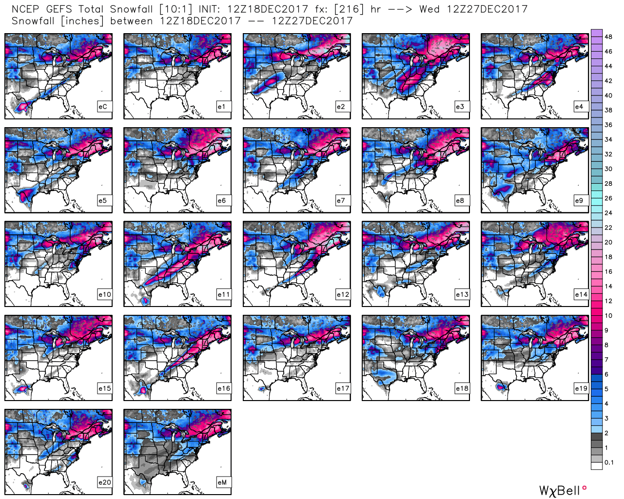
Hang in there as we continue to sort through the data over the next few days.  Once confidence increases (for or against an event), you’ll be the first to know! 🙂

Now to the ugly stuff:  Bitterly cold air of true arctic origin will be dislodged southeast late week and encompass more of the country by Christmas weekend.  Eventually, this arctic air will make it across the Appalachians and reach the East Coast just after Christmas.

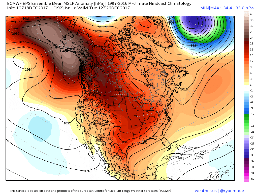
Recent operational data (GFS and Canadian included) has suggested a sprawling high in the range of 1050mb+ descending into the eastern slopes of the northern Rockies.  Such a regime would be plenty capable of spreading sub-zero temperatures east into the Ohio Valley (with or without snow on the ground).  Add in a biting north wind and wind chill values would drop to levels of dangerous and deadly levels if any length of time was spent outdoors.  Some of the latest data paints a picture similar to shades of the famous ’13-14 winter (20° to 30° below zero chill factor).  If you have travel plans over the Christmas holiday, please plan in advance to have a winter survival kit packed and loaded.  It absolutely never hurts to be prepared.

Permanent link to this article: https://indywx.com/arctic-hammer-drops-down-around-christmas/

VIDEO: Gloomy Monday; Colder Pattern Awaits…

You must be logged in to view this content. Click Here to become a member of IndyWX.com for full access.  Already a member of IndyWx.com All-Access?  Log-in here.

Permanent link to this article: https://indywx.com/video-gloomy-monday-colder-pattern-awaits/