Monday Forecast: A Calmer, Colder Week Ahead…

Updated 11.17.13 @ 8:46pm

Zionsville, IN Sunday was a violent day across central Indiana, including multiple tornado touchdowns (Lebanon and Kokomo, for example), heavy rain (widespread 1″+ totals), and damaging straight line winds (numerous trees and power lines down across the region, fueled by 70-80 MPH wind gusts).

Thankfully the new work week will dawn with a much calmer weather pattern in place, albeit much cooler.  High pressure will dominate our region, featuring dry and mostly sunny conditions both Monday and Tuesday.  Monday will still be a bit breezy and we’ll note a stronger push of cold air arriving Monday night, setting the stage for a seasonably chilly Tuesday and Wednesday.

Our next weather maker will arrive as we wrap up the work week. The culprit will be a cold front blowing through the Hoosier state and while model data differs significantly on precipitation totals in the Thursday-Friday time period, we’re confident in rain falling followed by a big blast of cold air for the weekend.

Looking ahead to Thanksgiving week, the threat is there for some wintry “mischief” as southern branch low pressure attempts to attack the cold high to our north… We have plenty of time to watch this, but just make a mental note in the back of your mind for now as you prep for Thanksgiving holiday travel.

Monday: Mostly sunny; 40/ 51

Status-weather-clear-icon


Tuesday: Mostly sunny; 29/ 48

Status-weather-clear-icon


Wednesday: Increasing afternoon cloudiness; 30/ 51

Status-weather-clouds-icon


Thursday: Cloudy and raw with rain likely; 43/ 49

Status-weather-showers-scattered-icon


Friday: Cloudy with rain likely; 44/ 49

Status-weather-showers-scattered-icon


Saturday: Mostly cloudy and colder; 30/ 39

images


Sunday:  Mostly sunny and cold; 19/ 30

Status-weather-clear-icon

Pattern Showing Signs Of More Sustained Wintry Weather?

As we progress into the second half of November and December, friends and family begin to hit the road for holiday travel.  It’s also at this time where winter weather enthusiasts begin to wonder when that first “true winter storm” will arrive.  As we look towards this period, it becomes more important to note the state of the “big three” teleconnections.  These include the PNA (Pacific North America pattern), NAO (North Atlantic Oscillation), and AO (Arctic Oscillation).  While it’s impossible to predict, with 100% certainty, the weather based solely off these teleconnections, they can be very good indicators of where the pattern may be heading in the next couple three weeks.

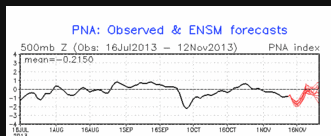
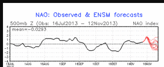
In a “perfect world” for those wanting cold and wintry weather here across the Hoosier state you want to see a positive PNA, which promotes western ridging and eastern troughiness (associated with cold weather).  Additionally, you want to see a negative AO and NAO (promotes high latitude blocking and corresponding cold, arctic, air is shunted south into the Lower 48).  What do the teleconnections currently show?

ao.fcst


pna.fcst


nao.fcst


Taken at face value, this suggests a cold and potentially wintry pattern may ensue to close out November and as we go into December.  We’re looking at an AO and NAO trending negative and a PNA trending positive.  *It should be noted that, at times, a negative NAO can be so strong that it supplies the cold air, but can also lead to a suppressed storm track- south of the available cold air…

Each storm provides it’s own set of challenges and must be dealt with as they come. We can look at past storms and patterns (called analog forecasting) to help get an “idea” as to what patterns and storms in front of us may produce, but no storm is identical to the other.  At this early stage in the game, it appears as if a pattern is setting up that could provide “wintry mischief” just at the time when most folks want it- for the Thanksgiving and Christmas season.

Stay tuned…