The Pending Halloween Pattern Transition And Initial Taste Of Winter…

Updated 10.21.23 @ 7:34a

The upcoming week will feature a pattern shift, albeit a transitional one, that will drive unseasonably warm temperatures north into the Ohio Valley and Great Lakes region. This will be on the heels of the first widespread frost of the season Monday morning. Ah, Indian summer at its finest.

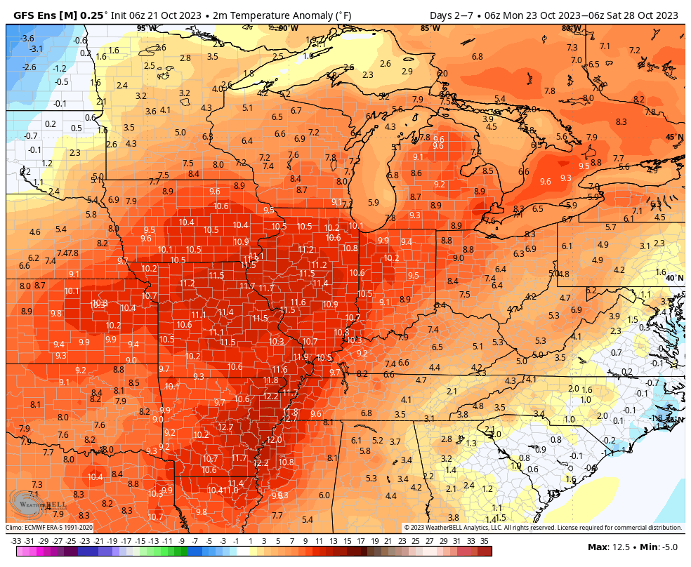
A couple of disturbances will try to make inroads into this ridge mid and late week, but will likely struggle in providing much in the way of precipitation or cooler air initially. As we push into the latter part of next week and the Halloween weekend, a larger storm system is anticipated to move east out of the Plains region. This storm will likely deliver the first widespread winter impacts (outside of the mountains of course) of the fall season.

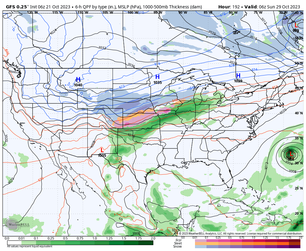
Specifics will be fine tuned as we get closer, but we expect a widespread rain (perhaps a clap of thunder) here next weekend followed by sharply colder weather prior to Halloween, itself.

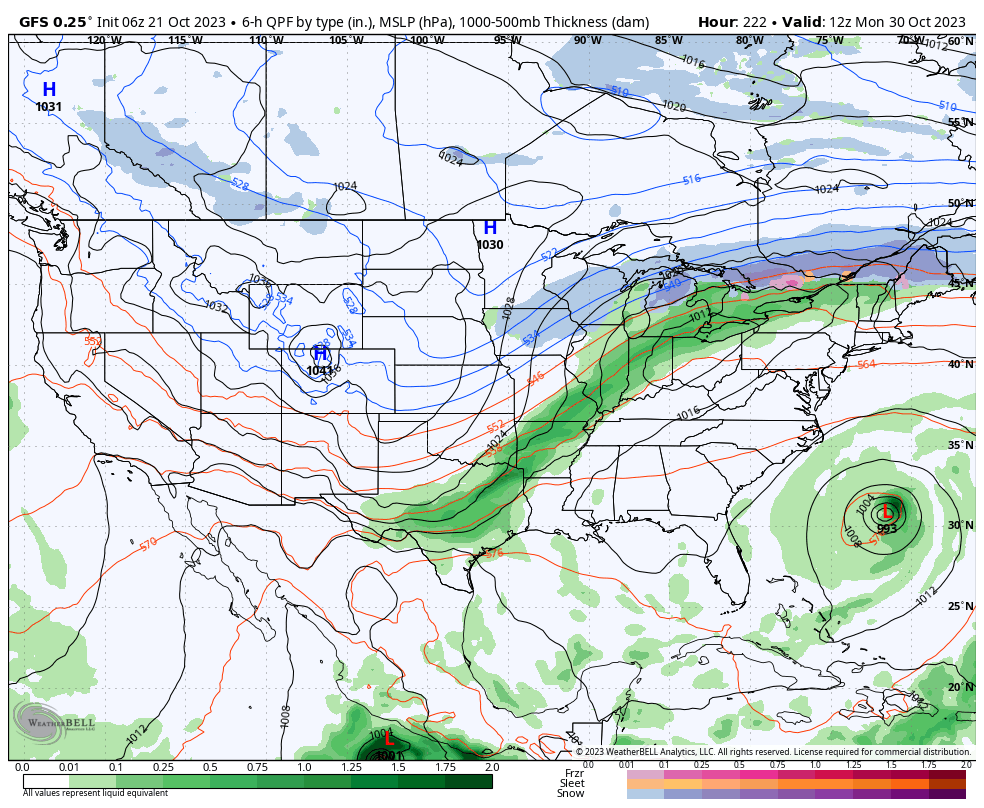
We’re left with a much different pattern to open November. This is the type regime that will likely lead to the first lake effect snow in the snow belt, drive the 1st widespread freeze into the Ohio Valley, and result in highs in the 40s in the wake of the frontal passage.

Farmers and those with ag interests, we’d suggest wrapping up harvest 23 efforts by mid next week if at all possible. Conditions will certainly become harsher and less favorable by next weekend. More to come…

Weekly Severe And #AGwx Outlook…

Updated 06.14.22 @ 7:33a

After getting beaten down this weekend, the upper ridge will flex it’s muscle yet again next week, significantly influencing our pattern.
Widespread above normal temperatures can be expected given the 500mb pattern above from the Plains into the Southeast and up into the Great Lakes.
Widespread drier than normal conditions are anticipated from the Plains, Southeast, and up into the Ohio Valley as the ridge dominates.

Forecast Period: 06.14.22 through 06.24.22

A cold front will slide through the area Thursday with the potential of a widely scattered shower or storm. The bigger story will be a significant reduction of heat and humidity as we close out the work week and head through the weekend. After dealing with heat indices in the 105º+ range today and Wednesday, lows that drop back into the 50s this weekend sure will feel nice. After Thursday, dry conditions should dominate through the weekend.

The upper ridge will then expand northeast once again as we head into the new work week. You know what this means, oppressive heat and humidity will return next week. Like this week, the most oppressive conditions come in the Tuesday-Thursday time frame before another cold front returns us to cooler, more seasonal temperatures next weekend. Get the idea that we’re locked into a “transitional” pattern for the foreseeable future?

From a rainfall perspective, we’re in that time of year where it’s all but impossible to predict rainfall amounts down to a specific backyard (case in point yesterday where many north and eastern Indianapolis ‘burbs clocked in a quick 2″+, while others on the south and west side didn’t see a drop of rain). From an overall perspective, rainfall amounts will run well below normal over the next 7-10 days. We will keep an eye on storm clusters that may round the periphery of the upper ridge early next week, and these could influence our weather Monday into Tuesday (similar to what we dealt with yesterday).

As we look beyond the 10 day period, the ‘mean’ upper pattern should feature the ridge pulling back west and placing our immediate region into a northwesterly flow aloft to close the month of June. This should translate to relatively wetter, cooler times.

10-Day Rainfall Forecast: 0.50″ to 1.00″

Weekly Severe And #AGwx Outlook…

Updated 06.06.22 @ 7:50a

The ‘mean’ upper air pattern will continue to favor a trough and northwest flow aloft across our general region through the upcoming 7-10 days.
While heat bakes across the Southwest and southern Plains, the theme, locally, will continue to be a refreshing one for June standards.
Precipitation is forecast to run slightly above normal for the 10 day period across the Great Lakes, Ohio / TNValley region, and Northeast.

Forecast Period: 06.06.22 through 06.16.22

After a calm open to our Monday, a storm system will blow in from the west and lead to an expanding area of storms this afternoon into the evening. From the area in and around Indianapolis and points south, some of these storms could become strong to severe (large hail and damaging winds being of greatest concern). Localized flash flooding is also possible due to the training nature some cells may take. Unfortunately, a rough evening commute is a good bet due to the timing of this storm complex.

After a quiet Tuesday, a similar setup can be expected of that from today on Wednesday. We’ll time the afternoon and evening hours for the arrival of the unsettled, stormy conditions. Additional chances of strong to severe storms will be likely, including threats that are similar to today.

Finally, another system will deliver a round of showers and storms Friday. The good news is that for the 3rd consecutive weekend, it appears as if the area will enjoy pleasant weather, including unseasonably cool, refreshing temperatures.

As we flip the page to next week, the week will open with a similar pattern dominating (northwesterly flow aloft) that will have to be monitored for the likelihood of additional storm clusters. Thereafter, models are in a bit of a disagreement on what takes place with building heat to our west. It’s possible this hot dome nudges far enough east to heat us up the middle of next week. With that said, indications are that even if this is the case, we wouldn’t see prolonged hot, humid times that our friends across the southern Plains and Southwest are contending with.

10-Day Rainfall Forecast: 1.5” to 2” (localized heavier amounts in excess of 2” will be likely where storms train).

Notes and Asides: Have been on the road the past few days. Travel day tomorrow but will be back at home base by evening. As such, please expect a delay in tomorrow’s post. We’ll have a client video posted towards late afternoon.

Weekly #AGwx And Severe Weather Outlook: Tracking 2 Cold Fronts This Week…

Updated 05.30.22 @ 8a

With the official “unofficial” 🙂 start to summer upon us, it’s time we start to once again produce our weekly #AGwx reports. Each week, these updates will focus on the overall temperature and precipitation pattern over the upcoming 7-10 days, along with bigger severe weather or tropical items of note when needed.

The upcoming 10 days will continue to feature a very transient pattern, locally.
Overall, temperatures will average close to seasonal norms when all totaled up over the upcoming 10 days, but the way in which we get to this point will feature plenty of “ups and downs,” relative to average.
Precipitation will run very close or just slightly below normal values during the time period.

Forecast Period: 05.30.22 through 06.09.22

Our weather pattern will start off very quiet as high pressure continues to dominate. We’ll notice a bump in humidity values daily leading up to a frontal passage Wednesday night and early Thursday morning. This front will deliver scattered to numerous showers and thunderstorms across the Mid West and Ohio Valley Wednesday. While there could be a couple of stronger storms, the severe aspect of this system is expected to be greatly diminished when compared to what our neighbors in the northern Plains and upper Mid West will see over the next couple of days.

The frontal system will pass through rather quickly and we’ll get back to a much less humid, cooler airmass Thursday, continuing into the first half of the weekend. That’s when we’ll begin to track system #2 with eyes on our immediate area Sunday. Widespread showers and thunderstorms are expected for the 2nd half of the weekend, but it won’t rain the entire time. This will likely set the stage for a more active period to close out the 10 day as a persistent southwesterly air flow dominates.

10-day Rainfall Forecast: 1.5″ to 2.5″