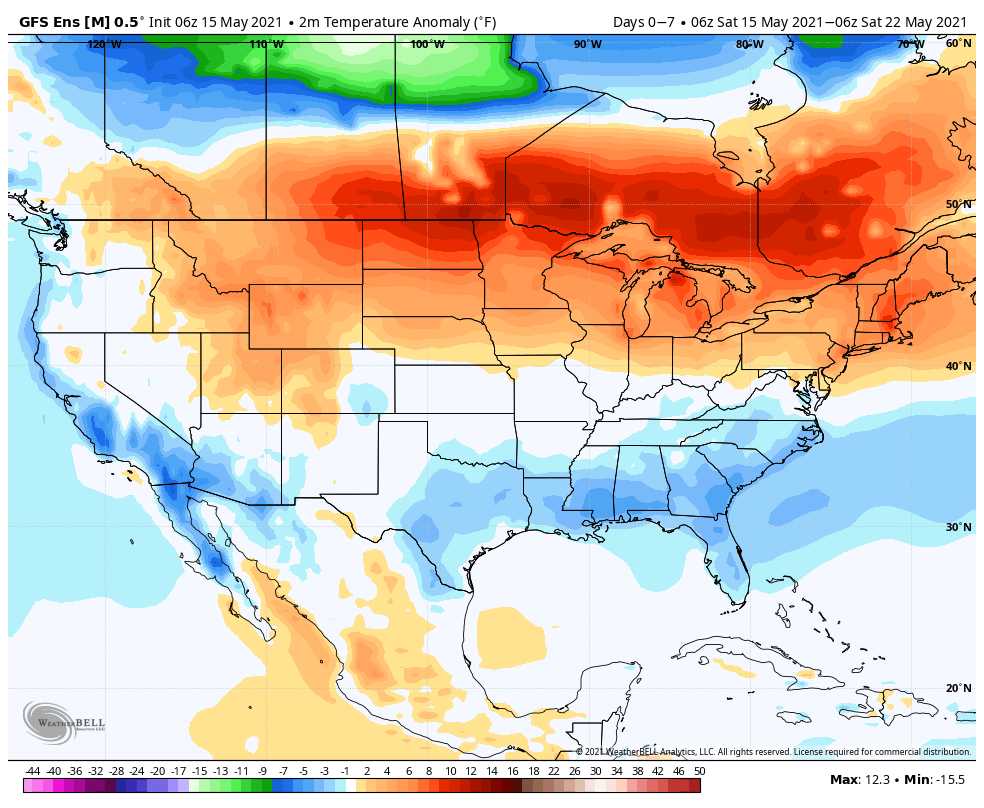
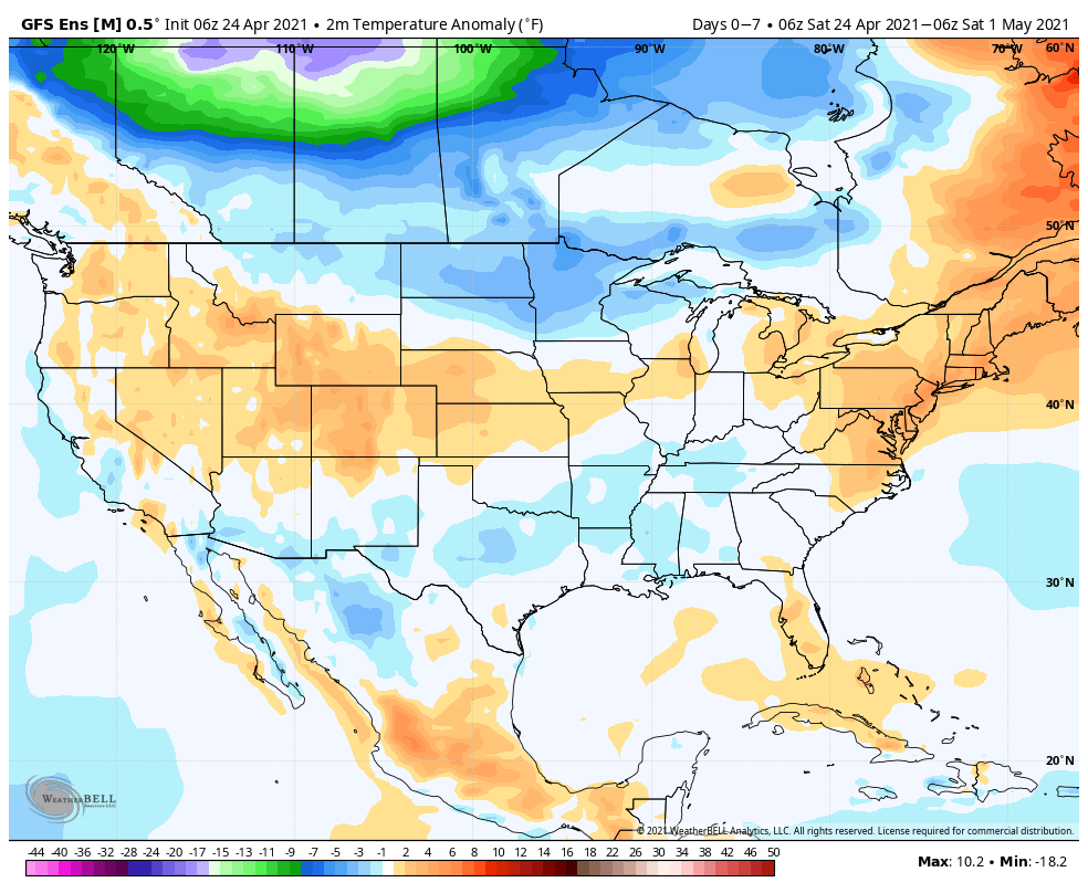
Temperatures will run slightly above normal (for a change) across a good chunk of the country through the upcoming 7 days. Only exception to this will be across the South.
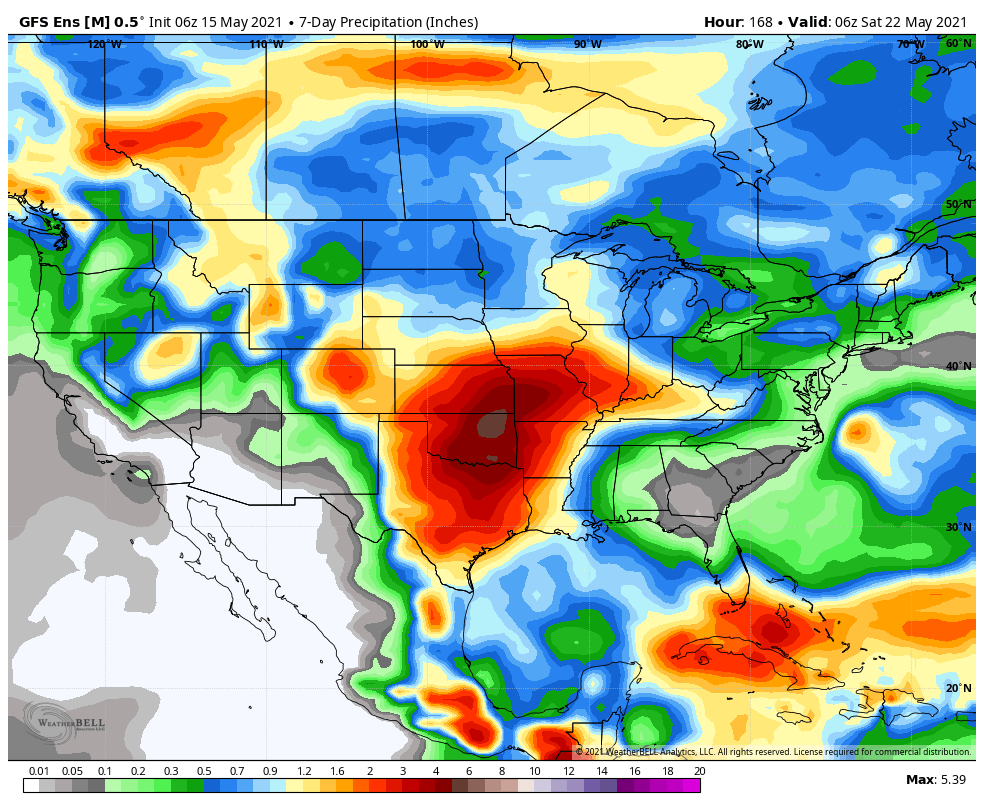
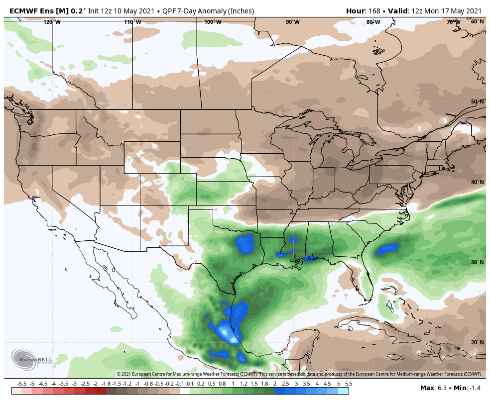
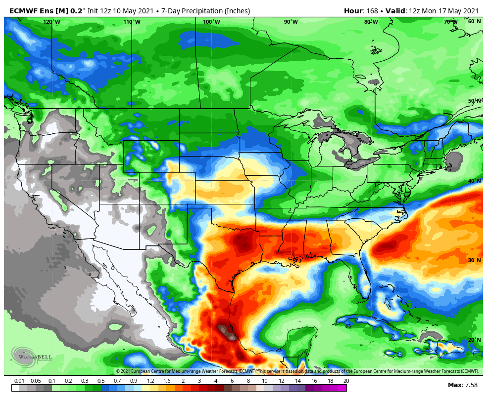
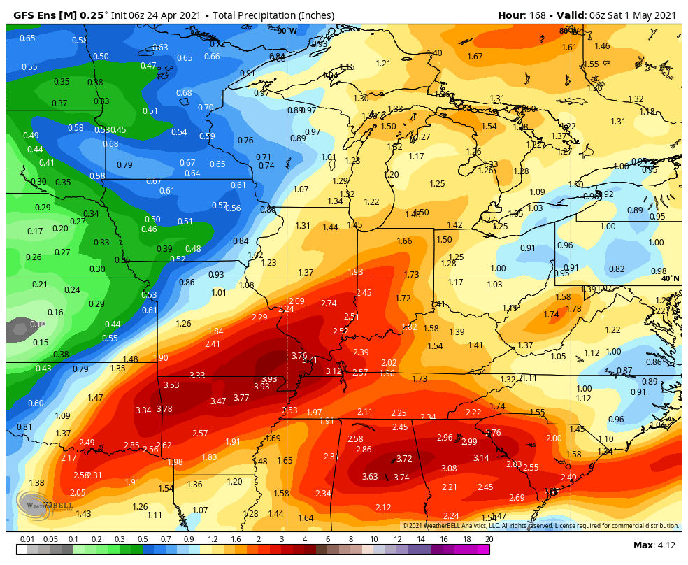
The Heartland will be in the cross hairs of a multi day heavy rain event this week. Meanwhile, from the central and Ohio Valley and points east we’re looking at a continued dry stretch.
Central Indiana can expect between 1” and 1.5” of rain in the week ahead on average.
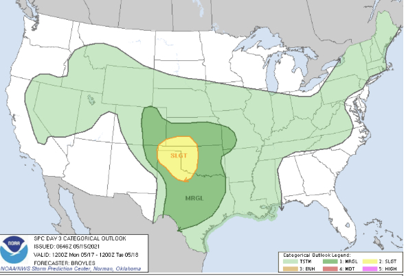
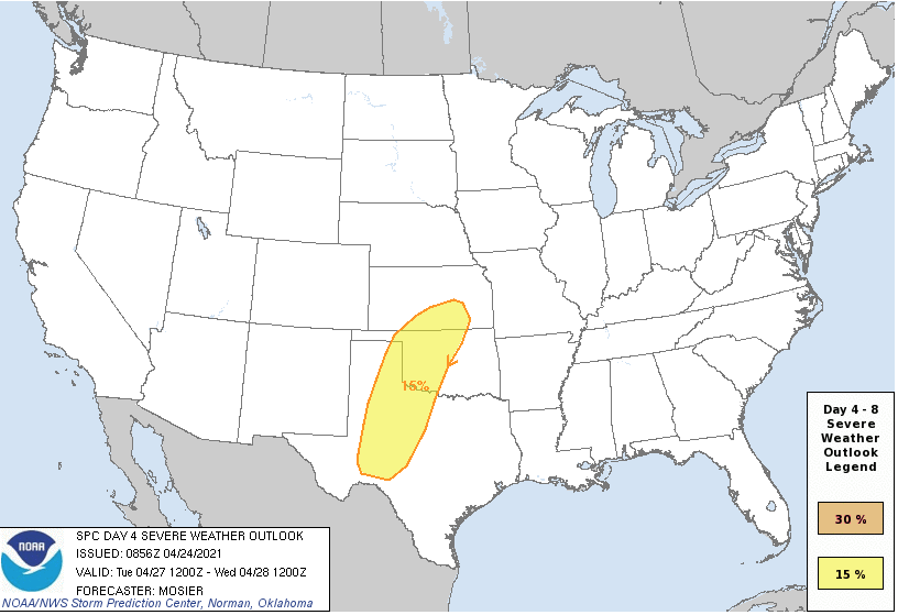
This will be an active week for the Plains as a multi day severe weather episode compliments what will also be an evolving flood risk.
Forecast Period: 05.15.21 through 05.22.21
Change is ahead over the upcoming week towards a pattern more typical of what we’d come to expect this time of year. We’ll say goodbye to the cool, crisp air in the short term period and replace it with an increasingly warm and muggy feel of things. Scattered showers and thunderstorms will accompany this transition. While the chances of widespread heavy rain are diminishing, we will see scattered to numerous showers and storms during the early and middle part of the work week. These will be of the “splash and dash” variety and certainly won’t require any cancellation of outdoor plans. High pressure appears like it’ll nudge its way into the region Wednesday night, allowing us to enjoy another stretch of dry conditions as we close the work week and head into next weekend.
Temperatures will continue to run well below normal, overall, through the upcoming 7-day period.
While above normal rainfall is expected along the Gulf Coast, most of the country will enjoy quiet and drier conditions through the upcoming period.
We forecast 0.25″ to 0.50″ over the upcoming 7-day period for central Indiana. Most of that falls today or next Monday.
Forecast Period: 05.10.21 through 05.17.21
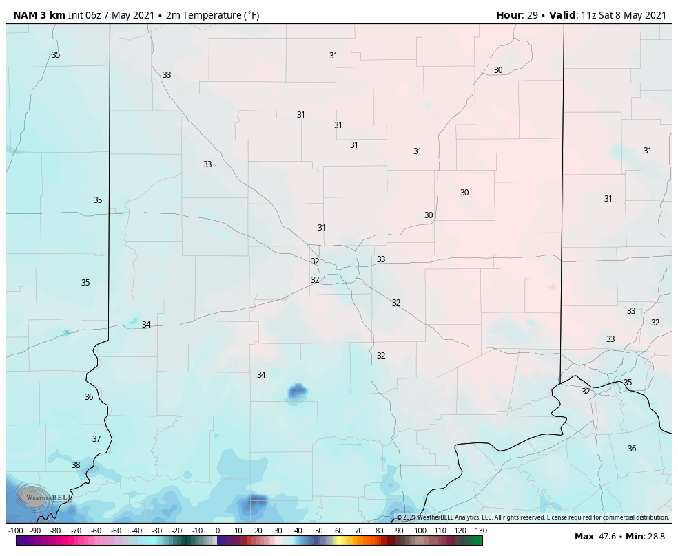
The upcoming forecast period will be met with unseasonably cool and dry conditions. While we have some showers to track this evening (mostly from Indianapolis and points north), the large majority of the rest of the period above will feature an extended period to dry out with considerable amounts of sunshine. The downside? Clear skies and calm winds at night with a late season arctic high dominating will result in a couple of additional frosty nights ahead. The coldest mornings appear dialed up Wednesday and Thursday. Mid 30s will be common with a few reports of low temperatures around freezing for outlying communities. The next opportunity for rain won’t arrive until Sunday afternoon/ evening. With high pressure dominating, severe weather isn’t expected, locally, and will remain below normal for the rest of the country.
Many find themselves waking up to the upper 30s this morning.
While certainly chilly by May standards, we’ll be even colder tomorrow morning. This will come behind a passing upper level disturbance that will likely kick up another round of scattered thunder (some storms may contain small hail) this afternoon and early evening. Lows Saturday morning may rival records in spots. The record low in Indianapolis tomorrow morning is 31° set in 1976 and 1947.
Officially, we’re forecasting a low in Indianapolis of 35° Saturday morning, but others outside of the city will be close to the freezing mark.
We still anticipate a Mother’s Day soaker (rain may begin around sunset Saturday after what should otherwise be a very nice day), including embedded thunder. Rainfall totals with this system will check-in between 1.5″ and 2″ for most, including locally heavier totals above 2″. The axis of heaviest rain is forecast from Indy and points north with the latest American model guidance and central and southern portions of the state from the European guidance. Expect the consensus of modeling to improve on precisely where the heaviest totals setup over the next 24 hours.
The primary purpose of this morning’s post is to look at the chilly start to May and where we think things are headed for the 2nd half of the month.
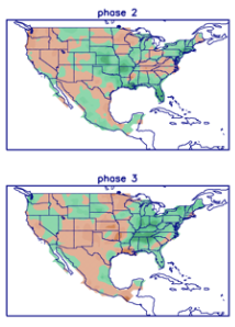
The “revved up” MJO (into the traditionally cold May phases) initially is what tipped us off to the cold open to the month. For those that have been paying attention to the modeling, you could see how the data had to continue correcting colder and colder up until “real term.” Officially, we’re running 1.6° below normal so far, but with the cool in the week ahead, that will grow much more impressive in the days to come.
Temperature departure from normal over the upcoming 7-days.
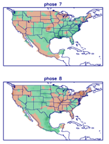
This should come as no surprise with us set to move strongly into Phases 2-3 over the course of the upcoming 7-10 days. Note greatest temperature departures from normal occur across the Ohio Valley in these phases in May.
What’s more interesting is what transpires after this period (mid and late May). The MJO is expected to head into the “null phase” for a time.
One could extrapolate the data and build a case we’re headed for phases 7-8 to close the month. If so, things would moderate (against the norms) by Phase 8.
This is something we’ll watch. If we do, indeed, get into Phase 8 prior to Memorial Day, we’d expect the heat to build to close the month. The transition will likely be less significant though. The thinking here is still relatively cooler than normal mid-month before moderating closer to and/ or slightly above normal prior to Memorial Day.
From a precipitation perspective, the pattern continues to look quite active for the foreseeable future.
You must be logged in to view this content. Click Here to become a member of IndyWX.com for full access. Already a member of IndyWx.com All-Access? Log-in here.
Temperatures will moderate from the unseasonably cold conditions as of late. We’ll make a run for 80° by Tuesday here in central IN.
Above normal rainfall is expected in the week ahead from the mid MS Valley and Gulf Coast into the Ohio Valley and Great Lakes.
We forecast most central IN rain gauges to receive between 1.75″ and 2.25″ in the week ahead.
A new spring storm will emerge out of the Plains Tuesday and likely ignite a round of severe weather throughout tornado alley.
Forecast Period: 04.24.21 through 05.01.21
A relatively weak storm system will lead to plenty of clouds today and a couple of light passing showers (better chance of steadier rain downstate). This system will blow by to our east tonight and allow a drier air mass to build into the region as we move through the 2nd half of the weekend, complete with a return of sunshine! Enjoy the sunny and much warmer open to the week as significant changes await by Wednesday. Before this, a strengthening southwesterly air flow will push high temperatures into the lower 80s Tuesday! Attention will then shift to a complex and multifaceted storm system that will deliver heavy rain and thunderstorms (potential present for a couple stronger storms midweek that we’ll continue to monitor) in rounds Wednesday through Friday. While it won’t rain the entire timeframe, periods of heavier rain can be expected. We’ll dry things back out heading into next weekend.