Category: 7-Day Outlook

Wind And Cool Air The Big Story Here…

Screen Shot 2015-10-01 at 10.22.27 PMHighlights:

  • Clouds and wind increases Friday
  • Windy, chilly, showery Saturday
  • Brighter days ahead with warmer temperatures

Hurricane Joaquin remains at the top of many weather headlines, and rightfully so.  Currently a category 4 hurricane, Joaquin is nearly stationary in the Bahamas this evening and presenting problems on many fronts (storm surge, wind, flooding).  Eventually Joaquin will make a northward turn and begin to pick up momentum Friday night and Saturday.  Today’s model guidance remains firm on the idea Joaquin will remain off shore from the US mainland, but we’ll need to continue to keep a close eye on things.

Here on the home front, the combination of the high to our northeast and upper low across the southeast will really serve to tighten the pressure gradient and result in strong east and northeast winds as we wrap up the work week and head into the weekend.  Gusts of 30-40 MPH will be a good bet.

Clouds will be on the increase Friday with the possibility of PM showers- particularly east and southeast.  It’ll be a cool day, but nothing compared to Saturday.  Expect better coverage of showers Saturday, continued gusty winds, and even cooler air.

Brighter (and warmer) times will begin to return to wrap up the weekend and head into next week.

Upcoming 7-day Rainfall Forecast: 0.10″ (NW) – 0.50″ (SE)

Permanent link to this article: https://indywx.com/2015/10/01/wind-and-cool-air-the-big-story-here/

Times, They Are A Changing…

Screen Shot 2015-09-30 at 7.14.53 AMHighlights:

  • Much cooler and breezy for mid week
  • Windy, chilly, and wet end to the week
  • Drier early next week

A complicated series of events will lead to a memorable week/ weekend of weather along the eastern seaboard.  Between the cold front that moved through here last night, Joaquin (well on it’s way to becoming a hurricane this morning), and energy that moved out of the Gulf of Mexico, the eastern seaboard is in for a major flood event, and long duration wind/ beach erosion event.

Before we discuss potential impacts closer to home, let’s talk the short term.  Showers will continue to push south this morning and a dry, breezy, and cooler day is coming.  Thursday will be breezy and cool, but dry also.

It’s when we get to the weekend that things begin to shift.  We know windy and chilly conditions are a given this weekend (you can take that to the bank).  We caution that much fine tuning will be required as we progress through the next couple days in regards to rainfall.  Here’s our best stab as of this morning.

1.) Showers pinwheel west Friday afternoon and evening as east winds strengthen- gusts 25-30 MPH.

2.) Steadier rains fall Saturday and Sunday with east and northeast winds gusting to 30-40 MPH.

3.) Steady rains diminish and give way to scattered showers Monday before we’re back to dry weather Tuesday.  Winds also begin to diminish during this period, but gusts to 20-30 MPH are still possible Monday out of the north.

Stay tuned, as the rainfall forecast is still up for much debate and will have to be fine tuned.

Upcoming 7-Day Rainfall Forecast: 0.25″ – 0.75″

Permanent link to this article: https://indywx.com/2015/09/30/times-they-are-a-changing/

Rain Today; Windy And Much Cooler Times Ahead…

Screen Shot 2015-09-29 at 7.04.40 AMHighlights:

  • Rainy weather today
  • Much cooler conditions coming
  • Prolonged stretch of strong winds

The region will be under a squeeze play of sorts today as tropical moisture continues to lift north from the Gulf Coast and a cold front approaches from the northwest.  The end result will be for an expanding shield of rain to encompass a large portion of central IN as the day progresses.  Heaviest rainfall is still expected downstate, but there will also be some localized heavier totals across central IN, as well.  This, of course, is much needed.

The cold front will pass tonight and shut off any threat of rain.  The big story will become the much cooler air mass settling into the region for the foreseeable future.  Additionally, factor in the goings on along the eastern seaboard with an area of high pressure building in from the north and very windy conditions can be expected as we move through late week into the weekend.  Strong and gusty northeast winds will be very persistent, with gusts up to 30 MPH at times.

We’ll continue to keep close tabs along the happenings along the eastern seaboard late in the period.  As of now we think high pressure should keep us dry and cool, but stay tuned.

Upcoming 7-Day Rainfall Forecast: 0.50″-1″

Permanent link to this article: https://indywx.com/2015/09/29/rain-today-windy-and-much-cooler-times-ahead/

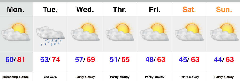
Warm Start To The Week, But Cool Changes Coming…

Screen Shot 2015-09-28 at 8.52.01 AMHighlights:

  • Increasing clouds
  • Shower chances go up tonight
  • Much cooler air coming

The work week has gotten off to a pleasant and dry start with sunshine across central IN.  That said, a quick look at the satellite shows clouds and moisture streaming north.  Expect increasingly cloudy skies as we progress through the second half of the day with showers developing tonight.  The region will be in a “squeeze play” of sorts Tuesday as a cold front from the northwest and tropical moisture from the Gulf of Mexico collide.  The end result will be locally heavy rainfall downstate with numerous showers extending north into central Indiana, as well.

The cold front will sweep through the region Tuesday night and help usher in a much cooler air mass for the rest of the week, continuing into the weekend.  Sweaters and jackets will be needed this weekend.

Upcoming 7-Day Central Indiana Rainfall Forecast: 0.10″ – 0.30″

Permanent link to this article: https://indywx.com/2015/09/28/warm-start-to-the-week-but-cool-changes-coming/

Clouding Up; Saturday Showers Arrive…

Screen Shot 2015-09-24 at 10.23.01 PMHighlights:

  • Clouds increase to wrap up the work week
  • Tropical connection courtesy of the Atlantic this weekend
  • Midweek cold front

An area of low pressure is slowly tracking north along the SC coast Thursday evening.  A surge of tropical moisture will retrograde (that’s for you, Rick ;-)) northwest and result in “showery” weather around these parts to open the weekend.  We’re not talking a lot of rain, but expect periodic wet times for central and southern portions of the state Saturday.  We’ll maintain mention of a shower Sunday, but Sunday will be the drier of the two days.

We’re back to “high and dry” early next week, but a weak frontal boundary will move through here late Wednesday with a broken band of showers.  Not everyone will see rain Wednesday.  Slightly cooler air will arrive late next week.

Upcoming 7-Day Rainfall Forecast: 0.10″ – 0.30″

Permanent link to this article: https://indywx.com/2015/09/24/clouding-up-saturday-showers-arrive/

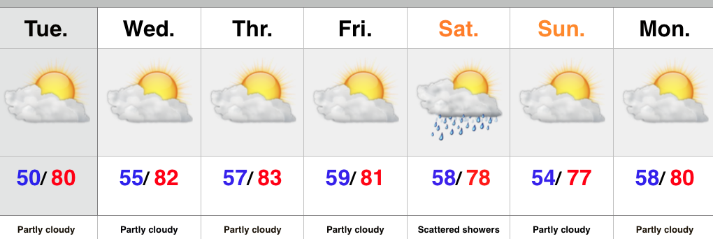
Warm And Mostly Dry Forecast…

Screen Shot 2015-09-21 at 5.27.39 PMHighlights:

  • Dry conditions continues
  • Temperatures warm
  • Weak front Saturday

It’s a very boring forecast as high pressure remains in control through the short-term.  This will continue to promote dry conditions.  Moderating temperatures can also be expected as our air flow backs around to the SW with time.

The only item of significance in this 7-day is a weak frontal boundary that will move through here with scattered showers Saturday.  Slightly cooler air will push in behind the boundary, but it’s an overall very warm pattern.

Upcoming 7-day Rainfall Forecast: 0.10″

Permanent link to this article: https://indywx.com/2015/09/21/warm-and-mostly-dry-forecast/

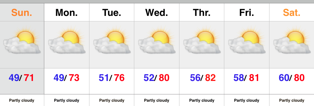
Back To A Dry Pattern…

Screen Shot 2015-09-19 at 9.18.44 PMHighlights:

  • Dry conditions return
  • Moderating temperatures through the week

There’s no reason to waste a bunch of pixels on the forecast ahead.  High pressure is building in behind the cold front that moved through here Saturday morning.  As a result expect dry skies and mostly sunny conditions into next weekend.  The cooler, fall-like, air of the weekend will begin to moderate back to summer-like levels into the latter portion of the upcoming work week.

Upcoming 7-Day Rainfall Forecast: 0.00

Permanent link to this article: https://indywx.com/2015/09/19/back-to-a-dry-pattern/

A Look Where We’ve Been And Where We’re Going…

September to date has been drier and warmer than average across the region- right as planned thus far, overall.       This morning featured a more aggressive push of showers…

You must be logged in to view this content. Click Here to become a member of IndyWX.com for full access.  Already a member of IndyWx.com All-Access?  Log-in here.

Permanent link to this article: https://indywx.com/2015/09/18/a-look-where-weve-been-and-where-were-going/

Cooler After A Few Showers…

Screen Shot 2015-09-17 at 9.31.12 PMHighlights:

  • Scattered showers around
  • Cooler air builds in Saturday
  • Still a dry pattern overall

As we wrap up the work week we notice a cold front off to our west.  This front will move through the region Saturday morning and will be accompanied by a broken band of showers.  More significant showers and thunderstorms will fall across northern IN as that portion of the state will be closer to an area of low pressure.  Across central IN, what once will look like an impressive line of showers and thunderstorms will weaken dramatically moving into the area.  The front will move through Saturday morning with a notable wind shift and cooler air Saturday afternoon/ evening that will remain into early next week.

Upcoming 7-Day Rainfall Forecast: 0.10″ – 0.25″


Permanent link to this article: https://indywx.com/2015/09/17/cooler-after-a-few-showers/

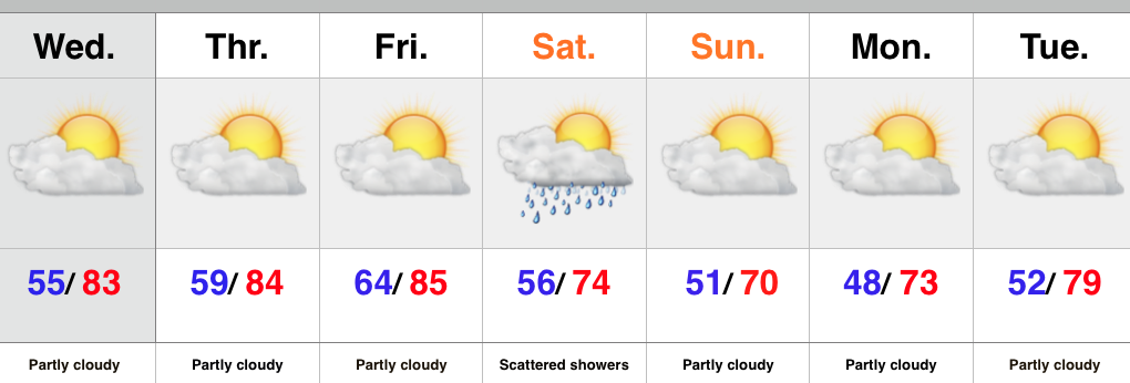
Dry And Warm Now; Cooler Times Over The Weekend…

Screen Shot 2015-09-15 at 9.51.31 PMHighlights:

  • Dry times continue
  • Front comes through mostly dry
  • Weekend cooling

High pressure will remain in control into the latter portion of the work week before giving way to an approaching cold front late Friday.  Dry conditions will continue before we introduce showers into the picture late Friday night into early Saturday.  Unfortunately this doesn’t appear to be a significant rain maker, but we’ll take what we can get.  The bigger story will be the push of much cooler air that arrives Saturday evening into Sunday.

Upcoming 7-Day Rainfall Forecast: 0.10″ – 0.25″

Permanent link to this article: https://indywx.com/2015/09/15/dry-and-warm-now-cooler-times-over-the-weekend/

IndyWx.com