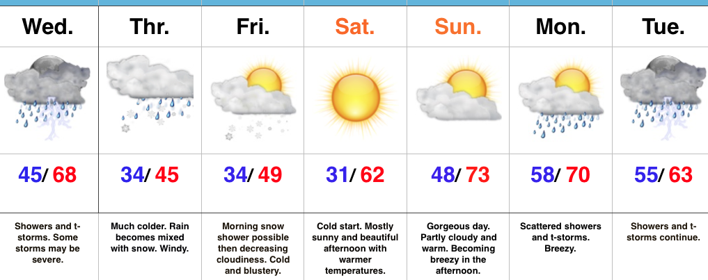
Wednesday: Potential Of A Busy Severe Weather Day…
 Highlights:
- Stormy Wednesday
- Snow mixes with rain Thursday
- Gorgeous weekend upcoming
- Busy times return next week
Remain Weather-Aware…Chilly, dry weather will continue this evening before showers and thunderstorms (non-severe) approach the western Indiana state line overnight and early Wednesday. Initially, showers and thunderstorms will impact western and northwestern portions of the state before all of central Indiana gets into the act by the afternoon hours. We continue to be concerned for the potential of an active severe weather day across the southern half of the state. All modes of severe weather will be possible, including tornadoes. As of this update (late Tuesday night), the greatest risk area appears to lie within areas from Indianapolis and points south and southeast. We’re most concerned for the period 2p-8p and will fine tune things early Wednesday if needed. Please remain weather-aware and have a means of getting the latest warnings.
We’ll shift gears rather abruptly from severe to more of a wintry feel to close the work week. Much colder air will spill into central Indiana Wednesday night and Thursday and leftover, wraparound, moisture will begin mixing with wet snowflakes Thursday afternoon and evening. Gusty northwest winds and the unseasonably chilly air will result in a downright ugly, raw day.
After early morning snowflakes Friday, drier air will begin to work into the region and result in increasing sunshine Friday afternoon. This will be a prelude to a gorgeous weekend: After a cold start Saturday, expect lots of sunshine and moderating afternoon temperatures. The warming trend continues Sunday as we top the 70° mark.
Our next storm approaches early next week. Clouds increase Sunday night and give way to showers and thunderstorms Monday into Tuesday. Questions come into play in regards to timing with this next cold front, but thinking (as of now) only slowly moves the front along, keeping unsettled weather in our forecast early week before a much cooler, drier period of weather by midweek.
Upcoming 7-Day Precipitation Forecast:
- Snowfall: 0.00″
- Rainfall: 2.00″ – 2.50″
 Highlights:
 Highlights:
 Highlights:
 Highlights: