Scattered Storm Chances Through Sunday Morning; Much Cooler Next Week…
 Highlights:
- Scattered storm chances continue
- Much cooler next week
- Midweek showers return
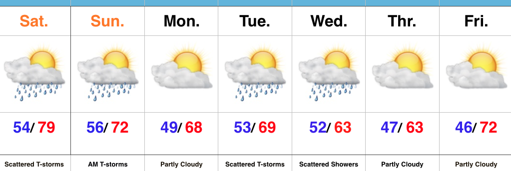
Watching For Afternoon And Evening Storms…We’re starting the day with low clouds, fog, and a chilly easterly breeze. That said, a warm front will begin to lift north this afternoon, allowing a warmer and increasingly muggy feel to return. Scattered thunderstorms will also increase in overall coverage later this afternoon and evening. While widespread heavy rains aren’t anticipated, localized heavy downpours are possible in slower moving, stronger storms.
Scattered showers and thunderstorms will remain Sunday morning, but a cold front will pass around lunchtime with drier air arriving by the afternoon hours. If you have plans outdoors Sunday, the afternoon and evening looks absolutely beautiful with a more pleasant air mass building in with those drier conditions.
Unsettled conditions return Tuesday into Wednesday with unseasonably cool air. As of now, the early outlook for the big race weekend and Memorial Day holiday is a dry one, with just a scattered shower chance Saturday. Stay tuned.
Upcoming 7-Day Precipitation Forecast:
- Snowfall: 0.00″
- Rainfall: 0.50″ – 1.00″ (Locally heavier amounts)
 Highlights:
 Highlights:
 Highlights:
 Highlights: