Category: 7-Day Outlook
-
Filed under 7-Day Outlook, Forecast, Heavy Rain, Rain, Severe Weather, snow, T-storms, Tornadoes, Unseasonably Cool Weather, Unseasonably Warm, Windy
-
April 4, 2017
Highlights:
- Stormy Wednesday
- Snow mixes with rain Thursday
- Gorgeous weekend upcoming
- Busy times return next week
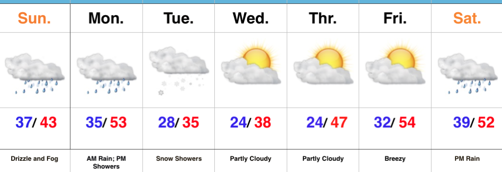
Remain Weather-Aware…Chilly, dry weather will continue this evening before showers and thunderstorms (non-severe) approach the western Indiana state line overnight and early Wednesday. Initially, showers and thunderstorms will impact western and northwestern portions of the state before all of central Indiana gets into the act by the afternoon hours. We continue to be concerned for the potential of an active severe weather day across the southern half of the state. All modes of severe weather will be possible, including tornadoes. As of this update (late Tuesday night), the greatest risk area appears to lie within areas from Indianapolis and points south and southeast. We’re most concerned for the period 2p-8p and will fine tune things early Wednesday if needed. Please remain weather-aware and have a means of getting the latest warnings.
We’ll shift gears rather abruptly from severe to more of a wintry feel to close the work week. Much colder air will spill into central Indiana Wednesday night and Thursday and leftover, wraparound, moisture will begin mixing with wet snowflakes Thursday afternoon and evening. Gusty northwest winds and the unseasonably chilly air will result in a downright ugly, raw day.
After early morning snowflakes Friday, drier air will begin to work into the region and result in increasing sunshine Friday afternoon. This will be a prelude to a gorgeous weekend: After a cold start Saturday, expect lots of sunshine and moderating afternoon temperatures. The warming trend continues Sunday as we top the 70° mark.
Our next storm approaches early next week. Clouds increase Sunday night and give way to showers and thunderstorms Monday into Tuesday. Questions come into play in regards to timing with this next cold front, but thinking (as of now) only slowly moves the front along, keeping unsettled weather in our forecast early week before a much cooler, drier period of weather by midweek.
Upcoming 7-Day Precipitation Forecast:
- Snowfall: 0.00″
- Rainfall: 2.00″ – 2.50″
Permanent link to this article: https://indywx.com/2017/04/04/wednesday-potential-of-a-busy-severe-weather-day/
Highlights:
- Strong-severe thunderstorm potential Wednesday
- Turning colder to close the week with snow showers
- Beautiful weekend ahead
Changeable Weather…The region will be in between storm systems Tuesday. We think clouds will hang tough and the storms from overnight will move off to the east. In place, scattered showers will dot the north-central Indiana landscape especially through the morning hours.
A new storm system will take aim on the region Wednesday and strong to severe thunderstorms will be possible. Many questions remain in regards to instability, but shear will be plentiful and we’ll have to keep a close eye on future developments over the next 24-36 hours. Stay tuned. From this distance, conditions seem favorable for super cells to develop especially across southern Indiana. We’ll transition from storms to more of a wintry-like feel Thursday and Friday and continue to think the air will grow cold enough to support mention of wet snowflakes mixing with the rain by Thursday evening into Friday morning.
As we flip the page into the weekend, high pressure will build into the Ohio Valley and support increasingly sunny conditions. After a cold and frosty start Saturday morning, temperatures will rebound nicely under that strong early-April sunshine.
Our next storm system won’t begin to impact the region until Sunday afternoon (increasing southwest winds) and Monday (scattered showers and thunderstorms).
Upcoming 7-Day Precipitation Forecast:
- Snowfall: 0.00″
- Rainfall: 2.00″ – 2.25″
Permanent link to this article: https://indywx.com/2017/04/03/topsy-turvy-forecast/
Highlights:
- Pleasant close to the weekend
- Rainy open to the work week
- Turning colder with rain and snow late week
Sunshine Gives Way To Rain…The weekend will end on a pleasant note as weak high pressure provides a variably cloudy sky today. That early-April sunshine will help temperatures top out in the lower 60s this afternoon.
Clouds will increase tonight and showers will develop during the overnight period. We’ll add a little instability to the mix by afternoon and introduce thunderstorms into the forecast Monday afternoon and evening. This storm system will then exit just as quickly as it arrives Monday night and help set up a pleasant Tuesday.
Eyes will then shift to a stronger storm system that will bring widespread showers and thunderstorms Wednesday, with locally heavy rain a good bet. As the storm wraps up over the Great Lakes region late week, colder air will spill into the state on gusty northwesterly winds. Backlash, wind-whipped, rain showers will transition to wet snow showers Thursday into Friday as colder air settles in. The good news here is that the weekend will get off to a nice start…after a cold beginning Saturday morning.
Upcoming 7-Day Precipitation Forecast:
- Snowfall: 0.00″
- Rainfall: 2.00″ 2.50″ with locally heavier totals
Permanent link to this article: https://indywx.com/2017/04/02/active-week-of-weather-ends-wintry/
Highlights:
- Nice weekend
- Rain returns Sunday night-Monday
- Strong storm potential Wednesday PM
- Cold close to the week
Sunshine Should Make An Appearance Today…The weekend is opening chilly, including wind chills around freezing this morning. Hang in there- sunshine should at least make an appearance later on this afternoon and Sunday certainly looks to be a brighter day, overall, before clouds increase late and give way to showers overnight into Monday morning.
We’re back to sunshine Tuesday before a stronger storm begins to impact the state Wednesday. A rather robust area of low pressure will track into the Great Lakes region Wednesday night and help pull a briefly warmer, increasingly moist air mass into the area. Potential is present for strong to severe thunderstorms Wednesday evening into the nighttime. We’ll then transition to a much cooler regime to close the week and with low pressure slowly pivoting through the Ohio Valley, showers will continue Thursday into Friday. In fact, the air may grow cold enough to allow for a few wet snowflakes to mix with the rain by Friday morning.
Upcoming 7-Day Precipitation Forecast:
- Snowfall: 0.00″
- Rainfall: 1.75″ – 2.25″
Permanent link to this article: https://indywx.com/2017/04/01/quiet-weekend-gives-way-to-an-active-work-week/
Highlights:
- Wet, chilly close to the work week
- Dry weekend
- Couple storms and turning colder late next week
Busy Weather Pattern Continues…An area of low pressure is swirling overhead this morning and will help promote periods of showers into the early afternoon before drier air begins to push in. Perhaps the bigger story will be falling daytime temperatures. By the evening rush, most neighborhoods should be deep into the 40s with a gusty northerly breeze at times.
We still forecast a dry weekend as high pressure builds in. Early fog and clouds will be slow to give way to sunshine Saturday, but by afternoon and evening we should see some breaks in the cloud cover. We’ll label Saturday as “mostly cloudy” before more in the way of sunshine works in for the second half of the weekend.
The dry times won’t last, unfortunately, and another storm system promises showers and thunderstorms as early as Monday. This will then be followed by a bigger storm the middle of the week that will, once again, lead to widespread showers and thunderstorms. The other point we want to drive home for late next week will be an increasingly chilly regime. Temperatures will fall Thursday and even though it’s beyond the current forecast period, sub-freezing lows are a good bet next weekend.
Upcoming 7-Day Precipitation Forecast:
- Snowfall: 0.00″
- Rainfall: 2.00″ – 2.50″
Permanent link to this article: https://indywx.com/2017/03/31/active-times-in-the-forecast-office/
1.) Morning showers and thunderstorms continue to impact north-central Indiana this morning and given the look to downstream trends on radar and satellite, it would seem like it’s going to be tough to get into any sort of significant sunshine this afternoon. This is great news as it’ll limit severe potential. That said, we still can’t rule out a severe thunderstorm this evening with large hail and damaging straight line winds of greatest concern. The updated (9a eastern) outlook from the Storm Prediction Center continues the “enhanced risk” for the southern half of Indiana.
2.) We bracket the hours of 2p-8p (couple hours earlier from yesterday’s thinking) as the period of potential most widespread strong to severe thunderstorms across central Indiana, and the HRRR forecast radar shows what the radar may look like this evening. Have a means of getting the latest warnings.
3.) Scattered showers will continue into Friday morning before drier air arrives during the evening hours.
4.) This drier trend Friday PM is one that will continue into the weekend. High pressure will supply mostly dry weather through the entire weekend (small shower chances return Sunday evening), including sunshine.
5.) Another active period of weather awaits next week, including multiple rain chances early and late week. The latter storm looks to be the bigger event with heavy rain and thunderstorm potential Wednesday into Thursday. 7-day rain numbers check in between 1.5″-2″ with locally heavier amounts.
6.) The story becomes a chilly one next weekend, and models suggest central Indiana may be dealing with frost and freeze conditions by next Saturday or Sunday morning.
Permanent link to this article: https://indywx.com/2017/03/30/thursday-morning-rambles-2/
Highlights:
- Next weather maker arrives to close the work week
- Dry weekend coming
- Next storm system on deck
Rain Gear Needed To Close The Work Week…Wednesday will dawn with low clouds and areas of fog in spots, but that should diminish and possibly give way to a couple looks of the sunshine before our next storm system quickly approaches. If we see any sun Wednesday it won’t last long, as clouds will once again be on the increase Wednesday afternoon with a scattered shower possible. Rain coverage will become more widespread Thursday, and we’ll introduce a rumble of thunder into the forecast Thursday afternoon/ evening. Showers will continue Friday before scattering Friday afternoon.
The decreasing Friday afternoon rain chances signals a drier change that we’ll enjoy for the weekend (perfect timing)! High pressure will build into the region and support dry conditions. The temperature forecast is a bit tricky Saturday. We’re banking on a mostly cloudy sky that would limit highs into the middle 50s. Should we see more in the way of sunshine than currently expected, highs would zoom close to 60° Saturday. Dry conditions remain Sunday.
Our next storm system will result in increasing rain and storm coverage Monday afternoon, continuing into the day on Tuesday. If we look just beyond the forecast period, a shot of unseasonably cold air could send temperatures to sub-freezing levels by the latter parts of next week…
Upcoming 7-Day Precipitation Forecast:
- Snowfall: 0.00″
- Rainfall: 1.00″ – 1.50″
Permanent link to this article: https://indywx.com/2017/03/28/wet-close-to-the-work-week-but-a-dry-weekend-is-ahead/
Highlights:
- Couple rounds of rain this week
- Periods of dry weather in between
- Nice weekend ahead
Not A Bad Week…The work week is off to a dry start, but a fast-moving storm system promises to trigger showers later this afternoon into the evening hours across central Indiana, and perhaps some stronger thunderstorms across southern Indiana. With this being a quick moving storm, dry conditions will return as early as tomorrow. Dry conditions remain Wednesday with periods of sunshine and pleasantly mild temperatures.
Another storm system will deliver showers and thunderstorms Thursday into Friday. Temperatures will remain mild through Thursday, but Friday will feature cooler conditions (near seasonal norms). This shouldn’t be a particularly heavy rain maker, but expect wet times Thursday into Friday.
The good news in this forecast is the timing between storm systems should allow for a beautiful weekend ahead. We forecast sunshine to return and while it’ll be a touch cooler, that high early April sun angle will provide for a pleasant feel.
Upcoming 7-Day Precipitation Forecast:
- Snowfall: 0.00″
- Rainfall: 0.75″ – 1.25″
Permanent link to this article: https://indywx.com/2017/03/27/couple-storm-systems-to-deal-with-before-a-pleasant-weekend/
Highlights:
- Shower and t-storm chances increase late
- Another storm system arrives Monday afternoon
- Late-week questions
Active Period…Most of Saturday across central Indiana will feature dry conditions. It’s not until we get to Saturday evening and into the overnight that shower and thunderstorm coverage will begin to really increase in earnest. Periods of showers continue Sunday (especially the first of the day day).
A dry start to Monday will give way to increasing cloudiness with showers and thunderstorms arriving by the afternoon and evening hours. This fast-moving area of low pressure will then depart as quickly as it arrives and leave us with dry conditions Tuesday into Wednesday.
We’re then left with late-week questions. The GFS is significantly cooler than the European and we’ll craft this portion of the forecast with a blend- leaning more in the direction of the warmer European solution. Showers and thunderstorms are likely Thursday into Friday.
Upcoming 7-Day Precipitation Forecast:
- Snowfall: 0.00″
- Rainfall: 1.50″ – 2.00″
Permanent link to this article: https://indywx.com/2017/03/25/rain-chances-go-up-late/
Highlights:
- Another cold morning
- Turning unsettled
- Warmer heading into early next week
Warmer, But Rain Chances Return…Before we enjoy the warmer temperatures to close the week, we have one more very cold morning to go through. Many central Indiana neighborhoods are once again starting the day in the mid to upper 20s. Though we’ll add more clouds to our Thursday forecast (compared to all of that Wednesday sunshine), it won’t prevent temperatures from moderating close to seasonal levels later this afternoon.
Though we’ll mention a quick passing shower chance Friday, most of the day should be dry and the bigger story will actually be temperatures that approach 70° by the afternoon with periods of sunshine. Sounds like a recipe for getting out of the office early and finding a local patio, huh?!
Unfortunately, shower chances will be on the uptick this weekend and while it won’t rain the entire time, really any time of the weekend is fair game for the potential of a shower or perhaps a thunderstorm. As of now, best shower coverage should be Sunday.
Shower and thunderstorms chances continue early next week (Monday afternoon through Tuesday morning) before drier air and slightly cooler temperatures return the middle of next week.
Upcoming 7-Day Precipitation Forecast:
- Snowfall: 0.00″
- Rainfall: 1.00″ – 1.50″
Permanent link to this article: https://indywx.com/2017/03/23/turning-warmer-but-unsettled/