October 2023 archive

Saturday Morning Rambles…

Updated 10.14.23 @ 7:43a I. An upper low and trough of low pressure will lead to a return of cloudiness, additional nuisance variety showers along with gusty winds and falling…

You must be logged in to view this content. Click Here to become a member of IndyWX.com for full access.  Already a member of IndyWx.com All-Access?  Log-in here.

Permanent link to this article: https://indywx.com/2023/10/14/saturday-morning-rambles-12/

Tracking 2 Storms In The Week Ahead…

Updated 10.13.23 @ 7:25a

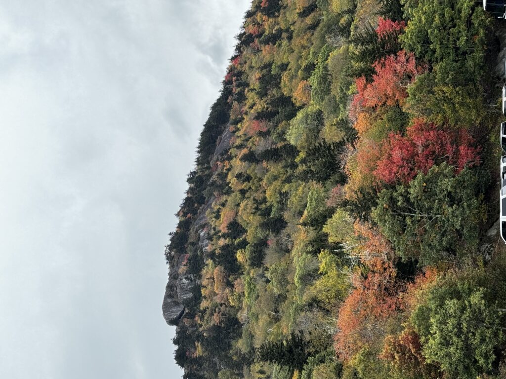
I’ve had the opportunity this week to spend time with family and loved ones in the gorgeous western NC and eastern TN mountains. Fall foliage is starting to pop above 2,000 feet, especially after the cooler air this week.

At any rate, thank you for your patience and flexibility this week as posts have been a bit off schedule. We’ll resume “normal programming” Saturday.

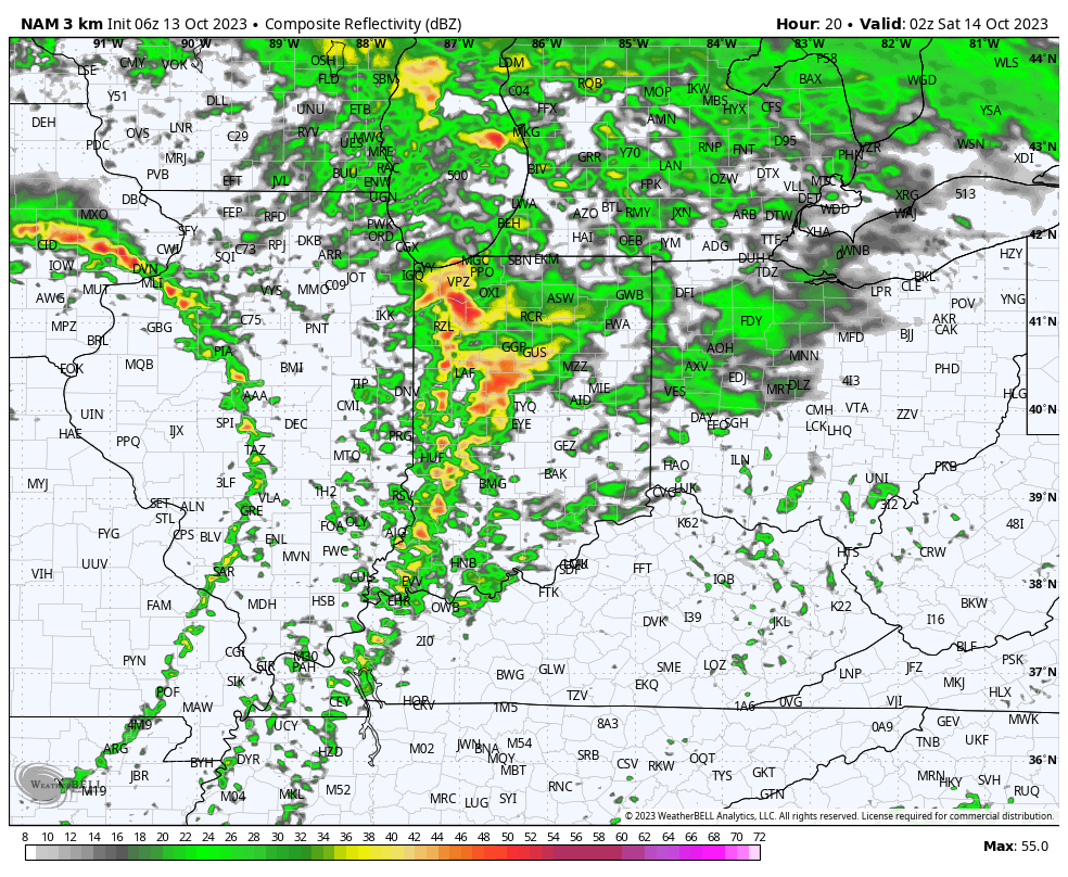
When we look ahead to this week, there are 2 storms of note. The easy and obvious first system will deliver a round of storms this evening. A few of these will have gusty winds and a few leftover “backlash” showers will continue through the weekend as the upper low swirls overhead. Once again, we’ll turn much cooler tonight and continue into the new week.

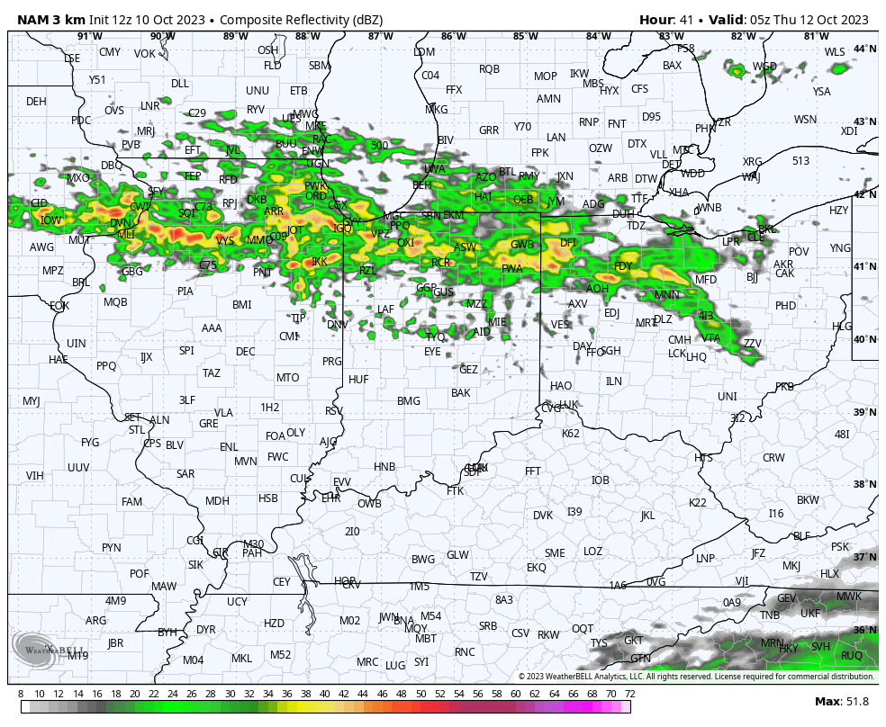
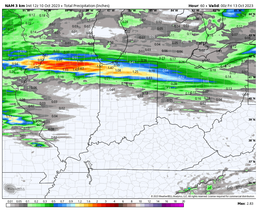
Rain and storms will roll across the state tonight.

Rainfall totals of 0.25” to 0.75” will be common for central and southern Indiana with heavier amounts of 1” to 1.5” across the northern 1/3 of the state.

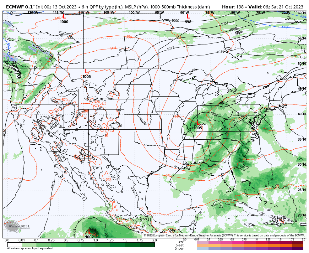
Our second system is much more complex and will come into the picture late week (next Friday/ Saturday time frame). Guidance agrees on the energy becoming cut off from the main steering flow but is far from etched in stone with the specifics at this distance. It’ll certainly be a topic of discussion in the days ahead.

Permanent link to this article: https://indywx.com/2023/10/13/tracking-2-storms-in-the-week-ahead/

LR Update: Checking In On The Pattern Drivers To Close October…

Updated 10.12.23 @ 10:50a

As we roll into the second half of October, a look at the primary pattern drivers suggests there should be a lack of any sort of sustained above normal temperatures.

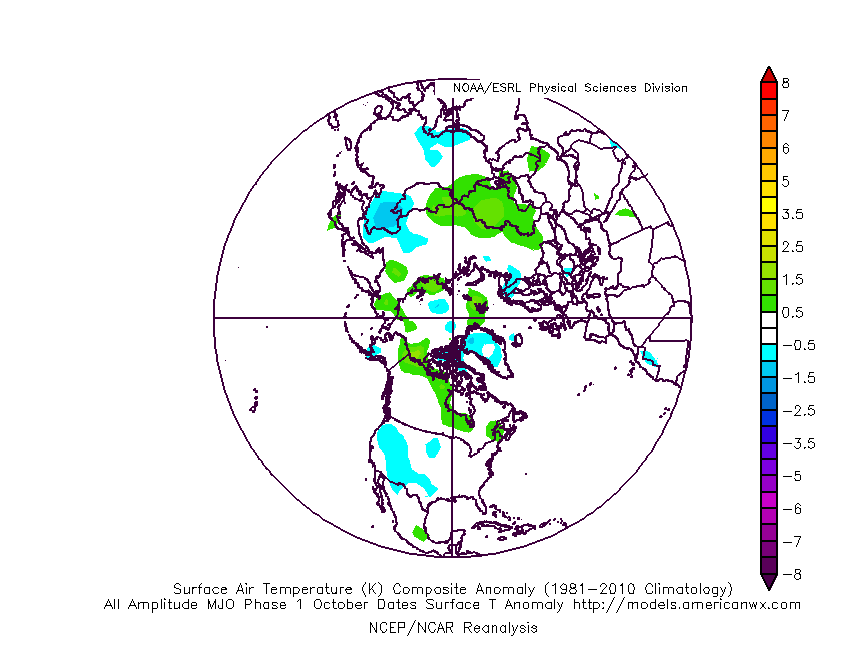
The PNA (image 1) should remain mostly in a positive state over the next couple weeks while the EPO (image 2) is expected to be in a neutral to negative state.

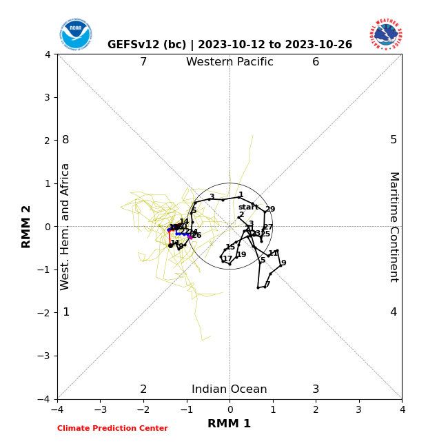
Furthermore, the MJO is forecast to sneak into Phase 1 late month. This is the correlation in October:

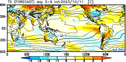
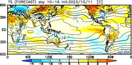
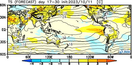
It’s hard to find much at fault with the NEW JMA Weeklies posted earlier today.

Temperatures

Week 1

Week 2

Weeks 3-4

Precipitation should run average to slightly below normal over the span of the upcoming (2) weeks:

Permanent link to this article: https://indywx.com/2023/10/12/lr-update-checking-in-on-the-pattern-drivers-to-close-october/

Briefly Warmer; Blustery Close To The Week With Rain And A Few Storms…

Updated 10.11.23 @ 7:42a

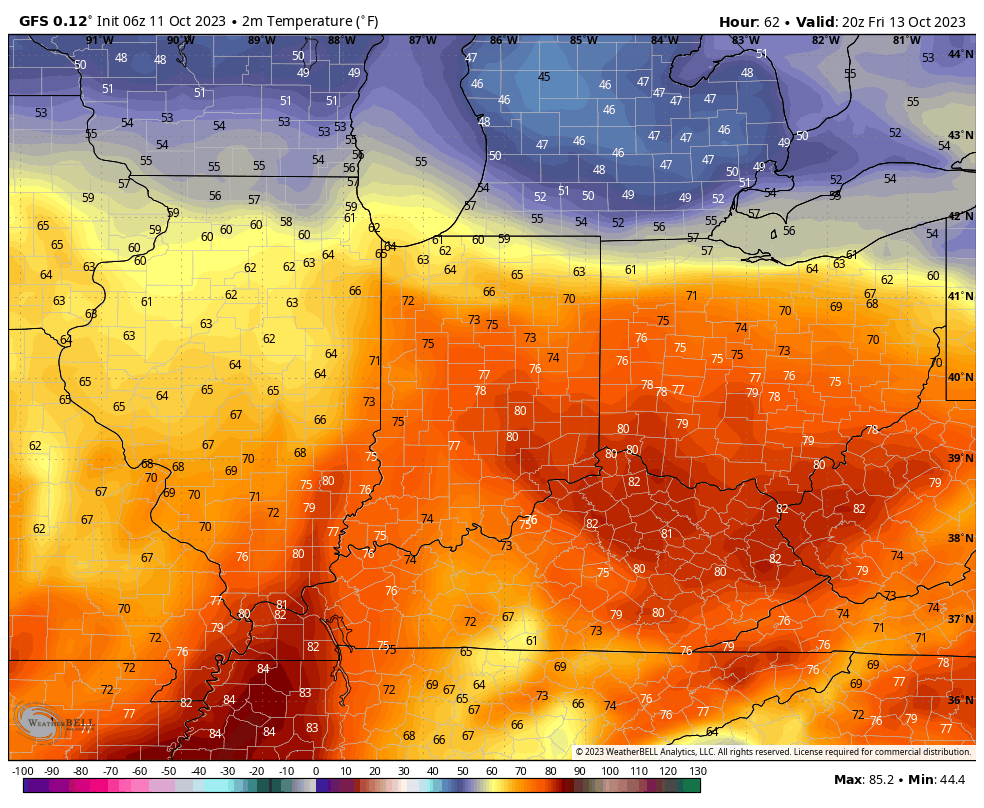
A cold front and associated area of low pressure will move through the Ohio Valley as we close the week. Briefly warmer air will surge north into the region Thursday and Friday with temperatures flirting with 80° both days.

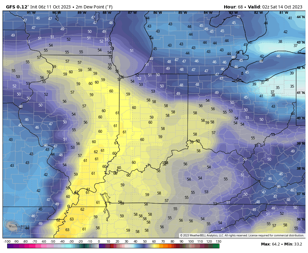
Moisture levels will also increase as dew points creep up closer towards 60°.

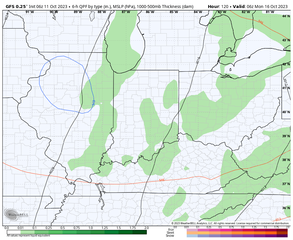
A weakening area of rain and embedded storms will rumble into the state late Friday and Friday night. Widespread severe weather isn’t expected but the Storm Prediction Center outlines the far western portion of the state in a marginal risk, primarily for a wind threat. We still bracket 0.25” to 0.75” rain potential.

Speaking of wind, non-thunderstorm gusts towards 30 MPH can be expected Friday and Saturday.

With the cold core upper low hanging around, additional spotty showers, mixed with graupel, can be expected over the weekend into early next week.

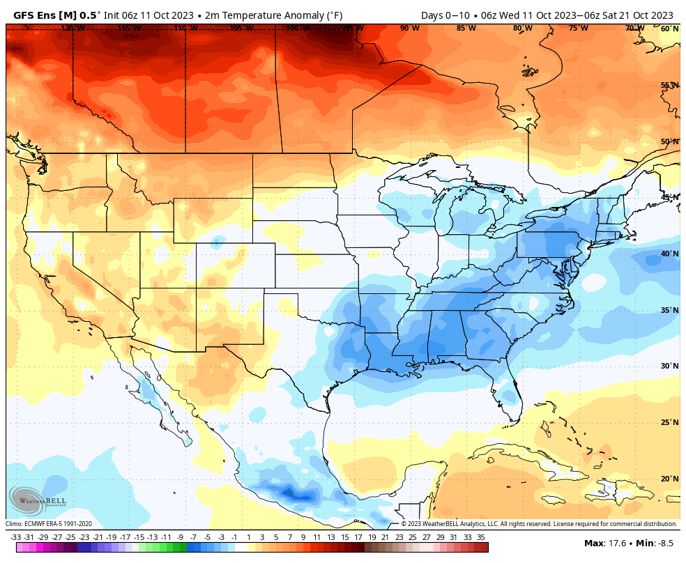
The theme over the next couple weeks is for cooler than normal conditions to dominate overall.

Permanent link to this article: https://indywx.com/2023/10/11/briefly-warmer-blustery-close-to-the-week-with-rain-and-a-few-storms/

Lunchtime Rambles: Time To Start Thinking About Stocking That Wood Pile…

Updated 10.10.23 @ 12:53p

I. A warm front will lift north through Indiana Wednesday. This will serve as a focal point for locally heavy rain across the northern tier of counties Wednesday night into Thursday morning. Most high resolution modeling keeps central Indiana out of the heavy rain axis but a passing shower is certainly possible.

II. A cold front and associated area of low pressure will rumble across the Ohio Valley Friday with more widespread rain (embedded thunder) impacting central Indiana Friday evening and Friday night.

III. A cold core upper low will drop southeast Sunday into Monday. With the cold air aloft and just enough daytime heating, showers (potentially mixed with graupel) will develop. Otherwise, anticipate a “raw” close to the weekend and open to the new work week.

IV. Our recent chilly turn will only be reinforced that much further behind the passage of Friday’s cold front. Most of next week is looking below to well below normal. Time to start thinking about stocking up that wood pile. Long Range charts show another big blast of the coldest air so far this season the following week…

Permanent link to this article: https://indywx.com/2023/10/10/lunchtime-rambles-time-to-start-thinking-about-stocking-that-wood-pile/

Active Mid And Late October; Another Unseasonably Cold Shot On Deck…

Updated 10.09.23 @ 7:35a

We’re opening the work week with a few scattered clouds and temperatures around the 40° mark. We’re in a pattern that will feature predominantly cooler to colder than normal temperatures over the next 10-14 days with a couple exceptions. We’ll call it a sea of cool with an island of warmth (Thursday and Friday). The relatively warmer temperatures come after the passage of a warm front and ahead of a cold front. The “in between” will feature another period of unsettled and stormy weather to close the work week.

The overall upper air pattern shows that Hudson Bay blocking high and tendency for an eastern trough through the upcoming 2 week period. Another big cold shot will roll in here over the weekend and into the early Week 2 time period.

After a dry start to the week, rain chances will return late Wednesday and early Thursday (warm front) and again directly ahead of the cold front that will sweep through here Friday evening. Rainfall numbers with the passage of this system should check in between 0.25” and 0.75” for most of the region.

As we look ahead, a continued chilly pattern seems to be in store with additional storm dates that include:

10/19-10/20

10/23-10/24

Down the road, the strongly positive PNA and neutral to negative EPO should keep the chill flowing for the most part over the coming couple weeks. Eventually, these progressively colder shots will likely generate the 1st eastern flakes of the season, including for our friends in the beautiful high ground of those east TN and western NC mountains.

Permanent link to this article: https://indywx.com/2023/10/09/active-mid-and-late-october-another-unseasonably-cold-shot-on-deck/

VIDEO: Persistent Eastern Trough Over The Next Couple Weeks…

Updated 10.08.23 @ 6a

You must be logged in to view this content. Click Here to become a member of IndyWX.com for full access.  Already a member of IndyWx.com All-Access?  Log-in here.

Permanent link to this article: https://indywx.com/2023/10/08/video-persistent-eastern-trough-over-the-next-couple-weeks/

Trend Hasn’t Been Our Friend As Of Late Around The Holidays; Reason To Believe This Year Is Different?

Updated 10.07.23 @ 6:09a

Though officially, we’re only a couple weeks into autumn, attention here has begun to shift towards the potential predominant pattern as we push into the holiday season.

A quick, simple look back over the most recent November and December patterns is a sight that generates anxiety for most winter lovers. At a time when the majority of even non-winter lovers would like snow (i.e. the holidays), well above normal temperatures, and almost record warmth has become all too common over the years.

November 2015-2022

December 2015-2022

Is there reason to believe that could be different this year, especially with our base transition to El Nino? Simply put, not so fast my friend. El Nino winters are notorious for getting off to slower, warm starts. Our research shows that many times November can start cold but that the December pattern flips warmer around these parts. That’s, obviously, not to say it “has” to be that way. Many other factors contribute to the overall regime, but just that when you simply bundle all 1st year Nino events together, it’s more typical than not to find things play out such as illustrated above.

Let’s take a more specific look at our analog package (’82-’83, ’91-’92, ’02-’03, ’09-’10, and ’15-’16) and see what that suggests may be in store as we begin to set our eyes on the holidays.

November: Slightly above normal, locally. Unseasonably cold west and unseasonably warm New England are the headliners.

December: Greatest warm anomalies are centered over the Ohio Valley, in what otherwise is a large-scale warmer than normal regime from the Plains east.

January: The pattern begins to really flip around with cold bleeding southeast as the northern Plains and Northwest turn warmer than normal.

What does this all mean to me? While there’s only one that knows the future, if I was a betting man, I’d lean towards another holiday season that features above normal temperatures and most likely a greater than normal chance of below average December snowfall. I’d anticipate a few cold shots in November and the possibility of one or 2 accumulating snow events that gives way to the overall warmer idea in December. There’s always the chance the pattern begins to shift that last week of December for the colder January look… That’s the hope we’ll leave you with in this post in what otherwise will likely be a warmer than normal month as a whole.

Permanent link to this article: https://indywx.com/2023/10/07/trend-hasnt-been-our-friend-as-of-late-around-the-holidays-reason-to-believe-this-year-is-different/

LR Discussion: Pattern Discussion Through The Remainder Of October And Into November…

Updated 10.06.23 @ 7:56a

As we type this, we’re in the midst of the season’s 1st big blast of chilly air. These shots will become progressively cooler (colder) in the coming weeks and months. Speaking of that, we’re also working on a post that we’ll unveil over the weekend looking specifically at the upcoming holiday season and what our analog package/ respective SST configuration says we may have in store this season.

For the purpose of this post, we’ll focus squarely on the pattern through the remainder of October.

As we typically do, the pattern drivers (+ PNA and – EPO) both suggest a ‘mean’ trough should take up shop across the eastern 1/3 of the country over the next couple weeks. What’s interesting is that the updated European Weeklies also suggest this general theme should continue into at least mid-November. Despite a favorable setup with respect to the PNA/ EPO, the model tries to wash out the chill and hints at a ridge down the road. In my humble opinion, this is the model feeding back on itself and once again showcasing an inability to see below normal temperatures in the longer range. We’ve shown time and time again over the summer and even into the early fall where the model is “forced” to cool the closer we get to a given period and believe that will, once again, be the case this go around, especially with the anticipated positive PNA and negative EPO.

The Pacific North American pattern (PNA) is expected to remain in a positive state through the majority of the upcoming 5-6 weeks.
The East Pacific Oscillation (EPO) is anticipated to remain largely in a negative state through the upcoming 5-6 weeks.

The upper pattern, illustrated with last night’s European Weeklies, is one that breaks the trough down towards Halloween. While there is a possibility of some brief warming around this timeframe, I suspect we’ll once again look back at the model having to correct colder over the east as we rumble into November. More on that in a moment.

Week 1: 10/5 through 10/11

Week 2: 10/11 through 10/18

Week 3: 10/18 through 10/25

Week 4: 10/25 through 11/1

The period ends with a warmer look around Halloween and while this is on the table, it’s also a look that should promote building heights over AK and western Canada and another period of blocking with a subsequent cold trough developing over our neck of the woods and the central/ east as we rumble through into November. The model is seeing the building heights, but not picking up on the magnitude of a downstream trough and associated colder pattern, IMO. Frankly, this 500mb look is capable of producing very cold weather sometime during mid-November and I suspect the model will have to start playing catch up as we move forward.

Permanent link to this article: https://indywx.com/2023/10/06/lr-discussion-pattern-discussion-through-the-remainder-of-october-and-into-november/

VIDEO: Secondary Cold Front Hits This Evening; A Little “Frost On The Pumpkin” For Some Sunday Morning…

Updated 10.06.23 @ 7:36a

You must be logged in to view this content. Click Here to become a member of IndyWX.com for full access.  Already a member of IndyWx.com All-Access?  Log-in here.

Permanent link to this article: https://indywx.com/2023/10/06/video-secondary-cold-front-hits-this-evening-a-little-frost-on-the-pumpkin-for-some-sunday-morning/

IndyWx.com