
Published 10.01.23 @ 7a
We do it every year around this time and while some years have certainly been tougher than others, there’s always something special about this time on the calendar. Perhaps it’s the cooler days, the longer nights, the return of football season, or better yet the thoughts (at least to this winter lover) of the first flakes of the season that loom in the not too distant future. However you view this time of year, I hope you can find a way to enjoy the upcoming winter season.
Like most years, there will likely be a little something for everyone, and before diving in too far, we always like to remind folks that long range forecasting is always a challenge, albeit a welcome one at that. While there’s simply no way to be certain about specifics 2-5 months in advance, more times than not, we can at least provide an idea of the overall upper pattern that should generate predominant precipitation and temperature regimes in the colder months ahead.
Without further ado, lets dive in…
We’re in uncharted territory, at least compared to the past (3) years. After a rare triple dip Nina event, a strong El Nino is here and anticipated to stick around, at least in a moderate fashion, through the winter.
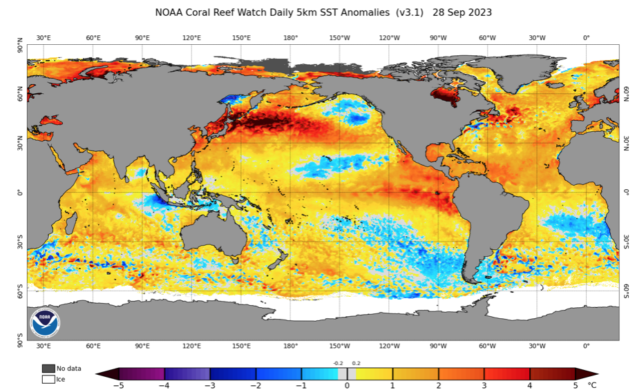
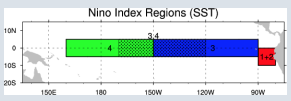
It’s important to note that not one Nino event is identical to another. What’s of particular interest with this year’s event is that a lot of the longer range model guidance begins to weaken the Nino as we get into the middle and latter part of the winter, while migrating the warmest anomalies west (more into the central region: region 3 and region 3.4). By the way, here’s an interesting article that sheds more light on the various regions and indices.
Ultimately, that is the golden ticket to what this winter becomes in my opinion. While far from etched in stone, it’s my belief that when you have a Nino event coming off it’s peak during the winter, there’s a better opportunity to get the warmest anomalies more into the central regions as the weakening takes place. Should this happen then we’re talking about increasing prospects of cold and snow. Meanwhile, if the warmest SST anomalies remain tucked into 1+2, it’ll likely be another ugly winter for snow and cold lovers.
On that note, the past 5 winters have only produced an average 14.1″ of snow in Indianapolis. Only ’20-’21 was close to average at 22.2″. To add salt to the wound, if you take out the record snowiest ’13-’14 (whopping 52.2″), our 10 year snow average is 12.6″.
Lets take a look at some of the various modeling for the upcoming meteorological winter (December through February).
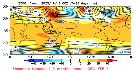
JMA Seasonal
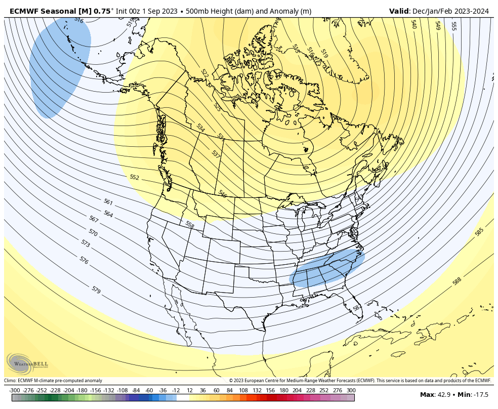
European Seasonal
Canadian Seasonal
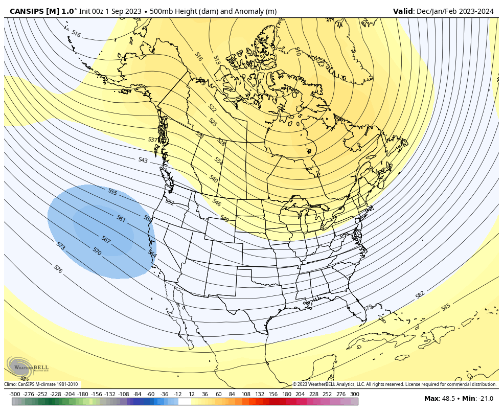
The seasonal guidance shown above is the most aggressive, collectively, I can recall for quite some time from this distance. Note each of the models above indicate the opportunity for blocking with the active southern stream underneath that we come to expect in an El Nino.
We built our analog set (first shared with Clients on 9/3) with the baseline including 1st year moderate to strong Ninos.
- 1957-1958
- 1972-1973
- 1991-1992
- 2002-2003
- 2009-2010
- 1982-1983
- 2015-2016
In addition, we’re also looking at critical SST configuration in the NPAC and northwest Atlantic. Out of the list above, heaviest focus centers on ’82-’83, ’91-’92, ’02-’03, ’09-’10, and ’15-’16.
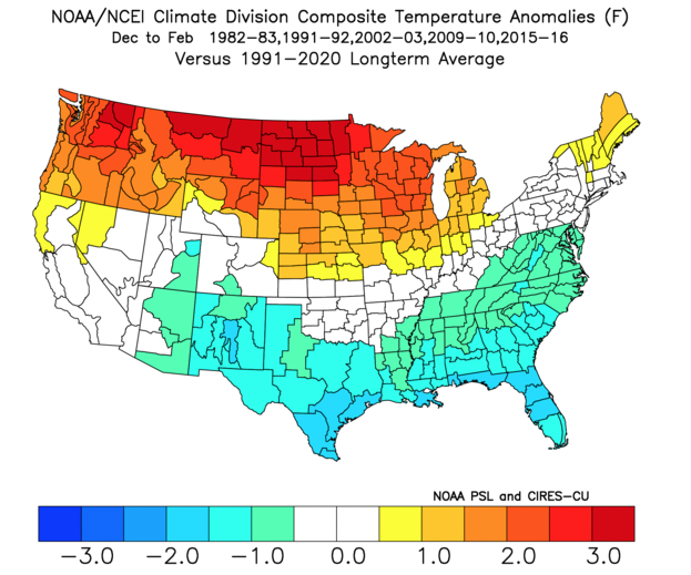
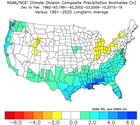
A blend of those years gives us the following temperature and precipitation pattern for meteorological winter:
Temperatures
Precipitation
What does this all mean to me: Central Indiana
Last year we thought the winter would get off to a much quicker, harsher start than years past. While November didn’t disappoint from a snowfall perspective (2.8″ compared to an average of 0.8″), it was still a slightly warmer than normal month. The cold came in December, but it was a “dry” cold with below normal snowfall (1.6″ compared to an average of 6.4″).
The more I look at trends for this winter, the more I like the idea of increased high latitude blocking compared to years past along with the evolving, more central based Nino event. With that said, recent trends have me a bit hesitant to go “all in” on the potential of this winter. We’ll lean slightly warmer than normal with slightly below normal snowfall for the winter as a whole. That said, local perception will be interesting as I envision a snowier winter compared to the past couple years. While the primary storm track should be suppressed this year with below normal precipitation, thanks to the El Nino, that doesn’t necessarily mean we’re in for a snowless winter.
The numbers please…
Temperatures: December through February averaging 0.5° to 1° above normal as a whole
Precipitation: Below normal precipitation is expected through the 3 month winter period (75% of normal is our call) with slightly below normal snowfall. We forecast 20″ of snow (1st flake to last flake).
Whatever the winter provides, I hope you and your family enjoy and stay safe!