September 2023 archive

Toasty Open To October Takes A Back Seat Late Next Week…

Updated 09.30.23 @ 7:44a

There’s no reason to waste a bunch of pixels on our weather over the next 5 days. Despite morning fog in spots (a byproduct of just enough lingering moisture from rain earlier this week along with the longer nights) we’re talking about a “rinse and repeat” regime with plentiful sunshine and seasonably cool mornings warming quickly to well above normal levels during the afternoon.

High pressure will dominate our weather through Wednesday with dry skies.

2 cold fronts will have eyes on our region late week. The 1st boundary will increase our cloud cover and offer up a passing shower Thursday. The 2nd cold front will sweep through the Ohio Valley around a week from today and provide a shot of much cooler air to close the weekend and open the following week.

Moisture levels don’t look impressive with either frontal passage at this point. If we can squeak out 0.10″ we’ll have to count ourselves lucky.

The coolest air of the young autumn season will filter into our region next weekend. A total reversal of the upper air pattern we open the period with…

Permanent link to this article: https://indywx.com/2023/09/30/toasty-open-to-october-takes-a-back-seat-late-next-week/

VIDEO: Warm Days With Plentiful Sunshine Into Early Next Week; True Fall Feel Takes Hold Late Next Week…

Updated 09.29.23 @ 7:42a

You must be logged in to view this content. Click Here to become a member of IndyWX.com for full access.  Already a member of IndyWx.com All-Access?  Log-in here.

Permanent link to this article: https://indywx.com/2023/09/29/video-warm-days-with-plentiful-sunshine-into-early-next-week-true-fall-feel-takes-hold-late-next-week/

VIDEO: Dry Times Return; “Jailbreak” Pattern Next Week…

Updated 09.28.23 @ 7:50a Our warm open to October will reverse in big time fashion week after next. In other exciting news, our annual winter outlook will be posted Sunday…

You must be logged in to view this content. Click Here to become a member of IndyWX.com for full access.  Already a member of IndyWx.com All-Access?  Log-in here.

Permanent link to this article: https://indywx.com/2023/09/28/video-dry-times-return-jailbreak-pattern-next-week/

VIDEO: Another Unsettled Day; Page Turns To Extended Dry And Unseasonably Warm Stretch To Open October…

Updated 09.27.23 @ 7:41a

You must be logged in to view this content. Click Here to become a member of IndyWX.com for full access.  Already a member of IndyWx.com All-Access?  Log-in here.

Permanent link to this article: https://indywx.com/2023/09/27/video-another-unsettled-day-page-turns-to-extended-dry-and-unseasonably-warm-stretch-to-open-october/

Storms Fire This Evening; Early October Blow Torch…

Updated 09.26.23 @ 7a

A closed upper low will pivot across the Ohio Valley over the next couple days. Our quiet start this morning will give way to “bumpy” times by evening. We expect scattered, but strong to severe storms to fire up after 5p. A couple of these could produce hail/ wind and we can’t rule out a quick spin up tornado with this setup.

The Storm Prediction Center highlights most of the area in a “marginal” risk of severe weather today, and I wouldn’t be surprised if a portion of this area (particularly western and central IN) is upgraded to a “slight” risk at some point.

Storms should become most widespread just before sunset and continue into the overnight hours.

As we transition into Wednesday, morning convection will likely still linger before greatest concentration of rain and storms pivots to eastern and southeastern parts of the state by afternoon.

By the time all is said and done, many central Indiana rain gauges can expect to pick up between 0.50” and 0.75” of rain but there will be a few lucky folks that accumulate much more (type setup capable of 1”-2”+ in localized areas).

As we get set to rumble into the weekend, drier air will return and plentiful sunshine is expected. We still expect an unseasonably warm open to October with an extended stretch of days in the lower to middle 80s- good for 10° to 15° above the norm.

Permanent link to this article: https://indywx.com/2023/09/26/storms-fire-this-evening-early-october-blow-torch/

VIDEO: Rain And Embedded Thunder Returns; Warm Open To October…

Updated 09.25.23 @ 7:48a

You must be logged in to view this content. Click Here to become a member of IndyWX.com for full access.  Already a member of IndyWx.com All-Access?  Log-in here.

Permanent link to this article: https://indywx.com/2023/09/25/video-rain-and-embedded-thunder-returns-warm-open-to-october/

VIDEO: Better Rain Chances Return And Doubling Down On The Colder Mid-Oct Pattern Shift…

Updated 09.24.23 @ 10:44a

You must be logged in to view this content. Click Here to become a member of IndyWX.com for full access.  Already a member of IndyWx.com All-Access?  Log-in here.

Permanent link to this article: https://indywx.com/2023/09/24/video-better-rain-chances-return-and-doubling-down-on-the-colder-mid-oct-pattern-shift/

Cruising Into A Warm Close To September/ Open To October; Mid-Month Changes Brewing?

Updated 09.23.23 @ 7:50a

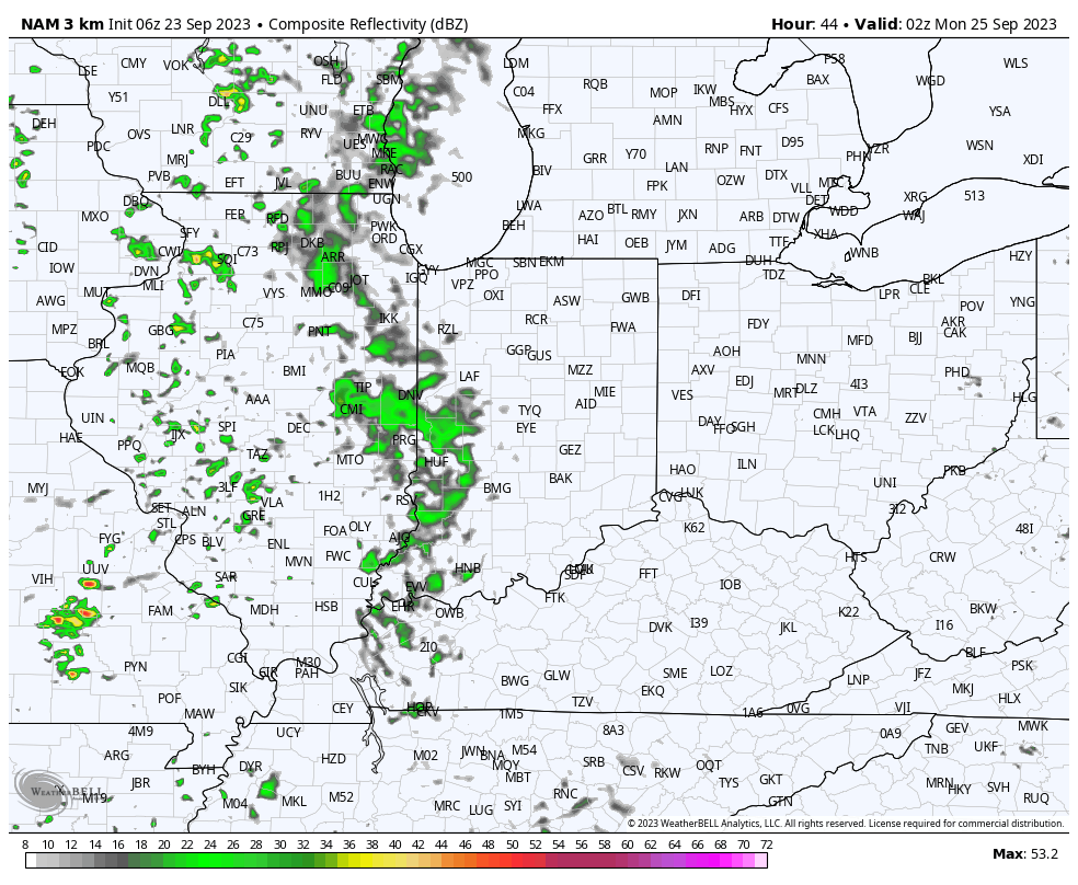
Dry conditions will prevail through 99.9% of the weekend and for most, 100% of the time. A few very light showers may sneak into western counties Sunday night, but light is the key word. With such a dry airmass in place, most of this activity is expected to arrive in a weakening state.

The temperature pattern is “easy peasy” this week as unseasonably mild temperatures dominate. An extended stretch of highs around 80° can be expected in the week ahead.

An upper low will pivot out of the Mid West and through the Ohio Valley midweek. This will deliver more in the way of unsettled weather for our neck of the woods, but we’re still not overly excited about rain chances.

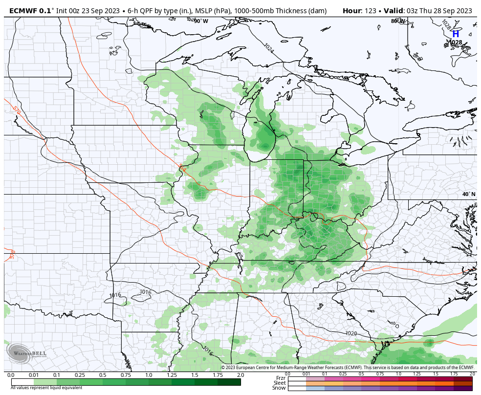
Scattered showers will build into the picture Wednesday and Thursday, courtesy of the aforementioned upper low pressure system. From this distance, rainfall totals are expected to be light (mostly in the 0.10″ to 0.25″ range) and certainly not uniform in nature.

As we head into next weekend and the beginning of October (can you believe it?!), the ridge will expand overhead and lead to a return of quiet and milder times.

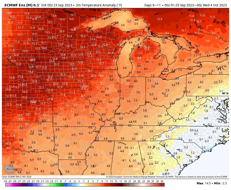
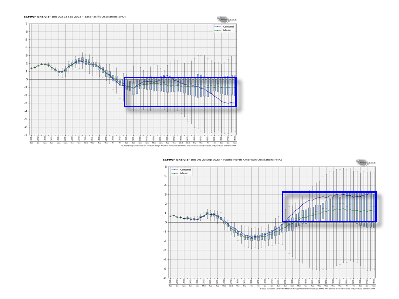
Down the road, as mentioned in this week’s long range report, I still would be very suspicious of the warm paint blob shown on most modeling towards mid-October. The thinking here is the negative EPO and positive PNA will begin to do work, leading to a fairly sizable shift in the ‘mean’ pattern…

Permanent link to this article: https://indywx.com/2023/09/23/cruising-into-a-warm-close-to-september-open-to-october-mid-month-changes-brewing/

Long Range Outlook Into October: Reason To Be Suspicious Of The Warm Look…

Updated 09.22.23 @ 10:41a

The pattern over the next 10 days will continue the same warmer than normal theme we’ve grown accustomed to as of late. Keep in mind that “normals” have now fallen into the lower to middle 70s for highs and lower 50s at night. Certainly far from a “blow torch,” but temperatures will run 5° to 10° above the norm as we put a bow on September.

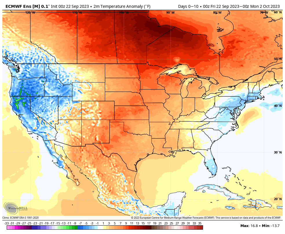
Short-term rain chances will be handled in our daily videos. Guidance continues to differ widely on our mid week system. Needless to say, we’re not overly optimistic on the wetter solutions as of now, but will closely monitor to see if more consistency develops down the road.

As a whole, the pattern continues to look drier than normal over the next couple weeks overall.

Week 1

Week 2

While guidance continues to look warm into early and mid October, I have to raise an eyebrow based on the latest teleconnection trends. We note the EPO trending negative while the PNA pops positive. These drivers should force a colder look Week 2 into Week 3 and I would suspect guidance will cool significantly as we get closer.

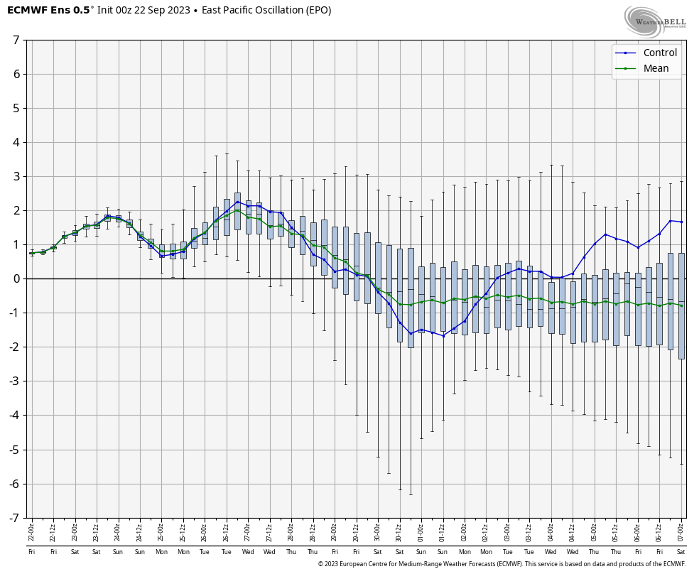
Further down the road, it’ll be important to keep tabs on western Pacific typhoon activity and the Madden Julian Oscillation. There are signs we may finally start to see the MJO become more of a player in the pattern towards mid October. Time will tell.

In the meantime, keep a close eye on guidance Week 2 into Week 3 as this will be the first real test case to revisit so far this meteorological fall season…

Permanent link to this article: https://indywx.com/2023/09/22/long-range-outlook-into-october-reason-to-be-suspicious-of-the-warm-look/

VIDEO: Only A Couple Exceptions To An Otherwise Very Quiet Couple Of Weeks…

Updated 09.21.23 @ 7:46a

You must be logged in to view this content. Click Here to become a member of IndyWX.com for full access.  Already a member of IndyWx.com All-Access?  Log-in here.

Permanent link to this article: https://indywx.com/2023/09/21/video-only-a-couple-exceptions-to-an-otherwise-very-quiet-couple-of-weeks/

IndyWx.com