December 2019 archive

Merry Christmas! The Weather Pattern Takes On A More Active Look To Close The Year…

You must be logged in to view this content. Click Here to become a member of IndyWX.com for full access.  Already a member of IndyWx.com All-Access?  Log-in here.

Permanent link to this article: https://indywx.com/2019/12/25/merry-christmas-the-weather-pattern-takes-on-a-more-active-look-to-close-the-year/

Unlocking The Puzzle?

Before we take a look-ahead to January, reviewing our December forecast vs. reality (and what’s to come), shows that we’re in a strong position to grade well for the last monthly forecast of 2019- especially across the eastern half of the country.

IndyWx.com December Temperature Outlook:

Reality Month-to-Date:

Remainder of the month:

As we look ahead, at least until we get to mid and late winter (when the AO and NAO can begin having more influence on the pattern), I think we’ll go as the MJO sees fit. There are growing signals the MJO should begin to get more amplified as we get into the new year and this should play a significant role in the overall January pattern. The idea is a relatively warm open to the month (cooler than what we’ll see the next week, but still a touch milder than average) that trends colder as the month progresses.

The MJO looks like it will cycle into Phase 5 before “curling around” into Phases 6 and 7.

This would yield a transitional time of things from a predominant eastern ridge that gives way to expanding cold late Week 2 into Week 3.

Phase 5: JAN
Phase 6: JAN
Phase 7: JAN

By the way, there are reasons to believe the amplitude would likely continue into Phase 8, 1, and 2, late month and into February. If so, this would result in cold overwhelming the pattern along with increased storminess (plenty of winter storm threats to boot). Truth be told, after a mild open to meteorological winter (nice to still cash-in on an early season snow event), there are plenty of reasons to believe we’re looking at winter to return with authority as January evolves.

Our complete January Outlook will be online Sunday.

Permanent link to this article: https://indywx.com/2019/12/23/unlocking-the-puzzle/

VIDEO: Quiet, Mild Weather Prevails Through Christmas; Rain Returns Friday…

You must be logged in to view this content. Click Here to become a member of IndyWX.com for full access.  Already a member of IndyWx.com All-Access?  Log-in here.

Permanent link to this article: https://indywx.com/2019/12/22/video-quiet-mild-weather-prevails-through-christmas-rain-returns-friday/

VIDEO: Timing Out When The “Other Shoe Drops…”

You must be logged in to view this content. Click Here to become a member of IndyWX.com for full access.  Already a member of IndyWx.com All-Access?  Log-in here.

Permanent link to this article: https://indywx.com/2019/12/21/video-timing-out-when-the-other-shoe-drops/

Long Range Update: Get Used To The Warmer Than Average Conditions

The short-term is as quiet as one could ever ask for this time of year. Accordingly, this is allowing us to look ahead to the potential of more active times on the horizon. Will that increasingly active regime be met with a return of the chill? Let’s dig in…

First and foremost, let’s look over the teleconnections and what light they’re shining on the pattern:

The Madden-Julian Oscillation has eyes on Phase 6 as we open January. This, too, would favor the “core” of the cold well to our northwest. We do, however, note the high latitude blocking that develops in Phase 6.

Given the above, to no surprise, the bulk of long range data paints above normal temperatures to open January. It appears as if what will be an increasingly busy pattern at that point will fall primarily in the form of rain as we ring in the new year thanks to storms cutting up west of our region.

The EPS, GEFS, and JMA Weeklies all suggest a warmer than normal pattern will be with us as we rumble through the first few days of the new year.

As we look ahead deeper into January, we do still believe the pattern will flip towards a colder than normal flavor, but we’re still a few weeks away from that change taking place. In the meantime, a quiet pattern with moderating temperatures (this week) will give way to even milder conditions the following week with a couple opportunities of rain to close the year and open January.

Permanent link to this article: https://indywx.com/2019/12/19/long-range-update-get-used-to-the-warmer-than-average-conditions/

VIDEO: Prolonged Stretch Of Mild, Quiet Weather…

You must be logged in to view this content. Click Here to become a member of IndyWX.com for full access.  Already a member of IndyWx.com All-Access?  Log-in here.

Permanent link to this article: https://indywx.com/2019/12/19/video-prolonged-stretch-of-mild-quiet-weather/

VIDEO: Snowstorm Review; Looking Ahead…

You must be logged in to view this content. Click Here to become a member of IndyWX.com for full access.  Already a member of IndyWx.com All-Access?  Log-in here.

Permanent link to this article: https://indywx.com/2019/12/18/video-snowstorm-review-looking-ahead/

Looking Ahead To Christmas Week: Quiet; Warmer Than Average…

It’s been a whirlwind of a few days around these parts, but, thankfully for those with Christmas travel plans, that’s all about to change- at least from a weather stand point.

A cold front will sweep through the state Wednesday morning and we’ll get a glancing blow of arctic air midweek.

The brunt of the arctic air midweek will be aimed at the Northeast, but central Indiana will feel a glancing blow.

This, combined with a fresh snowpack, will result in many neighborhoods waking up Thursday morning to 10s, and a few single digit reports.

With us being on the “outer fringe” of this arctic airmass, we’ll quickly moderate back to “normal” mid-December cold late week and into the weekend. This will be a harbinger of things to come as Christmas week, itself, kicks off.

Note the expanding upper ridge from the Plains into the Ohio Valley and Great Lakes region.

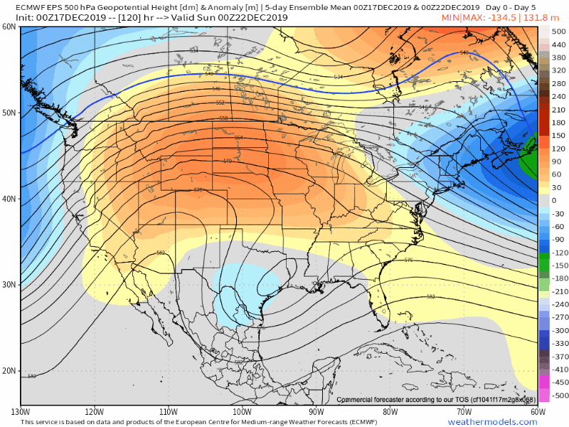
This will do a couple of things: shove the energy that could have led to a weekend East Coast storm south and result in an unusually quiet and mild time of things, locally for the Christmas holiday.

In fact, with the exception of a couple light snow showers in association with Wednesday cold frontal passage, we’re talking about a precipitation-free stretch through Christmas Day. Not only will the active pattern come to an abrupt halt, but temperatures will begin to moderate to well above average levels by Christmas Eve and Christmas Day. Highs around the 50° mark are likely.

The next chance of meaningful precipitation just come just after Christmas and likely take the form of rain.

Permanent link to this article: https://indywx.com/2019/12/17/looking-ahead-to-christmas-week-quiet-warmer-than-average/

Client Brief: Heavy Snow Bands Return Into The Overnight…

Type: Impactful Wintry Weather

This evening’s mesoscale analysis reflects a blossoming area of snow across MO into IL that will move east across central Indiana during the overnight.

What: Accumulating snow; mixed wintry precipitation

When: This evening into Tuesday morning

Temperatures: Lower to middle 30s, falling into the middle 20s Tuesday morning

Wind: Northeast shifting to the northwest Tuesday morning

Blowing/ Drifting: Minimal

Pavement Impacts: Plowing and salting will be required.

Our ongoing snowfall forecast from last night remains unchanged. Please note these are storm total snowfall amounts by Tuesday morning.

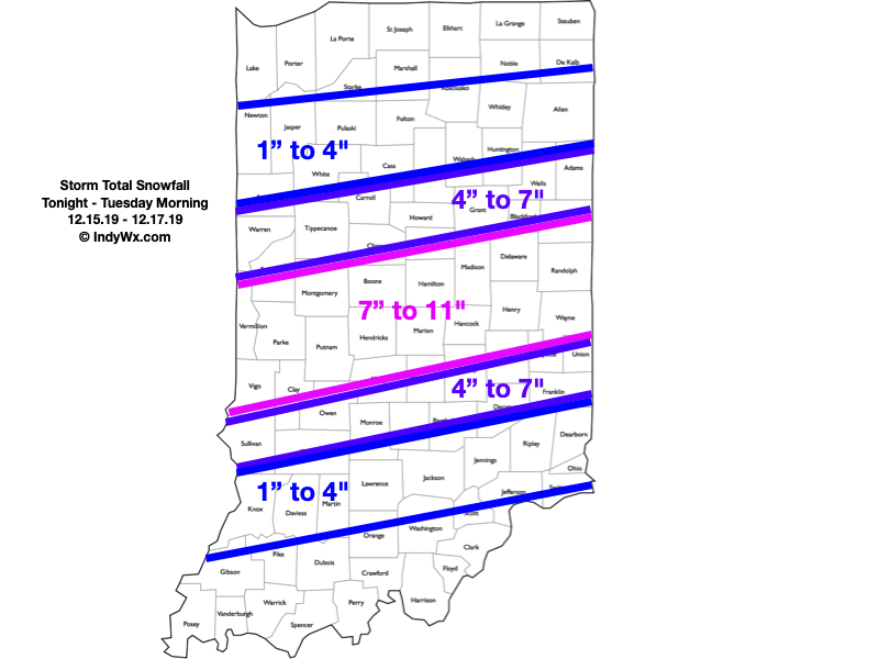
“Round 2″ is underway and we actually believe the overall snow shield will become more expansive with time through the late evening and overnight hours. Within this growing snow shield, embedded banding is expected that will include moderate to heavy snowfall rates. This continues to look like an I-70 special with respect to heaviest totals (7″ to 11″ range for storm totals). On either side of that heaviest snow zone, 4″ to 7” can be expected. On the north side, this is due to lighter intensity of snow (both with Part 1 and Part 2) and mixing issues on the south side.

Snow will exit the city just before daybreak, and southeast Indiana between 8a and 9a. Winds will shift to the northwest and an overall colder day is expected Tuesday, but at least we won’t have to worry about additional snow once past daybreak.

Cold air reinforcements will blow into town Wednesday with a couple snow showers across east-central Indiana. The bigger deal will be the cold, including temperatures that will remain stuck in the middle 20s through the daytime hours. Add in a stiff breeze and wind chill values will be in the 10s.

Confidence: High

Next Update: Tuesday morning

Permanent link to this article: https://indywx.com/2019/12/16/client-brief-heavy-snow-bands-return-into-the-overnight/

VIDEO: Heavy Snow Returns This Afternoon; Intense Banding Expected…

You must be logged in to view this content. Click Here to become a member of IndyWX.com for full access.  Already a member of IndyWx.com All-Access?  Log-in here.

Permanent link to this article: https://indywx.com/2019/12/16/video-heavy-snow-returns-this-afternoon-intense-banding-expected/

IndyWx.com