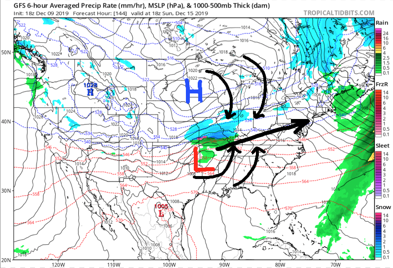
Our December thoughts remain unchanged, and the increasingly active 2nd half of the month will provide challenges. This is in the face of what should still be a relatively mild pattern- or only marginally cold for the most part. This is likely the beginning of the transition towards more sustained cold, wintry times as 2020 gets underway, but there will be a big fight in the midst of the transition.
The first challenge awaits late in the weekend and early next week and today’s model data is in more agreement with the handling of a set of features that may produce a stripe of accumulating snow from the central Plains into the Ohio Valley during the aforementioned time period.
The set-up is one that should feature a surface wave develop in the central Plains (likely TX/ OK panhandle) Saturday afternoon. From there the wave of low pressure will scoot across Arkansas and into the lower Ohio Valley. There are some intriguing details present with this system that have been missing from other systems we’ve seen from late fall into the early portions of meteorological winter: 1.) Timing of the system with at least marginally cold air drilling in behind departing EC system. 2.) Position of the surface high funneling cold air into the system (as opposed to departing as the system arrives). 3.) Overall modeled favorable track.
Now, there are obviously some questions remaining that will have to be answered in the days ahead (always the case when a feature is 6-7 days away), but it’s most certainly something to keep close tabs on as we move forward. As things stand now, I’d monitor the Sunday-Monday time frame for possible wintry impacts across central Indiana.
This has our attention and subsequent updates will follow as we move forward.

