January 2020 archive

Time To Beat The Drum A Little Louder On Next Week?

After a surge of warmth engulfs the region during the early part of the week, a cold front will sag south into the central Ohio Valley Tuesday night into Wednesday.

An upper level ridge will provide a brief taste of spring to open the week.

This front will result in an expanding shield of rain Monday night into Tuesday across all of central Indiana.

Rain will increase across the area Monday evening.

As we progress through Tuesday evening, the frontal boundary will likely sag south, allowing colder air to filter in (at least at the lowest levels of the atmosphere) across north-central parts of the Ohio Valley. As another slug of moisture moves northeast along the frontal boundary, precipitation is expected to once again become widespread Tuesday night into Wednesday. With the colder air oozing in, a mixture of sleet and freezing rain is a possibility across northern IL, IN, and OH. The precise placement of the front will determine whether or not more of central Indiana can get in on the “excitement” of this icy mixture during the aforementioned time period.

It’ll be wise to pay attention to forecast details during the weekend for the Tuesday and Wednesday time period- especially if you have travel plans north.

As this takes place, the upper ridge will get “beaten back” into the 2nd half of the work week. It’s important to note, however, that there will likely still be enough resistance from the upper level ridge that the cold front will get hung up along or just east of the spine of the Appalachians in the Thursday-Friday time frame.

As this transpires, yet another wave of energy will move up along the pressing boundary. Accordingly, precipitation should once again blossom in response of this wave of low pressure moving northeast. While the European (shown below) wants to keep things east of the immediate region, it’s wise not to write this system off from this distance. Not only does other data show the threat locally, but it’s all too often where storm systems “correct” further west as time draws closer to said event…

While this week has been relatively boring in the weather department, things will change in significant fashion next week. Whether or not those changes can deliver “wintry goods” is TBD…

Stay tuned.

Permanent link to this article: https://indywx.com/2020/01/31/time-to-beat-the-drum-a-little-louder-on-next-week/

January Review; Looking Ahead To A Busy Week In Front Of Us…

You must be logged in to view this content. Click Here to become a member of IndyWX.com for full access.  Already a member of IndyWx.com All-Access?  Log-in here.

Permanent link to this article: https://indywx.com/2020/01/31/january-review-looking-ahead-to-a-busy-week-in-front-of-us/

VIDEO: More Active Times On The Horizon…

You must be logged in to view this content. Click Here to become a member of IndyWX.com for full access.  Already a member of IndyWx.com All-Access?  Log-in here.

Permanent link to this article: https://indywx.com/2020/01/30/video-more-active-times-on-the-horizon/

Things Turn More Active Early Next Week…

The short-term weather pattern will remain largely uneventful here across central Indiana. This morning, widespread precipitation is falling to our southwest, including accumulating snow across MO. This system will weaken significantly as it pushes east.

Some upper level energy is still capable of developing some light snow across central Indiana tonight into Thursday morning, but this won’t be a big deal and some neighborhoods won’t see any snow at all.

A ribbon of upper level energy will move across the state tonight.

An additional upper level disturbance will track southeast, skirting far northeastern parts of the area, and help generate a mixed rain or snow shower Saturday (again, not expected to be a big deal, locally).

Behind this system, a significant warm up will engulf the Ohio Valley, including a couple of days with highs between 50° and 55° early next week.

These spring-like temperatures will be in advance of a pressing cold front that will arrive on the scene during the middle part of the work week. As we’d imagine from this distance, modeling is handling the timing and specifics of the frontal system differently (image 1- GFS is more progressive and colder while image 2-the European is much slower/ warmer). We’ll take the next couple of days to sort through the details and have a higher level of confidence going into the weekend.

We’ll also have our February Outlook posted here tomorrow as part of Thursday’s long range video update.

Permanent link to this article: https://indywx.com/2020/01/29/things-turn-more-active-early-next-week/

VIDEO: Light Snow Chances In The Short-Term; Weekend Discussion, And Looking Ahead To A Strong Cold Front Next Week…

You must be logged in to view this content. Click Here to become a member of IndyWX.com for full access.  Already a member of IndyWx.com All-Access?  Log-in here.

Permanent link to this article: https://indywx.com/2020/01/28/video-light-snow-chances-in-the-short-term-weekend-discussion-and-looking-ahead-to-a-strong-cold-front-next-week/

Week-Ahead Outlook And Early February Thoughts…

You must be logged in to view this content. Click Here to become a member of IndyWX.com for full access.  Already a member of IndyWx.com All-Access?  Log-in here.

Permanent link to this article: https://indywx.com/2020/01/27/week-ahead-outlook-and-early-february-thoughts/

VIDEO: Reasons To Buy Into The Colder Change Early February…

You must be logged in to view this content. Click Here to become a member of IndyWX.com for full access.  Already a member of IndyWx.com All-Access?  Log-in here.

Permanent link to this article: https://indywx.com/2020/01/26/video-reasons-to-buy-into-the-colder-change-early-february/

VIDEO: Talking Saturday Snow Accumulation; Looking Ahead To Another Busy Week…

You must be logged in to view this content. Click Here to become a member of IndyWX.com for full access.  Already a member of IndyWx.com All-Access?  Log-in here.

Permanent link to this article: https://indywx.com/2020/01/25/video-talking-saturday-snow-accumulation-looking-ahead-to-another-busy-week/

Today’s Rain Gives Way To Saturday Snow…

A big upper level low will “pinwheel” across the state later this evening. On the front end of the system, a southerly flow will deliver periods of rain today. At times, rain will take on a steadier nature and at others, only light rain and drizzle is anticipated.

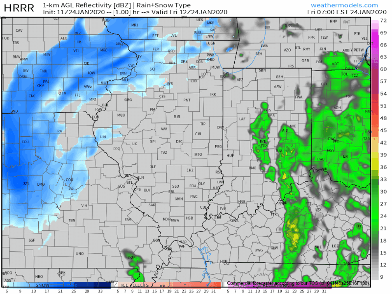
Heaviest rainfall will occur across the eastern third of the state, including amounts around 0.50″.

As the upper low continues to track northeast, we’ll get in on the northerly flow of this feature tonight into Saturday. Secondly, a lobe of moisture will pivot into central and northern Indiana Saturday morning. With the colder air in place, the bulk of this should fall in the form of snow.

We think snow will move into the area around, or just before, sunrise Saturday and remain through the bulk of the day. Periods of moderate snow will fall with embedded bands, especially across north-central Indiana.

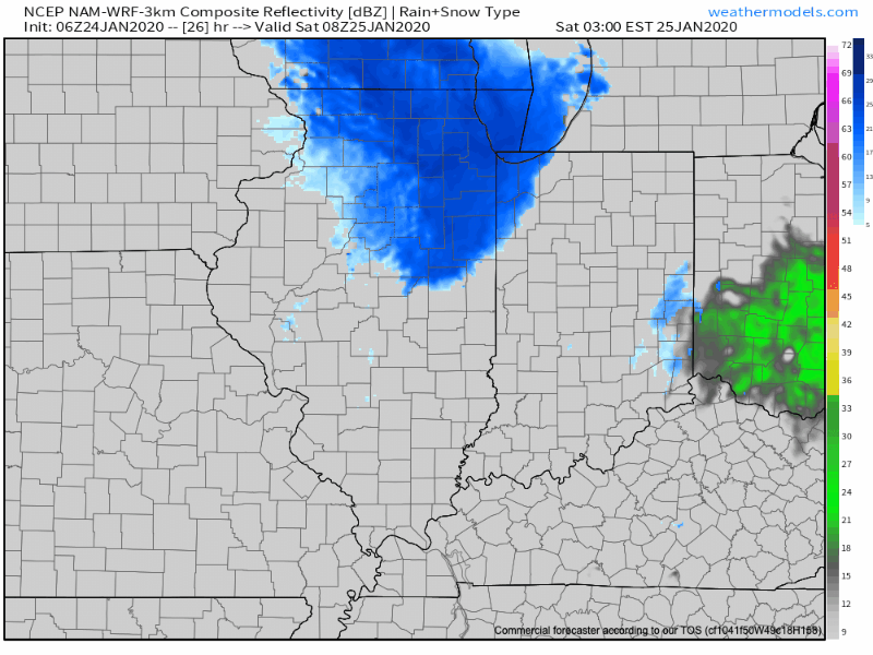
As for accumulation Saturday, we think in and around Indianapolis can expect a coating to up to 1″ of wet, slushy snow Saturday (no impacts to pavement expected). Northern suburbs (Zionsville, Carmel, Noblesville, etc.) and points north can expect 1″ to 2″ Saturday with the potential of slushy accumulation on untreated pavement surfaces.

The snow will depart Saturday night and we’ll get back to dry conditions Sunday.

Permanent link to this article: https://indywx.com/2020/01/24/todays-rain-gives-way-to-saturday-snow/

Short-Term Update On Saturday’s Snow; Long Range Look Into February…

You must be logged in to view this content. Click Here to become a member of IndyWX.com for full access.  Already a member of IndyWx.com All-Access?  Log-in here.

Permanent link to this article: https://indywx.com/2020/01/23/short-term-update-on-saturdays-snow-long-range-look-into-february/

IndyWx.com