January 2020 archive

VIDEO: Timing The Arrival Of Precipitation Friday; MUCH Colder Air Moves In…

You must be logged in to view this content. Click Here to become a member of IndyWX.com for full access.  Already a member of IndyWx.com All-Access?  Log-in here.

Permanent link to this article: https://indywx.com/2020/01/16/video-timing-the-arrival-of-precipitation-friday-much-colder-air-moves-in/

First Comes The Cold, Then Come The Storms…

You must be logged in to view this content. Click Here to become a member of IndyWX.com for full access.  Already a member of IndyWx.com All-Access?  Log-in here.

Permanent link to this article: https://indywx.com/2020/01/15/first-comes-the-cold-then-come-the-storms/

VIDEO: Late Week Storm; Much Colder Next Week…

You must be logged in to view this content. Click Here to become a member of IndyWX.com for full access.  Already a member of IndyWx.com All-Access?  Log-in here.

Permanent link to this article: https://indywx.com/2020/01/15/video-late-week-storm-much-colder-next-week/

VIDEO: Friday-Saturday Storm; Leaning On The MJO In The Long Range…

You must be logged in to view this content. Click Here to become a member of IndyWX.com for full access.  Already a member of IndyWx.com All-Access?  Log-in here.

Permanent link to this article: https://indywx.com/2020/01/14/video-friday-saturday-storm-leaning-on-the-mjo-in-the-long-range/

Tuesday Morning Rambles: Weak Midweek System Followed By Another Strong Late Week Storm…

1.) Patchy fog will burn off to another day with mostly cloudy conditions (should see a bit more sunshine than we saw on Monday) and mild temperatures. Mid 30s will warm into the lower 50s today and middle 50s Wednesday. The downside to Wednesday’s mild air? Light rain will scoot across the state. “Light” is the key word with amounts of a trace to under 0.10″.

Light rain will move across Indiana Wednesday.
Rainfall amounts of only 0.05″ to 0.10″ can be expected Wednesday.

2.) A cold front will push south across the region Wednesday evening and result in colder conditions (but with increased sunshine) Thursday. Highs in the lower to middle 30s can be expected across central Indiana Thursday.

3.) As we move into late week, a stronger storm system will impact the area. Low pressure will develop along the lee of the Rockies Friday morning before tracking into the lower Great Lakes Saturday morning and into New England Sunday. With marginally cold air in place Friday (courtesy of Wednesday evening’s cold front), “overrunning” precipitation should fall as a wintry mix of snow and sleet Friday afternoon. While still early, it’s possible a quick couple inches of snow and sleet make travel messy Friday PM (worth keeping a close eye on) before precipitation changes to a cold rain Friday night into the predawn Saturday. Eventually, as the cold front whips across the state, colder air will return Saturday morning and precipitation will end as snow showers.

Snow and a wintry mix, including sleet will move into central Indiana Friday afternoon.

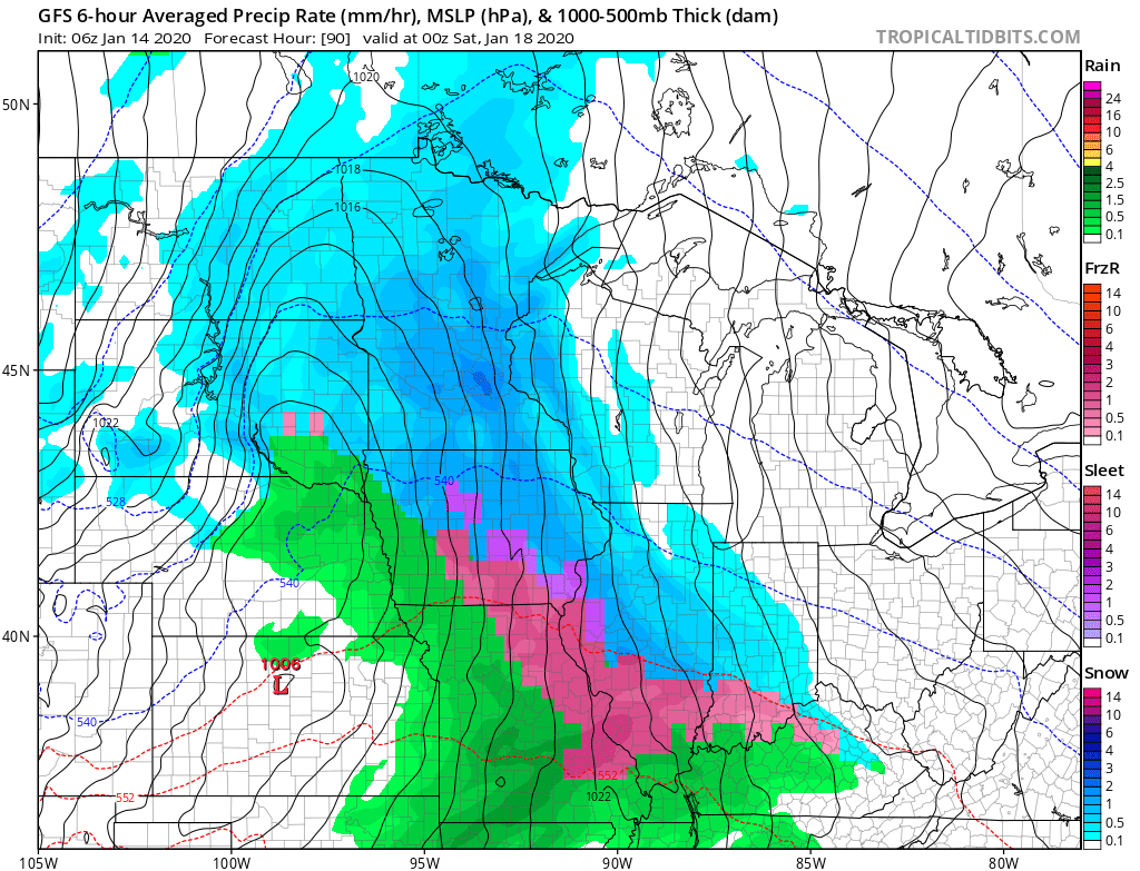
4.) The previously mentioned storm system will usher more of a prolonged wintry pattern back into the eastern portion of the country. As we look ahead through the remainder of the month, below normal temperatures are expected to carry the day, along with the threat of additional wintry precipitation from time to time. This is the kind of pattern that will certainly promote storms and “rumors of storms” and it’ll be important to remain locked into the forecast as we put a close on January.

Permanent link to this article: https://indywx.com/2020/01/14/tuesday-morning-rambles-weak-midweek-system-followed-by-another-strong-late-week-storm/

VIDEO: Relatively Quiet Open To The Work Week; Big “Problematic” Late Week Storm…

You must be logged in to view this content. Click Here to become a member of IndyWX.com for full access.  Already a member of IndyWx.com All-Access?  Log-in here.

Permanent link to this article: https://indywx.com/2020/01/13/video-relatively-quiet-open-to-the-work-week-big-problematic-late-week-storm/

VIDEO: Week-Ahead Outlook And More On The Pending Pattern Change…

You must be logged in to view this content. Click Here to become a member of IndyWX.com for full access.  Already a member of IndyWx.com All-Access?  Log-in here.

Permanent link to this article: https://indywx.com/2020/01/12/video-week-ahead-outlook-and-more-on-the-pending-pattern-change/

VIDEO: Short-Term Update And More On Winter’s Return…

You must be logged in to view this content. Click Here to become a member of IndyWX.com for full access.  Already a member of IndyWx.com All-Access?  Log-in here.

Permanent link to this article: https://indywx.com/2020/01/11/video-short-term-update-and-more-on-winters-return/

Client Brief: Heavy Rain Increases Flood Potential Into The Weekend; Strong Wind Also A Concern…

Type: Heavy Rain & Strong Winds

What: Localized flood potential 

When: Friday and Saturday

Rain Amounts: 2.5″ to 3.5″ (localized heavier totals)

Wind: Variable 20-30 MPH with gusts to 50 MPH+ Saturday

Periods of moderate to heavy rain developed during the overnight and continue as we type this client brief this morning. Rain will continue for a good portion of today into tonight (locally heavy at times) before we likely go through a break in the rain early Saturday morning. That lull in the action won’t last long as rain is quickly expected to return by late morning and continue through the afternoon, into the early evening hours. What will already be a windy day today (30-40 MPH gusts) will only grow worse Saturday with some 50 MPH gusts a good bet.

As the surface low moves to our northeast, a cold front will sweep through the state Saturday evening and shut off the rain. Cooler air will move in to close the weekend.

Modeled forecast rainfall totals by 8p Saturday

Confidence: High

Next Update: Friday evening

Permanent link to this article: https://indywx.com/2020/01/10/client-brief-heavy-rain-increases-flood-concerns-into-the-weekend-strong-wind-also-a-concern/

Once A Foe Becomes An Ally: Reasons As To Why Winter Not Only Returns, But Locks-In…

With a full week now in the books, January has opened much warmer than average from the northern Plains into the eastern portion of the country. Widespread anomalies of 10° to 15° above average dominate from the northern Plains into the Southeast.

However, behind the scenes, significant changes are afoot that will likely deliver a drastically different weather pattern into the Lower 48 around and after the 20th. (Next week will begin the colder transition, but it’s not until the 20th and beyond we think the cold has more staying power).

You know we’ve put all of our eggs in the MJO/ EPO basket through at least mid-February. After that point, it’ll be prudent to additionally pay attention to the NAO and AO.

We note the MJO is set to rumble out of the warm phases and towards much colder phases around and after the middle part of the month. The amplitude of this movement suggests a rather rude shock may await…

Phase 5 is, obviously, a blow torch across the East, but things begin to trend colder through Phase 6 and more substantially so by Phase 7.

On the composites above, note the way high latitude blocking gets established and matures during the transition through Phase 6-7.

(There are reasons to believe this amplitude will continue, taking things into Phases 8,1, and 2 as we close January and head into February). Just for fun, here’s what Phase 8 should produce:

A large part of the reason behind thinking winter “locks-in” has to do with what we think will likely be the MJO making a trip through Phases 1,2, and 3 as we open February.

For those interested in the 500mb pattern through those phases (during the month of February), here you go:

It’s not just the MJO that’s set to push winter back into the region, but the EPO, as well. Note the GEFS and EPS in good agreement developing a negative EPO as we push past the middle of January:

One can argue as to the drivers behind what we think will be a colder (and eventually significantly so) shift in the pattern, but a big reason in our minds has to do with the sea surface temperature (SST) configuration. As the winter pattern matures, we think it really was only a matter of time before the analog research (from way back in the summer) began to pay off.

Out of all of the various modeling out there, I think the JMA Weeklies show how things will likely play out best over the next 2-3 weeks. Note the significant changes between this week (image 1) and the Weeks 3-4 (image 2) time period. Cold is set to begin overwhelming the pattern, but with what should still be an active storm track with resistance from the southeast ridge. This would lead to a continued active pattern with the expanding cold.

Fun times ahead. Stay tuned…

Permanent link to this article: https://indywx.com/2020/01/09/once-a-foe-becomes-an-ally-reasons-as-to-why-winter-not-only-returns-but-locks-in/

IndyWx.com