Category: Unseasonably Warm
 Highlights:
- Western storms
- Hot Labor Day
- MUCH cooler late next week
Thunderstorms will slowly push south this morning, especially across western portions of the state. Many will be asking “what storms?” while others are getting pounded by heavy rain, vivid lightning, small hail, and strong winds. Best chances of getting a storm will be along and west of I-65.
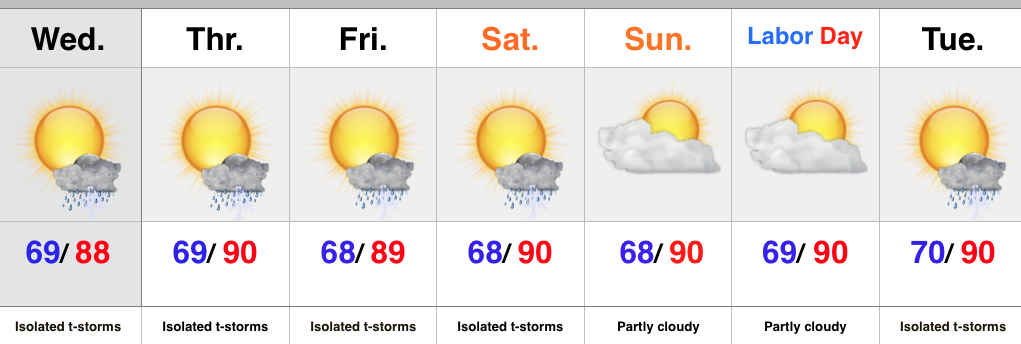
Drier conditions will build in for the second half of the weekend and into early next week. Labor Day will be a very hot and humid one.
Rain and storm chances will increase as we push into the mid week stretch as a strong cold front moves into the Mid West. MUCH cooler air will infiltrate the state late next week and things will be feeling very “fallish” by the weekend.
Upcoming 7-Day Rainfall Forecast: 0.50″-1″ (locally heavier totals)
Permanent link to this article: https://indywx.com/thunderstorms-especially-west/
 Highlights:
- Storm potential north
- Hot Labor Day weekend
- Cold front delivers storms and cooler air next week
We’re off to another steamy one this morning with many neighborhoods already between 65-70 as we type this predawn Friday. We’ll zoom up yet again to around 90 this afternoon with only isolated storm coverage. Better chances of rain and storms can be expected across northeastern portions of the state due to a little “weakness” in the atmosphere.
The story for the long holiday weekend is one of heat and humidity, with little, if any, storm threat (very isolated coverage). Highs Saturday though Monday should reach around 90.
However, changes are coming down the road as a significant cold front sweeps the region Wednesday into Thursday. Showers and thunderstorms will accompany the frontal passage followed by a MUCH cooler, fall-like, air mass arriving by the end of next week.
Upcoming 7-Day Rainfall Forecast: 0.50″ – 1″
Permanent link to this article: https://indywx.com/summer-like-now-but-cooler-times-loom/
 Highlights:
- Hot and humid conditions continue
- Isolated storm coverage
- Cold front approaches next week
In the short term, heat and humidity remain the big weather story as we head into the long Labor Day weekend, and unofficial end of summer. BTW- meteorological summer ended Monday evening; however someone forgot to tell Mother Nature. Isolated storm coverage will be present into the weekend.
The next big weather maker is on the horizon by the middle of next week in the form of a cold front. Much better chances of more widespread showers and thunderstorms should precede the front before a much cooler air mass arrives late next week.
Upcoming 7-Day Rainfall Forecast: 0.50″ – 1″
Permanent link to this article: https://indywx.com/hot-with-isolated-storms/
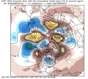
Summer sure doesn’t appear to be letting go anytime soon as our recent 7-day outlook suggests, but there are indications that our unseasonably hot and humid regime may take a back seat to the refreshing taste of fall in about 10 days. The big “tip of the cap” towards the cooler pattern? The PNA, or Pacific North American pattern, shifting from negative to positive. As shown below, both the European (top) and GFS (bottom) highlight the PNA shift to positive.
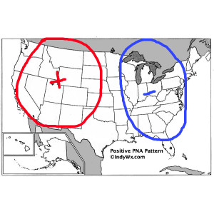
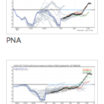 A positive PNA favors eastern troughiness and an associated cooler than normal regime over our neck of the woods.
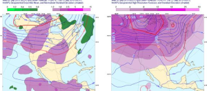
 Sure enough, models are trending towards a much cooler direction for week 2.
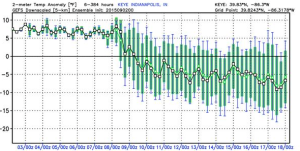 It’ll be fun to watch things unfold. For now, if you’re a fan of summer weather, be sure to enjoy the next week, or so, as things appear to be changing for the much cooler side of things around the 10th (give or take a day or two).
Permanent link to this article: https://indywx.com/cooler-times-ahead-by-mid-month/
 Highlights:
- Isolated slow moving storms
- Hot and humid air mass remains
- Stagnant pattern
An upper level disturbance will push slowly east into Ohio Wednesday, but will remain close enough to have some impact on our local weather. Coverage of storms won’t be as widespread as those of today, but we’ll likely see a few slow moving, strong storms develop across central IN all the same.
We’ll maintain mention of isolated storms into the weekend, but the big weather story will be the unseasonably hot and humid air mass in place. It’s all part of the big weather picture that includes a strengthening high pressure ridge (hot dome) over the Lakes and SE Canada as we rumble into the long holiday weekend.
Looking ahead, there are indications that more active times are around the corner once to mid month.
Upcoming 7-Day Rainfall Forecast: 0.25″ – 0.50″ (locally heavier totals)
Storms rumbled across portions of central IN today, but the “@cryptics cam” caught a glorious sunset from Danville this evening.

Permanent link to this article: https://indywx.com/summer-isnt-letting-go/


