VIDEO: Storm Chances Return And We Look Ahead To Meteorological Fall…
You must be logged in to view this content. Click Here to become a member of IndyWX.com for full access. Already a member of IndyWx.com All-Access? Log-in here.
You must be logged in to view this content. Click Here to become a member of IndyWX.com for full access. Already a member of IndyWx.com All-Access? Log-in here.
 Highlights:
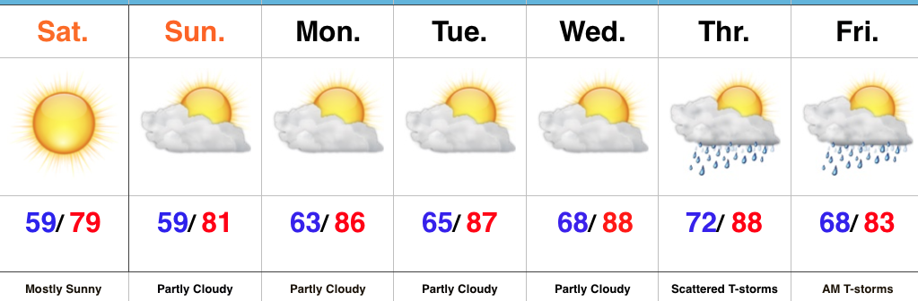
Refreshing Conditions Continue…A cold front settled south of the region last night, allowing drier and slightly cooler air to filter in during the overnight. That sets the stage for the weekend as we can expect dry and refreshing conditions, along with below average temperatures.
Dry skies will continue into the new work week, but humidity will slowly begin to increase once we get to midweek. A southwesterly air flow will develop ahead of our next storm system that will deliver scattered thunderstorms by Thursday. Shower and thunderstorm chances will continue Friday morning, however, early indications suggest next weekend is also dry.
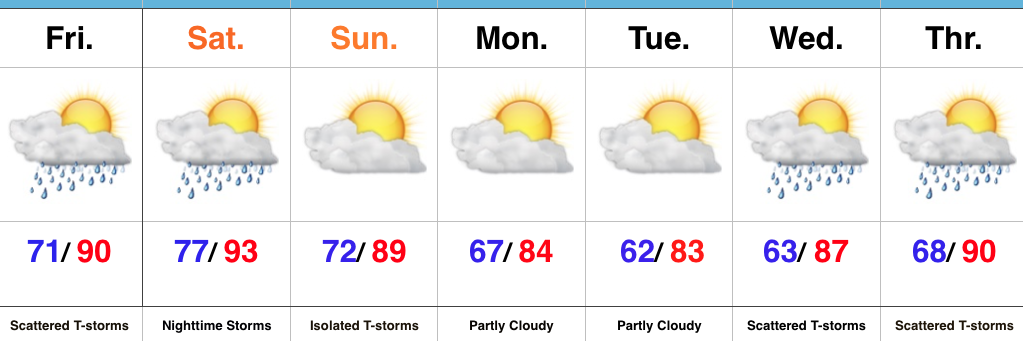
Upcoming 7-Day Precipitation Forecast:
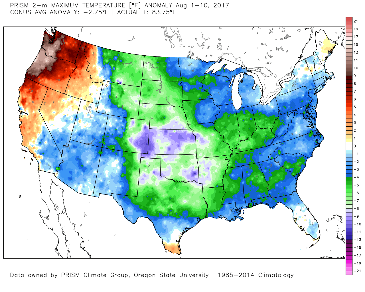
Cool August: The month has opened impressively cool with a CONUS average anomaly of – 2.75° through the 10th. More specifically to Indianapolis, we’re running 3° below normal through the 11th.
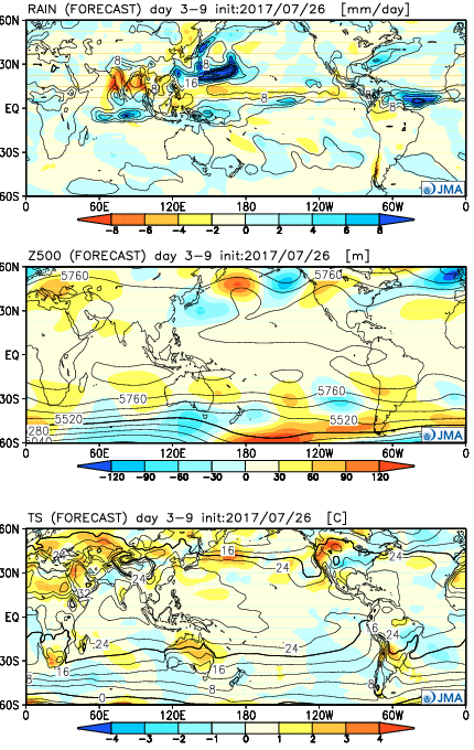
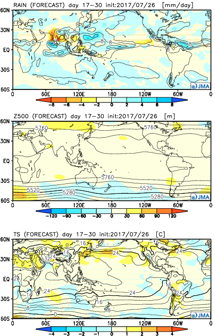
The new JMA Weeklies are in and highlighted by the following:
Week 1:
A trough will sink into the central and eastern portions of the country and result in rather widespread below normal and quite refreshing conditions as we close the month of July. Along with the cool, dry air will come an extended stretch of rain-free conditions through the latter portions of next week.
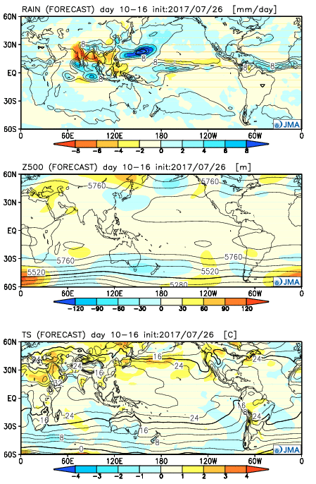
 Week 2:
The JMA suggests the mean trough position will remain across the central portions of the country with signals of ridging developing along the Northwest coast. Cool, wet weather (compared to average) is forecast central as the heat continues across the West. We also note developing warmth across the Northeast region.
 Weeks 3-4:
Seasonal temperatures are set to unfold across the central late August with warmest anomalies painting themselves across the Northeast and Northwest portions of the country. The pattern, locally, is set to become more active from a precipitation perspective as wet conditions return.
You must be logged in to view this content. Click Here to become a member of IndyWX.com for full access. Already a member of IndyWx.com All-Access? Log-in here.
 Highlights:
Mother Nature Calls…Many awoke early this morning as a complex of thunderstorms rumbled southeast into central Indiana. Some local rain gauges are already registering 2″+ across the region. Eventually, we think clouds will thin enough later today to allow temperatures to zoom close to 90°. Factor in the moisture-rich nature of our air mass and heat indices will approach 105° later this afternoon.
We’ll keep mention of scattered storms this evening and while most of the daytime Saturday looks dry, we’ll have to keep a close eye on Saturday night as models try to deliver another round of storms into central Indiana. Ingredients will be in place for the potential of severe thunderstorms Saturday night, with damaging winds being the biggest concern from a severe perspective.
A frontal boundary will push south and we’ll finally begin to see humidity levels fall as we close the weekend and open next week. It’ll feel very refreshing during the Monday-Tuesday stretch.
Heat, humidity, and storm chances return by the middle of next week.
Upcoming 7-Day Precipitation Forecast: