VIDEO: Hurricane Irma And Warmer Times Loom…
You must be logged in to view this content. Click Here to become a member of IndyWX.com for full access. Already a member of IndyWx.com All-Access? Log-in here.
You must be logged in to view this content. Click Here to become a member of IndyWX.com for full access. Already a member of IndyWx.com All-Access? Log-in here.
August, month-to-date, is running bone-dry. Officially, IND has only accumulated 0.18″ of rain, but that may be changing as early as this afternoon and evening.
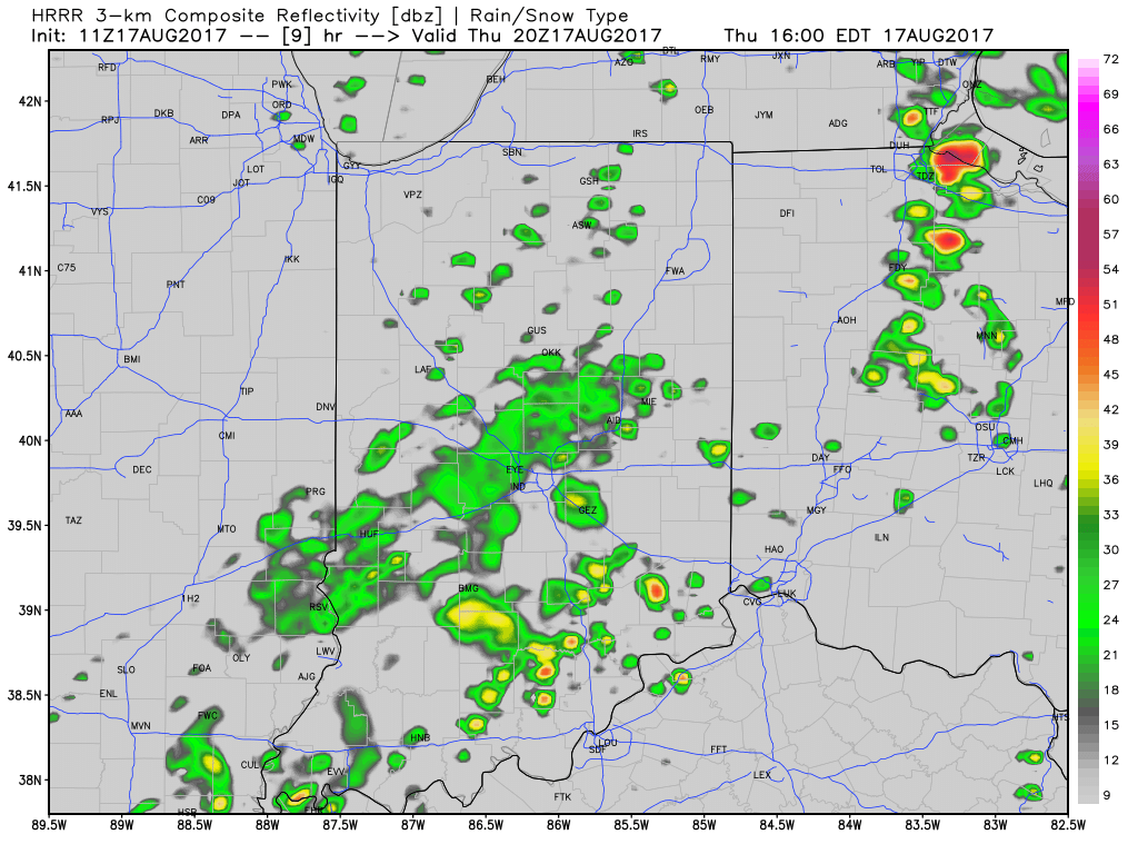
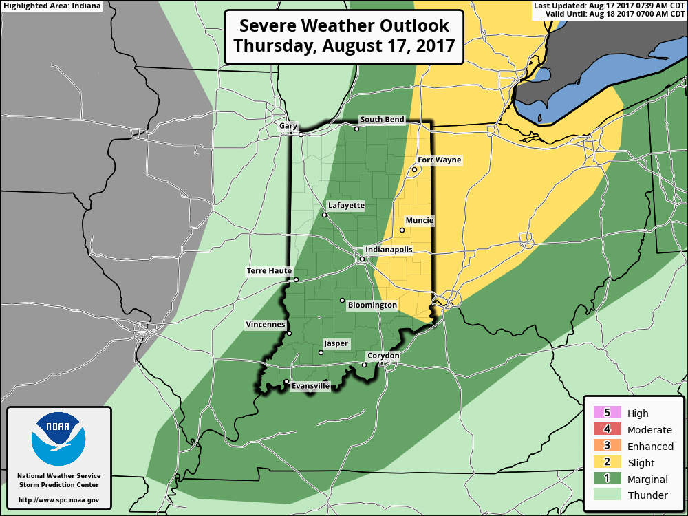
We note high resolution, short-term data is becoming more aggressive with the development of showers and thunderstorms this afternoon and evening. Initially, storms will impact w-central parts of the state before encompassing more of central Indiana. The following are images of what the local radar may look like at 4p, 6p, and 8p.
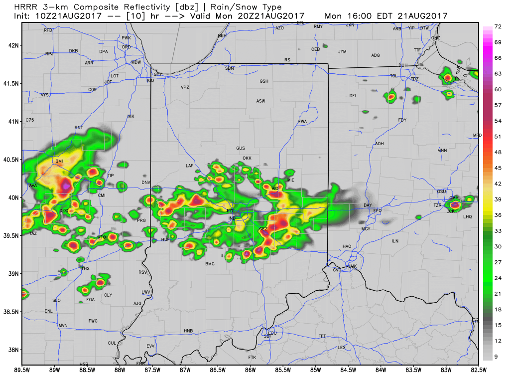
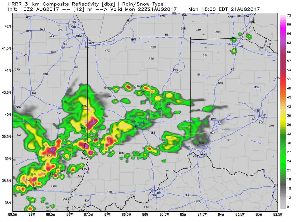
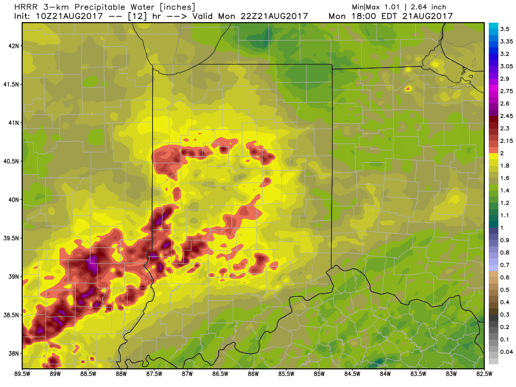
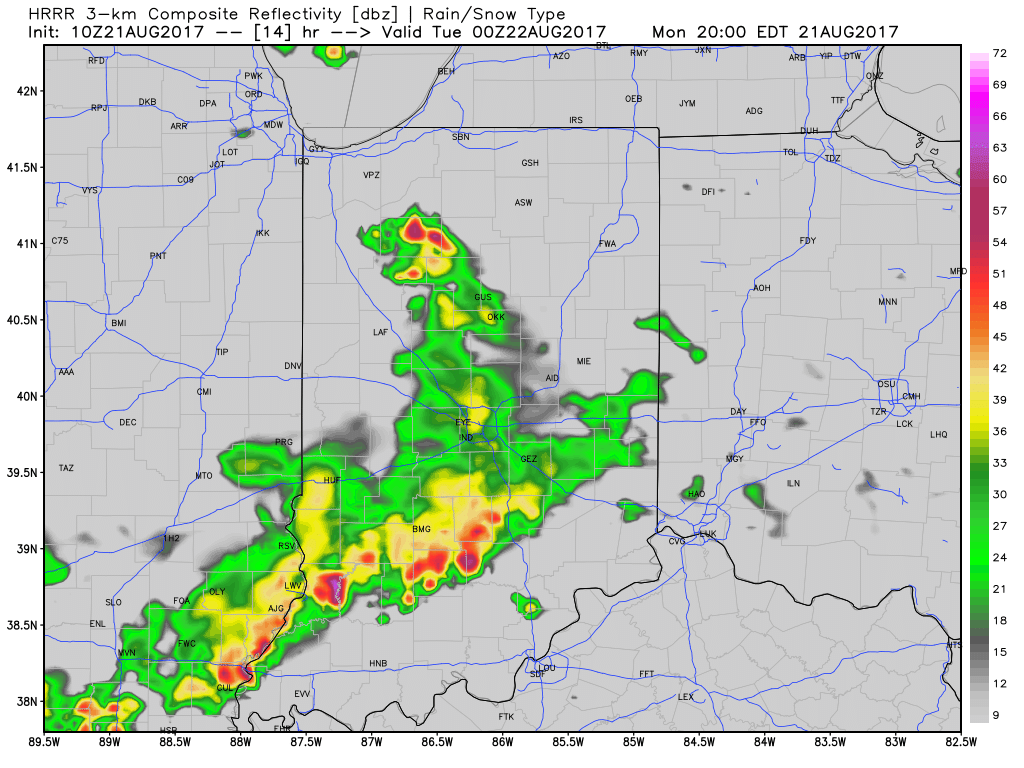 With leftover boundaries from early morning storms across northern parts of the state (likely will serve as a “trigger” for PM storm development), combined with a hot and muggy airmass, confidence is increasing on numerous showers and thunderstorms across central Indiana this afternoon and evening. Widespread heavy rain isn’t expected this afternoon, but localized hefty downpours are a good bet with precipitable water values (PWATs) approaching 2″ this afternoon.
 Unsettled times remain Tuesday before a much cooler regime looms for the second half of the week…
 Highlights:
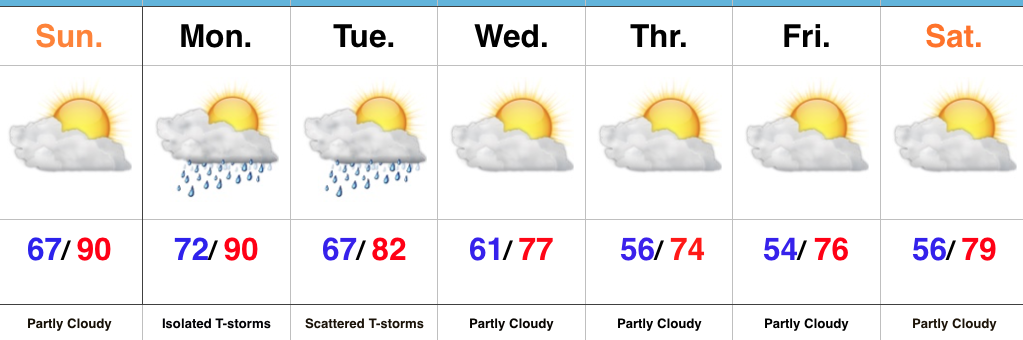
Time To Sweat…A hot and increasingly humid airmass will be with us as we open a new week. While most of the upcoming 24-48 hours will remain rain-free, we will mention chances of an isolated to widely scattered thunderstorm Monday. Most will remain free of rain and storms, but those lucky folks who do find themselves under a storm Monday can expect to pick up a quick 1″ of rain. Better overall coverage of showers and thunderstorms will develop late Monday night into Tuesday.
Typically, a pattern change such as what we’ll undergo this week (summer-like to early fall-like) would yield widespread showers and thunderstorms. However, a look at short-term, higher resolution data isn’t particularly “excited” about widespread significant rainfall across central Indiana. We expect a weakening complex of thunderstorms off to our northwest to drift southeast Monday night. Depending on how quickly this complex weakens will determine rainfall amounts, locally. Additionally, it’s very possible this weakening storm complex will serve to limit new thunderstorm development Tuesday as the cold front moves closer. We do note high resolution data places emphasis on northern and southern parts of the state for heaviest rains and it’s tough to disagree with that idea given what we’re looking at right now. Stay tuned.
Regardless of the rain and storm situation, locally, we’ll all turn significantly cooler by midweek. In fact, temperatures will grow cool enough to feel like mid-September. Dry conditions will carry us into next weekend.
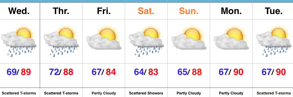
Upcoming 7-Day Precipitation Forecast:
I. A cold front will move across the state this evening. Ahead of the front, a warm and moist air mass will remain in place and the frontal boundary will serve as a “trigger” to ignite scattered to numerous showers and thunderstorms, especially this afternoon and evening. While widespread, uniform rains aren’t anticipated, a couple of strong storms and localized downpours will develop ahead of the front.
II. After a drier close to the work week (less humid, as well), an upper level disturbance will race across the Ohio Valley Saturday. This will provide enough lift to generate scattered showers and thunderstorms across the region, but all day rains won’t occur.
 III. Ridging will return early next week and, though brief, a shot of late-summer heat will eject northeast across the Mid West and Ohio Valley. Sunday through Tuesday will feature temperatures that top out in the upper 80s to around 90°.
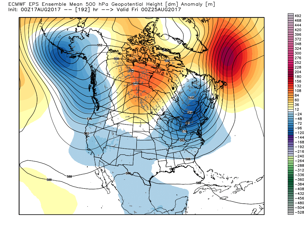
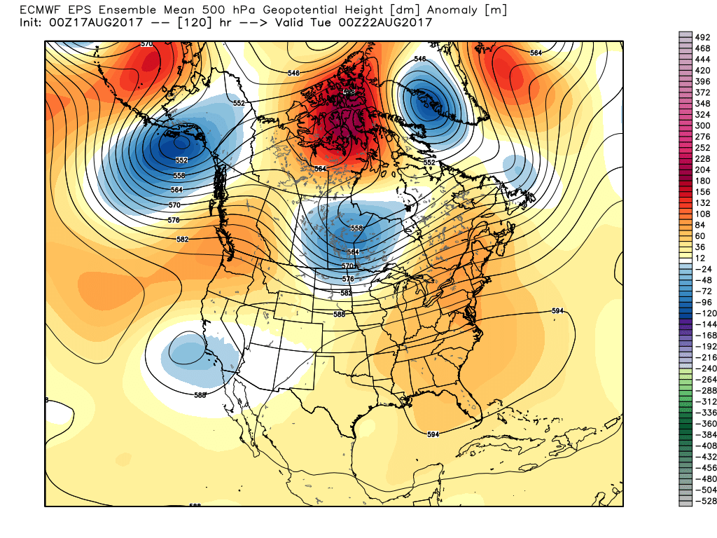 IV. A cold front will drop in by the middle of next week. Scattered showers and thunderstorms will accompany the frontal boundary, but the bigger story will be a dramatic change to a much cooler regime as we get set to put a wrap on the month of August. In fact, temperatures may grow cool enough to allow some 40s to develop across central and northern parts of the state at night. Meteorological summer sure looks like it’ll end with more of a fall-like feel…
 Highlights:
More Dry Time Than Stormy…A warm and moist southwesterly air flow will have things feeling quite muggy today. This tropical feel will also help fuel scattered thunderstorms by evening, continuing into tonight. While everyone won’t get wet today, those that do have the potential of picking up a quick 1″ in a short period of time. A cold front will cross the state Thursday and will keep scattered showers and thunderstorms going. While this isn’t a uniform soaking, we’ll take what we can get as things have been bone dry around these parts lately.
After a quiet and slightly cooler Friday, an upper level disturbance will deliver another round of showers and embedded thunderstorms Saturday. Dry weather will return to wrap up the weekend Sunday.
Looking ahead, a surge of heat, albeit brief, will have things feeling quite toasty around the Mid West early next week. We think we flirt with, or exceed, the 90° mark both Monday and Tuesday. Thunderstorms will increase Tuesday as a cold front drops in from the northwest. Behind the front, data still paints a much cooler regime for the second half of next week; fall-like!
Upcoming 7-Day Precipitation Forecast: