Category: Unseasonably Warm

Turning Colder After A Wet Open To The Week…

screen-shot-2017-01-01-at-7-25-02-pmHighlights:

  • Unsettled open to the week
  • Turning colder Tuesday
  • Couple snow chances, but low confidence

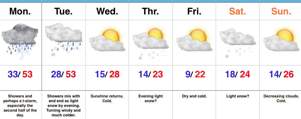
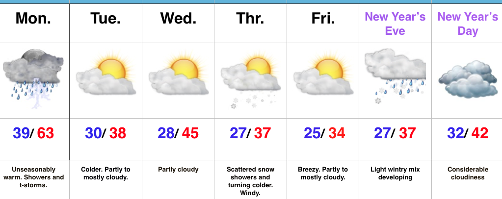
Wet Open To The Week…Clouds waited to increase until after sunset Sunday and the more than expected sunshine led to a downright beauty of a kickoff to 2017, complete with mild temperatures.  Unfortunately, those pleasant conditions won’t last as we deal with increasing coverage of showers and perhaps a thunderstorm Monday.  Rain coverage appears greatest during the evening into the nighttime hours.

An arctic cold front will sweep through the state Tuesday afternoon and lead to a dramatic temperature plunge for the rest of the week.  Showers Tuesday will end as a touch of wet snow before precipitation moves out.

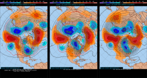
Forecast models are still struggling with handling Pacific energy for mid and late week.  This is leading to a lower than normal confidence level with two potential systems Thursday and again Saturday.  For now, we’re eyeing the threat of light snow with both and believe modeling will come around to more of a weather maker once time draws closer.  Stay tuned.  Cold weather remains as we progress through next weekend.

Upcoming 7-Day Precipitation Forecast:

  • Snowfall: 1″ – 3″
  • Rainfall: 0.50″ – 1.00″

Permanent link to this article: https://indywx.com/turning-colder-after-a-wet-open-to-the-week/

Busy 7-Day To Usher In 2017…

screen-shot-2016-12-30-at-7-18-25-pmHighlights:

  • Raw New Year’s Eve
  • Briefly milder Monday with showers
  • Snow prospects mid week

Busy Times…Clouds will increase late tonight and give way to showers during the daytime New Year’s Eve.  Most of this shower activity will be light, but you’ll want to carry the rain gear with you as you leave for New Year’s Eve parties and celebrations throughout central IN.  Once to the nighttime hours, showers should diminish and most of the nighttime should feature rain-free conditions, along with colder temperatures.

New Year’s Day may start out with some sunshine, but clouds will increase through the day and drizzle or light rain is possible by evening.  Low pressure will track northeast from the central Plains into the upper Mid West Monday.  This will place Indiana in a relatively warm southwest flow.  Periods of showers can be expected through the day, along with breezy conditions.  An accompanying cold front will sweep through the state early Tuesday morning and shut rain chances off, shift winds to the northwest, and lead to falling temperatures.

Wednesday will be a day in between storm systems.  Cold high pressure will settle into the Ohio Valley and supply unseasonably chilly temperatures, but with sunshine.

Our next storm system will approach Thursday.  Clouds will increase Wednesday night and give way to an expanding snow shield during the day Thursday.  We still have a few days to look at things, but from this distance, the potential is present for an impactful wintry event across a widespread portion of the Ohio Valley, including central Indiana.  Stay tuned.  Fresh arctic air will move in to put a close on yet another short work week.

Upcoming 7-Day Precipitation Forecast:

Snowfall: 1″ – 3″

Rainfall:  0.75″ – 1.25″

Permanent link to this article: https://indywx.com/busy-7-day-to-usher-in-2017/

Unseasonably Warm; Wet Day After Christmas…

screen-shot-2016-12-26-at-8-33-12-amHighlights:

  • Unseasonably warm today
  • Showers and perhaps a t-storm by lunchtime
  • Turning more seasonable later this week

Wet At Times Today…A cold front will push across the state later this afternoon.  Ahead of the front, a warm southwesterly air flow will lead to a spring-like feel on this day after Christmas.  Coverage of showers will increase by late morning and around lunchtime, including the possibility of an embedded thunderstorm.  Once the front sweeps through the region, our winds will flip to the northwest and result in a cooler feel as early as tonight.  Tuesday will feature much more seasonable conditions.

Reinforcing chilly air will blow into town Thursday afternoon and with enough upper level energy around, we’ll mention scattered snow showers in our forecast.  Colder weather will be with us to close the week and head into New Year’s weekend.

Speaking of New Year’s, we still eye a storm system around New Year’s Eve.  Confidence is low in the overall set-up in regards to storm track and timing and fine tuning will be required.  For now, we’ll simply go with a developing light wintry mix Saturday and “sure up” the details later this week.

Upcoming 7-Day Precipitation Forecast:

  • Snowfall: Dusting
  • Rainfall: 0.50″ – 0.75″

Permanent link to this article: https://indywx.com/unseasonably-warm-wet-day-after-christmas/

Changeable Weather Christmas To New Years…

It’s hard to believe we’re only a few days from Christmas!  Through the 22nd, Indianapolis is running a whopping 6 degrees below average.  Cold rules across the Lower 48, month-to-date.

ncep_cfsr_noram_t2m_anom
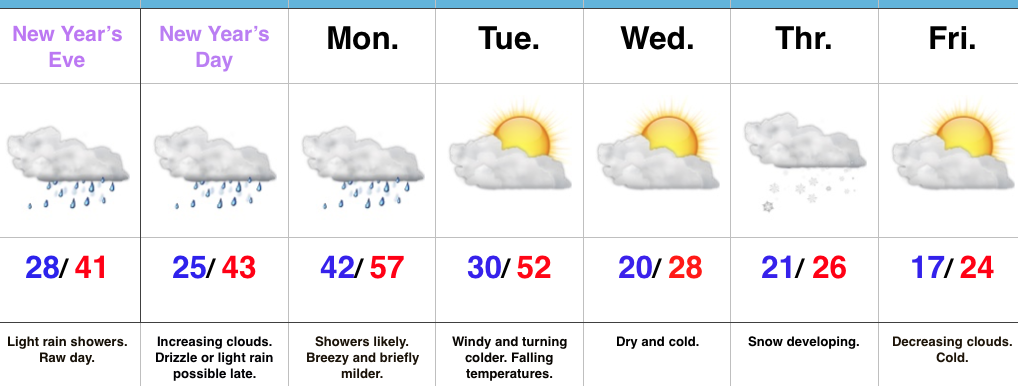
This is, of course, is in stark contrast to December 2015.

conus_mtd_t2max_anom_2015
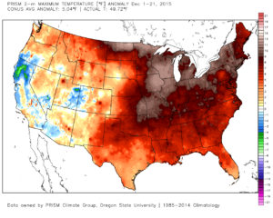
As we move forward, an active pattern awaits between now and the end of the year.  This comes after a few days to catch our breath, including moderating temperatures leading up to Christmas.

An initial wave of moisture will lift northeast and result in a rather gloomy day Friday with increasing rain chances Friday afternoon and evening.  Initially, precipitation won’t make it to the ground, but we should saturate the column enough that rain reaches the ground for most of central IN by evening.  Showers continue Friday night into the wee morning hours Christmas Eve.  (If traveling towards Chicago, a wintry mix and snow will be a good bet Friday PM).

hires_ref_ky_18Christmas Eve will feature overcast skies with areas of fog and drizzle, but the majority of the concentrated rain should fall south of the region.  Santa’s ride into central IN should be uneventful, weather-wise.

Christmas Day will start off with temperatures in the mid to upper 30s along with cloudy conditions and an increasingly gusty breeze that will shift out of the southeast to the south Christmas night.  Shower chances will be present by the evening before giving way to more widespread showers and embedded thunder overnight into Monday morning.  Temperatures will be stuck in the 40s most of the daytime Christmas before rising into the upper 50s predawn Monday.

gfs_ptype_slp_indy_17
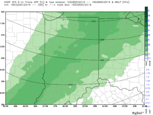
Temperatures will fall through the day Monday and we should run much closer to seasonable temperatures next week.  A couple of additional storm systems will have to be monitored for rain and snow prospects the middle of next week and again around New Year’s Eve/ Day.  Initially, we’ll be rather mild, but there may be more in the way of cold air readily available to make the storm system around New Years “more interesting” from a wintry perspective.

Longer term, we have to wonder if the negative EPO isn’t about to take control just past the New Year.  More and more data is coming around to the idea that the arctic hounds may (yet again) be on the attack early January… Time will tell and we’ll continue to keep a close eye on things.

test8

wpoepo

Permanent link to this article: https://indywx.com/changeable-weather-christmas-to-new-years/

VIDEO: Rambling Around On A Wednesday Evening…

You must be logged in to view this content. Click Here to become a member of IndyWX.com for full access.  Already a member of IndyWx.com All-Access?  Log-in here.

Permanent link to this article: https://indywx.com/video-rambling-around-on-a-wednesday-evening/