Highlights:
- Spring-like air continues
- Severe t-storm potential Friday PM
- Much colder weekend
- Another round of strong-severe storms next week?
Buckle Up For A Wild Ride…Morning fog (some very dense, especially north of the city) will burn off and give way to increasing sunshine today, along with unseasonably warm temperatures. In fact, we’ll be near-record territory (Indy’s record high today is 70° and we forecast to tie that record this afternoon). We’ll remain near record territory over the next couple of days, but our attention will, unfortunately, have to shift from the record warmth to strong-severe thunderstorm potential.
Most of Thursday will be dry, but a few scattered showers will likely dot the central IN landscape by the evening hours. Similar to Thursday, most of the day Friday will also be dry. It’s not until we head into Friday evening and night that we’re concerned for thunderstorms tracking through the state. A few of these storms will likely reach severe levels. Large hail and damaging winds are of greatest concern with the severe thunderstorms that develop. The cold front will sweep the state Friday night and a midnight high Saturday morning in the upper 40s will crash (most of the daytime will feature temperatures in the 30s with wind chills in the 20s) and wind-whipped snow flurries can be expected.
A weak weather system is still expected late Sunday and could feature a light rain and snow mix (not a big deal). What will be a bigger deal is a much stronger storm system rolling through the Mid West early next week. Unfortunately, another round of strong to severe thunderstorms will be possible Tuesday…
Upcoming 7-Day Precipitation Forecast:
- Snowfall: Trace
- Rainfall: 1.00″ – 1.50″
 The anomalous warmth is impressive enough, but perhaps the most impressive is the duration of the unseasonably warm, April-like, warmth. By the time all is said and done (Friday night), many communities will set multiple new records for so many consecutive days of 60°+ level warmth in the month of February. That doesn’t set well for spring vegetation. Given the look to the overall pattern in the weeks ahead, it’s hard to deny the glaring signs for additional well above normal warmth (speaking in “overall” terms). Accordingly, vegetation will likely continue to sprout and bloom early with such a pattern- even as far north as here in central IN.
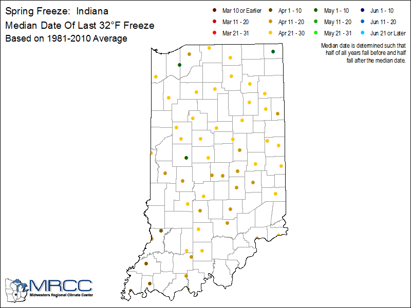
 Highlights:
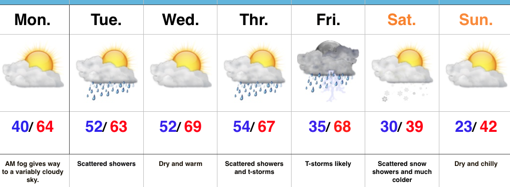 Highlights:
 Despite the lack of sunshine this morning, temperatures continue to run much milder than average. We’re currently running nearly 20° above where we should be at the 9a hour.
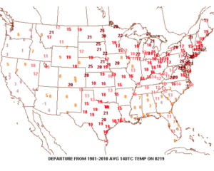 A quiet start to the work week is ahead as high pressure dominates early on. That said, a weak storm system will scoot through the state Monday night and Tuesday morning and this will help offer up the chance of showers and perhaps a rumble of thunder.
 The next (more significant) storm system will pose a severe weather risk to close the week. We continue to keep a close eye on Friday and the Storm Prediction Center is as well, with western IL, IN, and western KY in their Day 6 Outlook. It’s still early, but the primary focus with the severe potential this storm may pose will be large hail and damaging straight line winds. Stay tuned as we continue to analyze the latest data.
 We’ll turn sharply colder Friday night and Saturday. Though it’ll feel much colder, we’ll really only “chill” to seasonal levels, including a gusty northwesterly breeze Saturday.
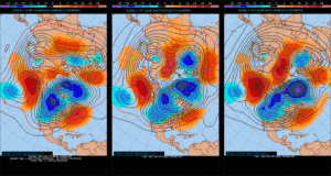
 Longer-term, we’re rumbling into a much more active weather pattern through the mid range period. As the mean trough sets-up position in the west, the ridge will flex it’s muscle across the east yet again during early portions of Week 2. This will set the stage for a repeat of what we deal with Friday and, accordingly, we’ll have to monitor early next week for portions of severe weather yet again.