Active Times, My Friend…

We enjoyed a brilliant Saturday across central Indiana. Plentiful sunshine developed, as expected, after a cloudy, drizzly start in areas. Temperatures topped out in the mid to upper 60s for…

You must be logged in to view this content. Click Here to become a member of IndyWX.com for full access.  Already a member of IndyWx.com All-Access?  Log-in here.

Saturday Morning Rambles…

April is running nearly 6° below average and nearly spot-on where we should be from a precipitation perspective through the 15th.       As we move forward, the big story…

You must be logged in to view this content. Click Here to become a member of IndyWX.com for full access.  Already a member of IndyWx.com All-Access?  Log-in here.

This Is More Like It…

Screen Shot 2016-04-11 at 9.51.07 AMHighlights:

  • Wet open to the work week
  • Shot of colder air
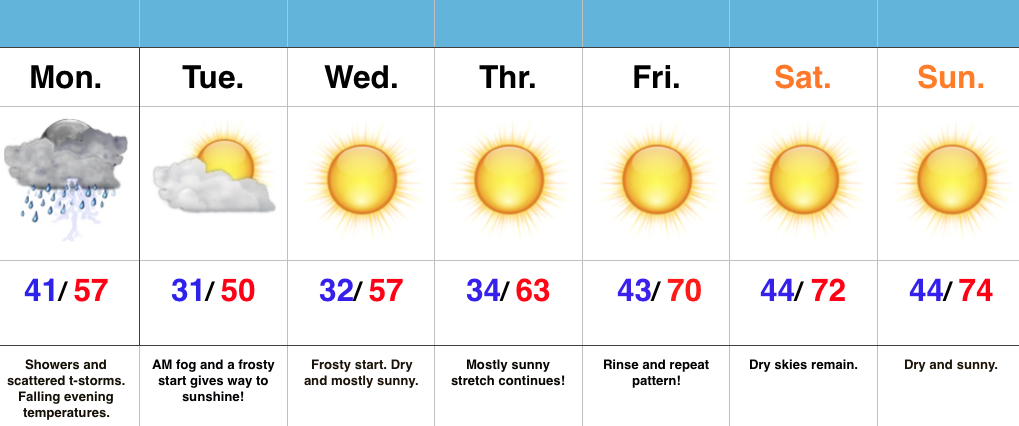
  • Extended dry, sunny stretch coming

Good Supply Of Vitamin D Coming…While the work week is opening cloudy, wet, and gloomy, it certainly won’t end that way.  Rain will end from west to east this afternoon.  Before we get into the much deserved pattern change later this week, we’ll deal with one more shot of chilly air arriving tonight and Tuesday with a brisk NW wind.  Sub-freezing temperatures are a good bet for most Tuesday and Wednesday mornings.

Once to Thursday, we’re “off to the races” as far as temperatures go- adding a couple degrees on afternoon highs each afternoon.  Wall-to-wall sunshine will dominate the forecast as we wrap up the work week and head into the weekend.  Enjoy, friends!

Bitterly Cold By April Standards…

Screen Shot 2016-04-09 at 8.09.05 AMHighlights:

  • Cold times continue
  • Rain arrives Sunday
  • Monday storms
  • Slowly moderating late next week

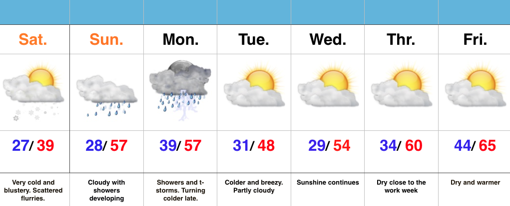
Bundle Up…With temperatures in the middle and upper 20s this morning and ‘chills in the 10s, it’s hard to believe we’re nearing mid-April!  It’s simply downright bitter by April standards.  Early snow showers and flurries should diminish as we progress into the afternoon hours with decreasing cloudiness, as well.

Dry times won’t last long as a warm front approaches Sunday.  This will deliver a thick overcast back to the region, along with developing showers and embedded thunder into Monday.  Early rain numbers into the forecast office offer up the potential of 0.75″-1.25″ on average in the Sunday-Monday time period.

We’ll turn colder and breezy (surprise, surprise) Monday night into the middle of the week, BUT moderating temperatures will develop by late week!  60s are in store for afternoon highs Thursday-Friday with lots of sunshine!  Hang in there, friends!