Category: Unseasonably Cool Weather

Hope You Like Winter…

Screen Shot 2016-01-09 at 7.20.28 AMHighlights:

  • Rain changes to snow
  • Much colder and windy
  • Quick-hitting intense snow squalls
  • Arctic air

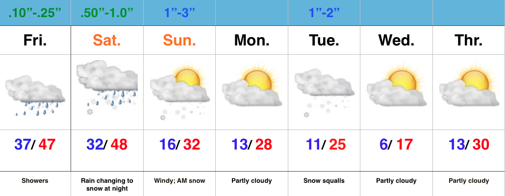
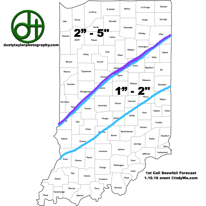
Rain To Snow Late Tonight…Most of today will be mild, but big changes will take place tonight as cold air whips around an area of low pressure that will deliver rain, especially the second half of the day.  With the colder air moving in, rain will change to snow overnight and stick in spots.  Timing the changeover is key in obviously determining snow amounts, but after looking over morning data, we feel as good as we can about our initial snowfall map issued last night.  Additional fine tuning may be required later today, and bust potential remains high.

1stCallSnowfallMap11016
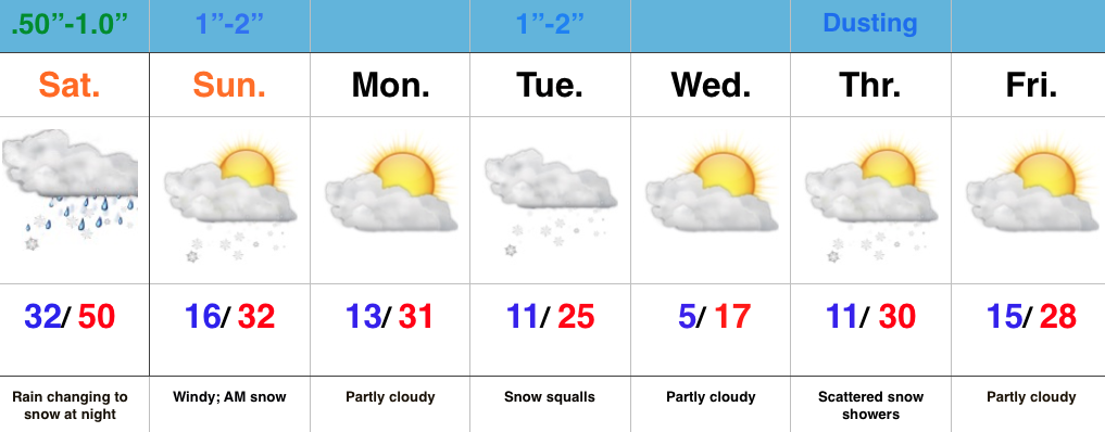
The second half of the weekend will feature morning snow along with strong and gusty north winds.  It’ll be a harshly colder day (don’t let that high around freezing fool you, as that will take place around midnight).

Monday will dawn very cold, but dry, but the quiet times will be brief.  Clouds will increase late day and snow will develop Monday night into Tuesday morning.  Embedded heavy, quick-hitting, snow squalls will accompany arctic reinforcements Tuesday morning and set up a messy morning commute.

A third snow maker is possible Thursday and then our attention turns to next weekend for additional wintry “fun and games.”  Get the idea now that we’re in a drastically different pattern when compared to December?

Permanent link to this article: https://indywx.com/hope-you-like-winter/

Saturday Night-Sunday Challenges…

Here’s our initial snowfall map, brought to you by dustytaylorphotography.com.

1stCallSnowfallMap11016

Permanent link to this article: https://indywx.com/6103/

Busy Times; Winter To Make A Come Back…

Screen Shot 2016-01-08 at 7.01.21 AMHighlights:

  • Wet close to the week
  • Rain to snow Saturday night into early Sunday
  • One-two punch of arctic air
  • Snow squalls Tuesday

Wet Close To The Week; Winter Blows In To Town…The region will deal with two storm systems as we go through the next few days.  Today’s area of low pressure will be responsible for pushing rain showers through the state and while it won’t rain the entire day, it’ll be wise to keep the rain gear nearby.

A secondary area of low pressure will lift northeast Saturday into Saturday night.  Heavier rains will arrive into central IN Saturday afternoon and the precise track of this second area of low pressure is key in determining the transition from rain to snow as cold air arrives on the scene.  As of now, we’ll focus on a changeover overnight Saturday night/ Sunday morning.  Initial thinking paints a 1″-3″ swath across central IN, but before issuing our first snowfall map, we want to have an opportunity to see the complete 12z model suite.

Regardless of how much snow falls Sunday morning, expect a much colder feel and strong and gusty winds as we go through the second half of the weekend.  Arctic reinforcements arrive Tuesday and we’ll know it.  Expect snow squalls and bitterly cold air for mid week.

Looking ahead, busy times continue down the road.  An early look at next weekend shows a pattern plenty capable for renewed wintry “fun and games…”

Permanent link to this article: https://indywx.com/busy-times-winter-to-make-a-come-back/

The Plot Thickens…

You must be logged in to view this content. Click Here to become a member of IndyWX.com for full access.  Already a member of IndyWx.com All-Access?  Log-in here.

Permanent link to this article: https://indywx.com/the-plot-thickens/

Confidence Increasing On Leader-Follower Event; But Details Murky…

A look over model data from overnight suggests we need to focus on a “leader-follower” event for the upcoming weekend.

We’re confident the “leader” player is a rain maker for IN in the Thursday afternoon-Friday time frame (.40-.70 rainfall potential).

Source: Tropicaltidbits.com

Source: Tropicaltidbits.com

As we progress into the second half of the weekend, details get quite murky on the specifics with the secondary (follower) area of low pressure that develops along a pressing arctic front.

As we’ve been discussing, model solutions will vary within each respected model (GFS, Euro, GEM, etc.) in a run-to-run fashion.  Stack them up against one another, and we’ll likely continue to have as many different solutions as we do models that we’re looking at.  It’s a byproduct of a pattern transition and that crashing SOI (which is still crashing this morning, btw).  Case in point, note the various options below for Sunday.

The GFS takes a low from southern AL into the coastal plain of NC. Source: Tropicaltidbits.com

The GFS takes a low from southern AL into the coastal plain of NC. Source: Tropicaltidbits.com

The Canadian is a blend of the GFS and European as it tracks low pressure from eastern LA into the central Appalachians. Source: Tropicaltidbits.com

The Canadian is a blend of the GFS and European as it tracks low pressure from eastern LA into the central Appalachians. Source: Tropicaltidbits.com

The European is most aggressive in the west track as it takes low pressure from the MO bootheel into northern IN. Source: Tropicaltidbits.com

The European is most aggressive in the west track as it takes low pressure from the MO bootheel into northern IN. Source: Tropicaltidbits.com

Past experience with similar patterns certainly leads us to lean more towards the European/ Canadian solution over the GFS from this distance.  We know that models have their own biases though.  Time and time again the GFS bias is to rush things along a bit too much from this distance and become too progressive.  On the flip side, the European is notorious for dragging it’s heels a bit and, at times, can be too slow with bringing energy out of the west.  This in return impacts things downstream…

From this distance, we still can’t be too specific with snow/ precipitation prospects Sunday.  While confidence is increasing on at least some sort of snow to contend with, the significance of such isn’t possible to iron out at the moment.  Much fine tuning will be required.  Stay tuned.

Permanent link to this article: https://indywx.com/confidence-increasing-on-leader-follower-event-but-details-murky/