VIDEO: Storms Arrive Tonight And We Turn Much Cooler Friday…
You must be logged in to view this content. Click Here to become a member of IndyWX.com for full access. Already a member of IndyWx.com All-Access? Log-in here.
You must be logged in to view this content. Click Here to become a member of IndyWX.com for full access. Already a member of IndyWx.com All-Access? Log-in here.
 Highlights:
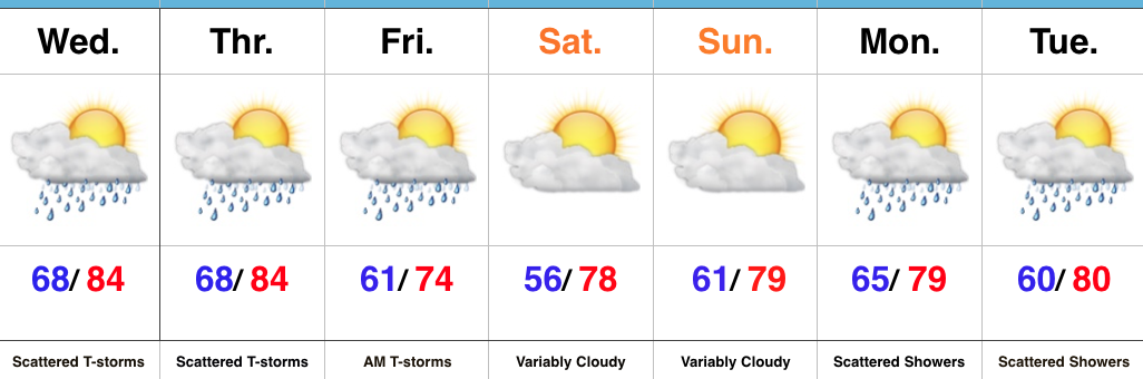
Summer Weather Gives Way To An Early Fall Feel…Seasonably warm and humid conditions will help power widely scattered afternoon and evening thunderstorms again Wednesday. More widespread showers and thunderstorms will arrive Thursday evening into early Friday as a cold front sweeps through the state. Winds will shift around to the northwest and turn gusty Friday afternoon, helping usher in an unseasonably cool air mass for the first Friday of August. This cooler regime will remain with us through the weekend. A quick-moving light shower is possible over the weekend, but most of the area will remain rain-free with mixed clouds and sun.
Temperatures will remain below seasonal norms early next week (and really throughout the majority of the first half of August) with scattered rain chances returning to our forecast. Looking beyond the current 7-day period shows our next storm system of significance approaching mid-to-late next week.
Upcoming 7-Day Precipitation Forecast:
1.) 2017 continues to fly along. August features 3.13″ of rain during the month and temperatures that start out with an average high and low of 84°/ 65° and 83°/ 62° to end the month. Needless to say, temperatures this weekend will feature well below normal conditions that will feel more like it should jumping forward 6 weeks, or so.
2.) Moisture returns today and results in scattered shower coverage this afternoon and Wednesday. Most of both days will remain rain-free, but don’t be surprised by a passing shower at times.
3.) More widespread coverage of showers and thunderstorms arrive Thursday afternoon into Friday morning as a strong cold front presses into the state. Localized heavy rain is possible and rainfall totals of 0.50″-1.00″ can be expected (with locally heavier amounts under stronger storms) between now and Friday.
 4.) As surface low pressure wraps up over the Great Lakes Friday, it’ll help pull unseasonably cool air south into the state, along with gusty northwest winds. In fact, temperatures will remain steady or slowly fall as we move through the day Friday. It sure won’t feel like the first weekend of August as temperatures tumble into the 50s area-wide Saturday morning.
You must be logged in to view this content. Click Here to become a member of IndyWX.com for full access. Already a member of IndyWx.com All-Access? Log-in here.
 Highlights:
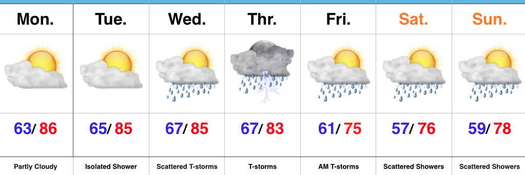
Welcome To A New Work Week…As we open the new work week, we’ll continue to deal with the same weather pattern that provided us the delightful weather over the weekend. High pressure will grudgingly give up control Tuesday into Wednesday with moisture returning. Initially, coverage of showers will be “spotty” at best, but better coverage of showers and thunderstorms will return as we progress into midweek. Thursday appears to be the wettest day as a cold front pushes closer to the region.
That cold front will sweep through the state Friday morning and result in a MUCH cooler air mass filtering into the region as we close the work week and head into the weekend. While we’ll certainly notice the much cooler air, we have to maintain mention of a passing shower over the weekend thanks to lingering upper level energy. Despite scattered showers around the region, most of the weekend will be rain-free. The bigger story will be the late-September like air over the weekend.
Upcoming 7-Day Precipitation Forecast: