You must be logged in to view this content. Click Here to become a member of IndyWX.com for full access. Already a member of IndyWx.com All-Access? Log-in here.
Category: Uncategorized
Permanent link to this article: https://indywx.com/video-times-they-are-a-changin/
Apr 24
Wetter Trends…
The relatively quiet stretch of weather of the past several days has been nice. Unfortunately, as attention shifts to what lies ahead, quiet times are limited. Even in the short term, guidance has trended significantly wetter with the Thursday PM-Friday AM period, and longer term the story remains focused on heavy rain next week.
Tomorrow morning’s post will focus more on the longer range pattern, but tonight we wanted to provide a quick update on the storm system set to arrive tomorrow into Friday morning.

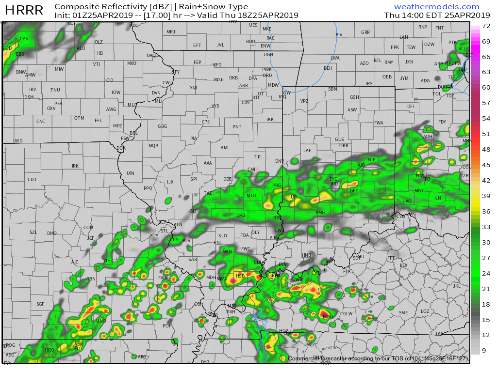
A few showers will be around the I-70 corridor tomorrow morning, but these shouldn’t be a huge deal and coverage will remain scattered in nature.
That begins to change as we move into Thursday afternoon with more widespread rain and some embedded moderate to heavy showers anticipated.

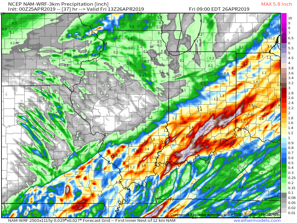
Thereafter, widespread rain should continue into early Friday morning. The axis of heavy rain has trended much further NW when compared to even this morning. Now, most guidance brings the 1” totals as far north as the Indianapolis region. Lighter amounts will be seen northwest of the city.

We still think rain will come to an end Friday morning and we should introduce an increasingly sunny sky as we get set to wrap up the work week.
Much more in the AM on what lies ahead over the weekend into next week…
Permanent link to this article: https://indywx.com/wetter-trends/
Jan 17
Unsettled And Mild…
 Highlights:
- Crossing our fingers for a few looks at the sun
- Windy, rainy conditions return
- Spring-like weekend ahead
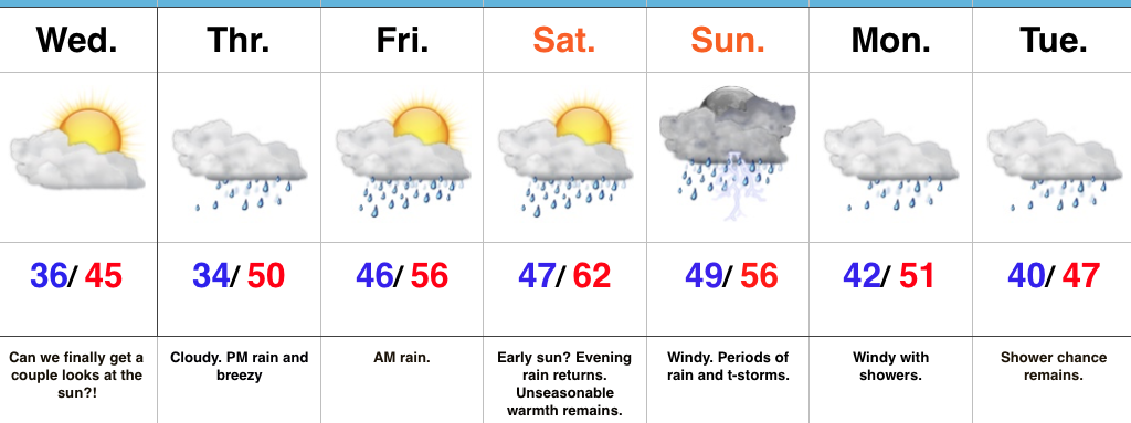
Hang On To The Rain Gear…We’re in the midst of a downright gloomy stretch of weather and, unfortunately, the overall trend remains locked in to a dreary regime. That said, there will be an opportunity for at least a few looks at the sun Wednesday as we’ll be in between storm systems. Our fingers are crossed!
Any sun will quickly fade and give way to increasing clouds Thursday and blustery, rainy conditions by the afternoon. Rain will likely grow heavy at times Thursday night into early Friday morning before another stretch of briefly drier conditions build in Friday PM through early Saturday.
Our active pattern remains this weekend, as a wound-up storm system promises a wet, windy, and stormy close to the weekend. Similar to our late week storm, additional heavy rain seems likely, as a gulf connection will be in place. Though heavy rain will take the headlines, the “spring fling” is also noteworthy. Highs this time of year normally are in the middle 30s. For some through central IN, highs will approach a whopping 30 degrees above normal.
Upper level energy remains early next week with pesky showers continuing, along with breezy conditions.
Upcoming 7-Day Precipitation Forecast:
- Snowfall: 0.00″
- Rainfall: 1.50″-2.00″ (locally heavier totals)
Permanent link to this article: https://indywx.com/unsettled-and-mild/
Dec 20
Pattern Moderates, But Stays Busy…
 Highlights:
- Fast-moving storm system scoots north
- Wintry mix Friday night?
- Christmas night t-storm?
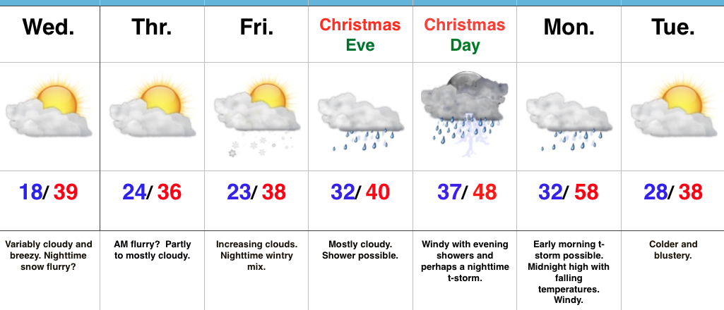
Chilly, But “Less Harsh”…The average high and low in central Indiana to wrap up December fall in the upper 30s and lower 20s, respectfully. While much milder than we’ve been, temperatures will be very close to seasonal norms as we rumble into Christmas weekend. A fast-moving storm system will scoot across the Great Lakes region Wednesday afternoon. Reinforcing chilly air (not of arctic origin) will blow in Wednesday night and Thursday. While a flurry could fly Wednesday night into Thursday morning, this won’t be a big deal.
We’ll then shift our focus to Christmas. An initial wave of moisture could result in a light wintry mix as early as Friday night. Initial thinking is that this won’t be a big deal as a quick transition to rain should take place early morning Christmas Eve, but, nonetheless, we’ll keep a close eye on things. A light shower may still be around Christmas Eve, especially during the first part of the day. Christmas Day, itself, should feature mostly dry, windy, and mild conditions. Wind-blown showers are possible by afternoon before intensity increases Christmas night, including the potential of a strong thunderstorm. The cold front will sweep through the state Monday morning with colder and windy conditions continuing Monday into Tuesday.
Longer-term, we remain confident that the “relaxed” state in the bitterly cold pattern will continue. However, please know that doesn’t mean we won’t have to deal with wintry threats over the next couple of weeks. An active storm track will continue through the Ohio Valley…
Upcoming 7-Day Precipitation Forecast:
- Snowfall: Dusting – 1″
- Rainfall: 0.50″ – 1.00″
Permanent link to this article: https://indywx.com/pattern-moderates-but-stays-busy/
Oct 25
Tuesday Morning Briefing…
I’m on the road this morning so this will be quick (hoping to get a full 7-day out late tonight).
High pressure will supply a beautiful fall Tuesday. Patchy frost has been reported across central IN this morning (mid to upper 30s for some). Highs today will top out in the upper 50s to lower 60s with partly cloudy skies.
Our next storm system will serve to offer up showers by Wednesday evening (most around, or just after, the evening rush). It’ll be a windy day as well as SW winds gust over 30 MPH at times, especially during the afternoon.


A rumble or two of thunder is possible across central IN Wednesday evening and rainfall amounts should fall in the 0.25″-0.50″ range for most neighborhoods.
While we’ll turn briefly cooler behind the front to close the work week, the big news in an unseasonably warm close to October and open to November (several days with highs in the 70s develop this weekend into next week).

That said, MAJOR changes loom as mid November approaches. In fact, a rather dramatic shift towards a significantly colder and increasingly wintry feel looks likely as mid November approaches. This fits the pattern and analogs since summer.
Permanent link to this article: https://indywx.com/tuesday-morning-briefing/


